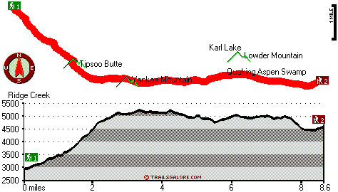
| |
|
| | Oregon is a good place for backcountry trekkers. There are many glorious trails in Oregon, and Tipsoo Trail is one of them, and it's in Lane County. Tipsoo Trail is in a rather deserted vicinity, and when you spend some time backpacking here you will feel like a whole new person. During the months of summer at Tipsoo Trail temperatures are mostly in the 80's while overnight lows are typically in the 40's. The wintertime brings highs down to the 40's; after the sun is down throughout the wintertime temperatures at Tipsoo Trail drop into the 20's. Every trail |
|
in Oregon is different from the others. This is one of many wilderness hiking trails in the surrounding vicinity. This trek should take you about 2.5 days, so better have big backpack to fit all the stuff you need. Tipsoo Trail is quite long, so make sure you bring plenty of supplies.
| | Please follow all local rules about fires and camping. Tipsoo Trail has a total elevation difference of 2,848 feet which is higher than average. We all need to get out in the fresh air once in a while, and Tipsoo Trail in Lane County, Oregon is such an outstanding location. This hiking trail has two trailheads, so backcountry backpacking it one way is an option if you can arrange for a ride back. Some parts of this backcountry trail are much higher up than other parts of the backcountry trail, so keep in mind that you may need to dress differently at different | |
|
elevations. The length of this hiking trail is on the longer side with an average amount of climbing distance which makes this wilderness hiking trail pleasant for hard core backpackers looking for adventure. Tipsoo Trail is 17.2 miles long; it's considered a longer hike. The gorgeous
hiking trails of the Central Cascade Range are a good way to explore these highlands. When you're here in Oregon backcountry hiking along one of its trails is so much fun. Sometimes this hiking and backpacking trail gets really dry, so do check for current fire restrictions before
you go if you plan to bring a stove or make a camp fire. A great deal of rainfall falls at Tipsoo Trail; the month with most of the rain is December; July on the other hand is the driest.
Briefly about the general area: A tour to Wolverine Meadow invigorates the spirit;
why not camp at Patio RV Park if you're here at Tipsoo Trail. You clearly have to go for Tipsoo Trail. Near Tipsoo Trail you discover Blue Canyon which is a good place to have a look at, and The Potholes is right here at Tipsoo Trail. You'll really wish for more hours in a
day to enjoy all the exciting things in the Central Cascade Range. Foley Hot Springs is always fun to check out; get drenched paddling on Horse Creek. If you adore the outdoors you'll adore it here in the Central Cascade Range. A short spree to Terwilliger Hot Spring is always
worthwhile. Rebel Creek flows through this vicinity; Twin Springs Campground is a great local campground. There's some flowing water close by, Pat Creek is a stream you can pop by while here, and paddling on McKenzie River - South Fork is so much fun.
|
|
Location of Trailhead 1: Latitude 44.0923, Longitude -122.2151 - - Directions and Road Map
Location of Trailhead 2: Latitude 44.0623, Longitude -122.0909 - - Directions and Road Map

Trailhead 1 to Trailhead 2: Total hiking length = 8.6 miles Total climbing distance = 4.7 miles Difficulty : Difficult Casual Hiking Pace:
8.5 hours
Fast Hiking Pace:
4.5 hours
Trailhead 2 to Trailhead 1: Total hiking length = 8.6 miles Total climbing distance = 2.8 miles Difficulty : Difficult Casual Hiking Pace:
7 hours
Fast Hiking Pace:
4 hours
| | Trailhead 1 back to Trailhead 1: Total hiking length = 17.2 miles Total climbing distance = 7.5 miles Difficulty : Difficult Casual Hiking Pace:
2.5 days
Fast Hiking Pace:
1.5 days
Trailhead 2 back to Trailhead 2: Total hiking length = 17.2 miles Total climbing distance = 7.5 miles Difficulty : Difficult Casual Hiking Pace:
2.5 days
Fast Hiking Pace:
1.5 days
|
Total elevation difference: 2848 feet

Best Western Oakridge Inn, Oakridge
|
28 miles away
This Oakridge, Oregon hotel offers a complimentary continental breakfast each morning and convenient access to a variety of outdoor activities. Discover the Best Western Oakridge Inn, nestled agains...
|
| |
Lodge at Suttle Lake, Sisters
|
38 miles away
We are not your typical hotel. Nestled in the heart of the Deschutes National Forest amid soaring pines. Suttle Lake Resort provides an enchanted escape. Our resorts mountain views and pristine lake w...
|
|
User input for Tipsoo Trail, Central Cascade Range, Lane County, Oregon:

Outdoors Recreation Near Albany-Lebanon, Oregon Very comprehensive list of a variety of outdoors recreation in the vicinity of Albany-Lebanon, Oregon, the metro area neareast to Tipsoo Trail. Find info on campgrounds, hiking trails, ski resorts, lakes, beaches, parks, whitewater and more.
|
Current weather conditions at Tipsoo Trail, Central Cascade Range, Lane County, Oregon

Local climate location: MC KENZIE BRIDGE R S 6 miles away

           
| |
Best Western Ponderosa Lodge, Sisters
|
43 miles away
Offers a refreshing environment with renovated rooms, new deluxe suites and smoke-free accommodations. The perfect choice while traveling the 'Gateway to the Cascades', ideally located on 14 acres sur...
|
Five Pine Lodge, Sisters
|
44 miles away
Lodging in Sisters, Oregon, at FivePine Lodge and Spa is a vacation back in time to Central Oregon's golden era of travel with every modern luxury. Whether you're practicing Tai-Chi atop Eagle Rock, p...
|
|
More Hotels and Campgrounds Near Tipsoo Trail, Central Cascade Range, Lane County, Oregon
| |
| |
 |
|
| These outdoors activities are available near Tipsoo Trail. |
| | Trails Near Tipsoo Trail:
 |
Pyramid Trail, Lane County
County
, 3 miles away, 8.8 hiking miles, 3174 feet elevation difference |
 |
Saddle Trail, Lane County
County
, 3 miles away, 2.4 hiking miles, 1641 feet elevation difference |
 |
Rebel Rock Trail, Lane County
County
, 4 miles away, 10.6 hiking miles, 3608 feet elevation difference |
 |
Frissell Point Trail, Lane County
County
, 6 miles away, 4.6 hiking miles, 3825 feet elevation difference |
 |
Tuckta Trail, Lane County
County
, 7 miles away, 1 hiking miles, 894 feet elevation difference |
 |
Hiyu Trail, Lane County
County
, 8 miles away, 6.8 hiking miles, 1264 feet elevation difference |
 |
Olallie Trail, Lane County
County
, 8 miles away, 10.4 hiking miles, 735 feet elevation difference |
|
| | Whitewater Near Tipsoo Trail:
 |
McKenzie River - South Fork, Lane County
County
, 4 miles away, Class III-IV - 6.2 miles long (Dutch Oven Camp to Cougar Reservoir) |
 |
Horse Creek, Lane County
County
, 5 miles away, Class III - 11 miles long (above Separation Creek to McKenzie River) |
 |
Lookout Creek, -blank- County
County
, 9 miles away, Class III-IV - 2.5 miles long (2.5 miles above Blue River to Blue River) |
 |
Blue River, Linn/ Lane County
County
, 10 miles away, Class IV-V - 4 miles long (Quentin Creek to Blue River Reservoir) |
 |
Quartz Creek, Lane County
County
, 13 miles away, Class II-IV - 5 miles long (Quartz Creek Road Mile 7.5 Bridge to Mile 2 Bridge) |
|
| | Hotels Near Tipsoo Trail:
 |
Best Western Oakridge Inn, Oakridge
, 28 miles away |
 |
Lodge at Suttle Lake, Sisters
, 38 miles away |
 |
Best Western Ponderosa Lodge, Sisters
, 43 miles away |
 |
Five Pine Lodge, Sisters
, 44 miles away |
 |
Best Western Newberry Station, La Pine
, 49 miles away |
|
|
|
 |
|