| |
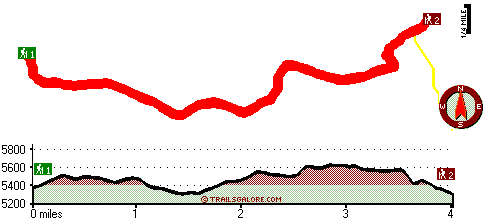
With its 8 miles of walking distance it's an average length great outdoors trail. Keep in mind that this is a long hiking and backpacking trail, so do pack enough food to last the whole trip. This hiking and backpacking trail sometimes gets very dry, so make sure you check current conditions and fire restrictions with local forest authorities before you head out. The total elevation difference for Timpanogas Way is 432 feet, and that is lower than average. This backcountry hike shouldn't take more than 7.5 hours, but of course some folks walk a bit slower and some a bit faster. Timpanogas Way stays roughly within the same elevation zone the whole time, so you get pretty much the same conditions along the whole great outdoors trail. This is a two-ended great outdoors trail with two trailheads which means you have the option of hiking it one way if you have someone to pick you up at the other end.
|
Trailhead 1 to Trailhead 2:
Total hiking length = 4 miles
Total climbing distance = 1.8 miles
Difficulty : Medium
Casual Hiking Pace:
3.5 hours
Fast Hiking Pace:
2 hours
Trailhead 2 to Trailhead 1:
Total hiking length = 4 miles
Total climbing distance = 1.9 miles
Difficulty : Medium
Casual Hiking Pace:
3.5 hours
Fast Hiking Pace:
2 hours
| | Trailhead 1 back to Trailhead 1:
Total hiking length = 8 miles
Total climbing distance = 3.7 miles
Difficulty : Difficult
Casual Hiking Pace:
7.5 hours
Fast Hiking Pace:
5 hours
Trailhead 2 back to Trailhead 2:
Total hiking length = 8 miles
Total climbing distance = 3.7 miles
Difficulty : Difficult
Casual Hiking Pace:
7.5 hours
Fast Hiking Pace:
5 hours
|
Total elevation difference: 432 feet
|


