| |
The total elevation difference for this great outdoors hiking trail is 644 feet which is lower than average. You spend the whole trek in roughly the same elevation zone, so you get pretty much the same conditions along the whole backcountry trail. This is a two-ended great outdoors hiking trail with two trailheads, so backcountry trekking it one way is an option if you can arrange for a ride back. Sometimes this hiking trail gets really dry, so don’t forget to check for any current fire restrictions before you go. Being 10 miles long; it's a long backcountry trail. The time needed for this walk is roughly 9 hours, but of course some people walk a bit slower and some a bit faster. This is a hiking trail that is quite long, so make sure you bring plenty of supplies.
|
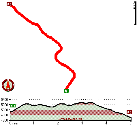
Trailhead 1 to Trailhead 2:
Total hiking length = 5 miles
Total climbing distance = 1.8 miles
Difficulty : Medium
Casual Hiking Pace:
4 hours
Fast Hiking Pace:
2.5 hours
Trailhead 2 to Trailhead 1:
Total hiking length = 5 miles
Total climbing distance = 2.9 miles
Difficulty : Medium
Casual Hiking Pace:
5 hours
Fast Hiking Pace:
3 hours
| | Trailhead 1 back to Trailhead 1:
Total hiking length = 10 miles
Total climbing distance = 4.7 miles
Difficulty : Difficult
Casual Hiking Pace:
9 hours
Fast Hiking Pace:
6 hours
Trailhead 2 back to Trailhead 2:
Total hiking length = 10 miles
Total climbing distance = 4.7 miles
Difficulty : Difficult
Casual Hiking Pace:
9 hours
Fast Hiking Pace:
6 hours
|
Total elevation difference: 644 feet
|


