| |
The trailhead is not 24 miles from Eugene/Spfd. as you say on your home page. It is closer to 40 miles. Says Kelly
This wilderness trail has a total elevation difference of 491 feet which is a lower than average number. At parts of the year this region sees very little rain, so make sure you check current conditions and fire restrictions with local forest authorities before you head out. With its 3.6 miles of walking distance it's a short backpacking and hiking trail. This backcountry hiking trail is not that long but it's always fine to bring some emergency supplies, you never know what could happen. There are two trailheads to chose from, one in each end, so if you can get a ride from someone, you can hike it just one way. You should count on this backcountry walk taking about 3 hours, but you never know stuff could go wrong and you could get stuck so be prepared for that. The backpacking and hiking trail stays roughly within the same elevation zone the whole time, so you won’t have to worry about different climate zones along your backcountry walk.
|
Trailhead 1 to Trailhead 2:
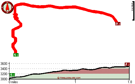
Total hiking length = 1.8 miles
Total climbing distance = 1.2 miles
Difficulty : Medium
Casual Hiking Pace:
2 hours
Fast Hiking Pace:
1 hours
Trailhead 2 to Trailhead 1:
Total hiking length = 1.8 miles
Total climbing distance = .2 miles
Difficulty : Easy
Casual Hiking Pace:
1 hours
Fast Hiking Pace:
.5 hours
| | Trailhead 1 back to Trailhead 1:
Total hiking length = 3.6 miles
Total climbing distance = 1.4 miles
Difficulty : Medium
Casual Hiking Pace:
3 hours
Fast Hiking Pace:
2 hours
Trailhead 2 back to Trailhead 2:
Total hiking length = 3.6 miles
Total climbing distance = 1.4 miles
Difficulty : Medium
Casual Hiking Pace:
3 hours
Fast Hiking Pace:
2 hours
|
Total elevation difference: 491 feet
|


