| |
|
| | Going for a backcountry hike here in Oregon is the wonderful thing to do. There are backcountry trails all over Oregon, and one of those is Sunshine Flat Trail in Baker County. Because Sunshine Flat Trail is very far from modern life, trails like these are splendid. This is a two-ended backcountry trail with two trailheads which means you have the option of trekking it one way if you have someone to pick you up at the other end. When was the last time you got out in the great outdoors a bit? Sunshine Flat Trail in Baker County, Oregon is the great outdoors |
|
at its best. Outdoors people generally like this part of Oregon. This is a vicinity covered with lots of backcountry trails. The time needed for this hike is roughly 9 hours, but you never know stuff could go wrong and you could get stuck so be prepared for that. This great outdoors
| | hiking trail is a great outdoors hiking trail of brilliant length having an average number of uphill miles which makes it a nice backcountry trail for experienced walkers in tremendous shape. The total elevation difference for Sunshine Flat Trail is 2,423 feet which is an average number. Sunshine Flat Trail goes through some very different elevations, so keep in mind that you may need to dress differently at different elevations. At parts of the year this neighborhood sees very little rain, so don’t forget to check for any current fire restrictions before | |
|
you go. The lovely great outdoors hiking trails of the Blue Mountains are the best way to enjoy these hills. Sunshine Flat Trail is 10 miles long; it's longer than many great outdoors hiking trails. This is a trail that is quite long, so make sure you bring plenty of supplies.
Every single Oregon backcountry trail has its own unique attractiveness. Sunshine Flat Trail is pretty dried out regularly; May is when you get the most rain here while July is regularly the driest month. For the period of the warmest time of the year at Sunshine Flat Trail highs
are frequently in the 80's. All through the moonlight hours it's mostly in the 40's. The wintertime comes with highs in the 40's, and nighttime lows at Sunshine Flat Trail during the wintertime mostly sink into the 20's. Please follow all local rules about fires and camping.
Briefly
about the general area: While you're here at Sunshine Flat Trail it's a good idea to explore Sunshine Flat; Fopian Campground is a great local campground. A tour to Bogue Gulch is always fun; don't leave Sunshine Flat Trail without first paying a visit to Trout Farm Spring.
I don't want to stop, cause I'm havin' a brilliant time here at Sunshine Flat Trail. Getting to Crescent Creek from Sunshine Flat Trail is trouble-free. If you came for an overnight stay Wickiup Campground is a glorious location to camp It's always brilliant to take a look at Buck
Spring. Having a great time in the Blue Mountains is uncomplicated. Looking for some flowing water? Try Snow Creek; a pleasant trip to Little Meadows is a good way to spend an afternoon.
|
|
Location of Trailhead 1: Latitude 44.3111, Longitude -118.5271 - - Directions and Road Map
Location of Trailhead 2: Latitude 44.2857, Longitude -118.4963 - - Directions and Road Map

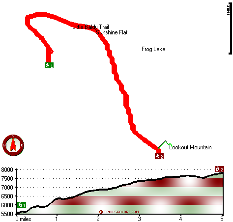
Trailhead 1 to Trailhead 2: Total hiking length = 5 miles Total climbing distance = 3.6 miles Difficulty : Difficult Casual Hiking Pace:
5.5 hours
Fast Hiking Pace:
3 hours
Trailhead 2 to Trailhead 1: Total hiking length = 5 miles Total climbing distance = .5 miles Difficulty : Easy Casual Hiking Pace:
3.5 hours
Fast Hiking Pace:
2 hours
| | Trailhead 1 back to Trailhead 1: Total hiking length = 10 miles Total climbing distance = 4.1 miles Difficulty : Difficult Casual Hiking Pace:
9 hours
Fast Hiking Pace:
5.5 hours
Trailhead 2 back to Trailhead 2: Total hiking length = 10 miles Total climbing distance = 4.1 miles Difficulty : Difficult Casual Hiking Pace:
9 hours
Fast Hiking Pace:
5.5 hours
|
Total elevation difference: 2423 feet

Best Western John Day Inn, John Day
|
31 miles away
This charming John Day, Oregon hotel is minutes from a variety of outdoor activities and walking distance from many local shops and restaurants. Located in Eastern Oregon's beautiful John Day Valley...
|
| |
|
User input for Sunshine Flat Trail, Blue Mountains, Baker County, Oregon:

Outdoors Recreation Near La Grande, Oregon Very comprehensive list of a variety of outdoors recreation in the vicinity of La Grande, Oregon, the metro area neareast to Sunshine Flat Trail. Find info on campgrounds, hiking trails, ski resorts, lakes, beaches, parks, whitewater and more.
More Hotels and Campgrounds Near Sunshine Flat Trail, Blue Mountains, Baker County, Oregon
| |
|
| These outdoors activities are available near Sunshine Flat Trail. |
| | Trails Near Sunshine Flat Trail:
 |
Little Baldy Trail, Grant County
County
, 1 miles away, 10.2 hiking miles, 3398 feet elevation difference |
 |
Starvation Trail, Baker County
County
, 3 miles away, 2.3 hiking miles, 1811 feet elevation difference |
 |
Grouse Spring Trail, Grant County
County
, 5 miles away, 11.2 hiking miles, 2535 feet elevation difference |
 |
Snowshoe Creek Trail, Grant County
County
, 6 miles away, 7 hiking miles, 1825 feet elevation difference |
 |
Skyline Trail, Grant County
County
, 7 miles away, 14.8 hiking miles, 2722 feet elevation difference |
 |
Meadow Fork Trail, Grant County
County
, 9 miles away, 8.6 hiking miles, 2337 feet elevation difference |
 |
Reynolds Creek Trail, Grant County
County
, 11 miles away, 1.6 hiking miles, 137 feet elevation difference |
|
|
|
 |
|