Oregon hiking trails - Summit Trail, Central Cascade Range, Jefferson County

   
  Every single Oregon backpacking trail is different from the others. No chance of getting bored in Oregon if you like the outdoors. When you're here in Oregon backcountry backpacking along one of its backpacking trails is something that is always fun to do. Summit Trail is 7.4 miles long it's an average length hiking trail. At Summit Trail during the summertime highs are in the 70's. Summer nighttime lows drop down to the 40's. For the period of the winter the highs are frequently in the 30's with winter lows in the 20's overnight here at Summit Trail.
    Hiking here in the Central Cascade Range is an outstanding way to explore these mountaintops. Summit Trail has a total elevation difference of 1,790 feet which is about average. This is a one trailhead hiking and backpacking trail, so you'll be trekking it in and back out. Summit
Trail is situated a pretty long trip from Bend, but many people like to backcountry walk here to be near the fresh air. Hey, time for a backcountry walk don’t you think? Summit Trail in Jefferson County, Oregon is such a splendid site. Don’t forget to check for any current restrictions or closures before you go. This backcountry trek shouldn't take more than 6.5 hours, but you never know stuff could go wrong and you could get stuck so be prepared for that. This is a long backcountry hiking trail, so make sure you bring plenty of supplies. Sometimes this backcountry  
hiking trail gets really dry, so do check for current fire restrictions before you go if you plan to bring a stove or make a camp fire. Wilderness hiking trails are fine and plentiful in Oregon, and Summit Trail in Jefferson County is one of them. This is just one of a large number of hiking trails in this vicinity. Some parts of Summit Trail are much higher up than other parts of the hiking trail, so keep in mind that you may need to dress differently at different elevations. All the water falling down from the sky makes Summit Trail a wet place; the wettest month of the year is regularly December, that's the one that rains the most, and July on the other hand is the driest. Summit Trail is a mid-length great outdoors trail with an average amount of climbing distance which makes it an excellent hiking trail for experienced backcountry hikers in magnificent shape.

Briefly about the general area:
You might want to pay a visit to Minto Pass if you're here at Summit Trail, and Bear Valley Lake is a pleasant location. Everybody loves Canyon Creek Meadows, and Black Butte Resort is a splendid campground here.
This river is a great place to visit. If you're here at Summit Trail, you could pop by Bear Valley Creek, and a short tour to Two Springs is always worthwhile. Man, is there a lot of enjoyable stuff to do in the Central Cascade Range. Get yourself into a kayak and hit Marion Creek, and if you came for an overnight stay Cold Springs Resort is a brilliant site to camp. So much entertaining stuff to do at Summit Trail, so little time.

Location of Trailhead: Latitude 44.52, Longitude -121.7705
- - Directions and Road Map

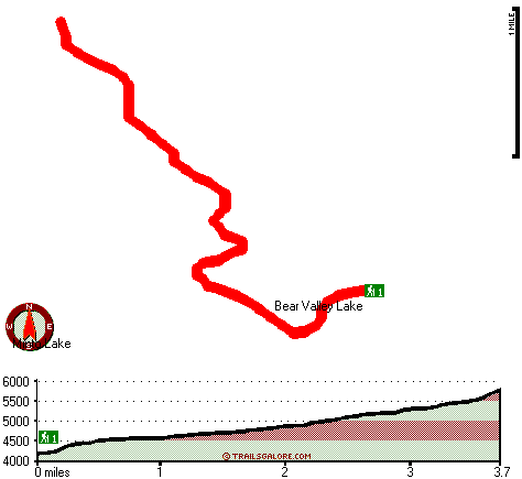
Total in and out hiking length = 7.4 miles

Total climbing distance = 2.9 miles

Difficulty : Difficult

Casual Hiking Pace: 6.5 hours

Fast Hiking Pace: 4 hours

Total elevation difference: 1790 feet


Lodge at Suttle Lake, Sisters
12 miles away
We are not your typical hotel. Nestled in the heart of the Deschutes National Forest amid soaring pines. Suttle Lake Resort provides an enchanted escape. Our resorts mountain views and pristine lake w...
  
Best Western Ponderosa Lodge, Sisters
19 miles away
Offers a refreshing environment with renovated rooms, new deluxe suites and smoke-free accommodations. The perfect choice while traveling the 'Gateway to the Cascades', ideally located on 14 acres sur...
User input for Summit Trail, Central Cascade Range, Jefferson County, Oregon:

Submit Input:
Your Name:
Write or Paste Input here:

Upload picture:      Review Guidelines


Outdoors Recreation Near Bend, Oregon
Very comprehensive list of a variety of outdoors recreation in the vicinity of Bend, Oregon, the metro area neareast to Summit Trail. Find info on campgrounds, hiking trails, ski resorts, lakes, beaches, parks, whitewater and more.

Current weather conditions at Summit Trail, Central Cascade Range, Jefferson County, Oregon
WXPort

Local climate location: MARION FRKS FISH HATCH 17 miles away

Sisters Inn & Suites, Sisters
20 miles away
Just a short drive to Redmond and Bend, the Sisters Inn and Suites offers convenience too many local attractions including Downtown Sisters, Fly Fishers Place, Black Butte Ranch, Les Schwab Amphitheat...

Five Pine Lodge, Sisters
21 miles away
Lodging in Sisters, Oregon, at FivePine Lodge and Spa is a vacation back in time to Central Oregon's golden era of travel with every modern luxury. Whether you're practicing Tai-Chi atop Eagle Rock, p...

More Hotels and Campgrounds Near Summit Trail, Central Cascade Range, Jefferson County, Oregon

OTHER_INFO
  Central Cascade Range Campgrounds
Complete list of all the campgrounds in the Central Cascade Range.

Central Cascade Range Outdoors Info
Complete outdoors info for the Central Cascade Range.

Oregon Hiking Trails
Complete list of all hiking trails in Oregon

Books about hiking trails in Oregon
List of books available on Amazon.com about hiking trails in Oregon.

Oregon Outdoors Index
This is a very comprehensive index of outdoors activities in the great state of Oregon.


TOPO
High quality water resistant topo map of Summit Trail, Central Cascade Range, Jefferson County, Oregon.

OUTDOORS_GUIDE
These outdoors activities are available near Summit Trail.
 Trails Near Summit Trail:
Brush Creek Trail, Jefferson County County , 2 miles away,  6.4 hiking miles, 1347 feet elevation difference
Minto Pass Trail, Linn County County , 2 miles away,  8.4 hiking miles, 967 feet elevation difference
Cabot Lake Trail, Jefferson County County , 3 miles away,  6.8 hiking miles, 941 feet elevation difference
Little Lake Trail, Jefferson County County , 4 miles away, 6.3 hiking miles, 1199 feet elevation difference
Round Lake Trail, Jefferson County County , 5 miles away,  4.2 hiking miles, 627 feet elevation difference
Sugar Pine Ridge Trail, Jefferson County County , 5 miles away,  13.8 hiking miles, 2926 feet elevation difference
Swallow Lake Trail, Linn County County , 5 miles away,  14.4 hiking miles, 3182 feet elevation difference
 Camp Grounds Near Summit Trail:
Cold Springs Resort, Camp Sherman, 11 miles away
Black Butte Resort, Camp Sherman, 11 miles away
Wizard Falls Campground, Jefferson County, 11 miles away
Suttle Lake Resort and Marina, Sisters, 12 miles away
Trout Lake Campground, Jefferson County, 14 miles away
 Whitewater Near Summit Trail:
Marion Creek, Linn County County , 9 miles away, Class IV(V) - 7 miles long (Gooch Falls)
 Hotels Near Summit Trail:
Lodge at Suttle Lake, Sisters , 12 miles away
Comfort Inn, Sisters , 19 miles away
Best Western Ponderosa Lodge, Sisters , 19 miles away
Sisters Inn & Suites, Sisters , 20 miles away
Sisters Motor Lodge, Sisters , 20 miles away
 Lakes Near Summit Trail
Minto Lake, Jefferson County , 2 miles away
Rockpile Lake, Jefferson County , 2 miles away

Outdoors related information copyright © Stratus-Pikpuk, Inc. - Detailed hotel information copyright © Interactive Hotel Solutions