Oregon hiking trails - Summit Creek Trail, Wallowa Mountains, Wallowa County

   
  Many miles from the closest settlement you have Summit Creek Trail, and it's one of those places where hiking is great. Here in the wonderful state of Oregon backpacking never gets boring. Hiking here in Oregon is a must. There are two trailheads to chose from, one in each end which means you have the option of backcountry trekking it one way if you have someone to pick you up at the other end. Don’t forget to check for any current restrictions or closures before you go. The time needed for this hike is roughly 8 hours, but of course some folks walk
    a bit slower and some a bit faster. Summit Creek Trail goes through some very different elevations, so keep in mind that you may need to dress differently at different elevations. Keep in mind that this is a long trail, so don't forget to pack enough supplies. With its 9.4 miles
of walking distance; it's longer than many hiking trails. This is one of a very small number of hiking and backpacking trails in this region. Ok, you've been cooped up too long, time to get out in the outdoors a bit, and Summit Creek Trail in Wallowa County, Oregon is just what you need. At parts of the year this vicinity sees very little rain, so don’t forget to check for any current fire restrictions before you go. All through the summer months highs here at Summit Creek Trail reach the 80's. When the night sets in temperatures sink down into the 40's.  
Highs during the wintertime are typically in the 30's; winter nights come with lows in the 10's to Summit Creek Trail. Oregon has plenty of wonderful hiking and backpacking trails, and one of those is Summit Creek Trail in Wallowa County. The total elevation difference for this great outdoors trail is 3,050 feet which is higher than average. Each one of the many hiking and backpacking trails of Oregon has its own character. Summit Creek Trail is ordinarily a pretty dried up site; of all the months in a year December is the one with the most snow, and July meanwhile is the driest month. Summit Creek Trail is many miles long with an average amount of climbing distance which makes this hiking and backpacking trail perfect for hard core backpackers looking for adventure. Backcountry trails like this one here in the Wallowa Mountains are a very nice way to see these highlands.

Briefly about the general area:
Put some time aside to spend at Ralph Spring since you're here at Summit Creek Trail; The Saddle is another magnificent spot to explore nearby. And if that's not enough there's plenty more cool stuff to do in the Wallowa Mountains. Tepee Spring is always fun to check out; of course P O Creek flows through this region.
Be careful coming to Summit Creek Trail, you might not ever wanna go back home again. Get drenched paddling on Snake River. There's so much to do here at Summit Creek Trail that you need to camp here for a while, Vermillion Bar Campground is a nice location for that. If you're here at Summit Creek Trail, you could check out Trail Creek, and Summit Creek Trail is nice enough to spend more than a day at, Dove Creek Campground is a nice local campground.

Location of Trailhead 1: Latitude 45.2947, Longitude -116.7972
- - Directions and Road Map

Location of Trailhead 2: Latitude 45.2538, Longitude -116.7529
- - Directions and Road Map


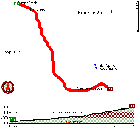
Trailhead 1 to Trailhead 2:
Total hiking length = 4.7 miles
Total climbing distance = 3.2 miles
Difficulty : Difficult
Casual Hiking Pace: 5 hours
Fast Hiking Pace: 3 hours

Trailhead 2 to Trailhead 1:
Total hiking length = 4.7 miles
Total climbing distance = .5 miles
Difficulty : Easy
Casual Hiking Pace: 3 hours
Fast Hiking Pace: 1.5 hours
    Trailhead 1 back to Trailhead 1:
Total hiking length = 9.4 miles
Total climbing distance = 3.7 miles
Difficulty : Difficult
Casual Hiking Pace: 8 hours
Fast Hiking Pace: 5 hours

Trailhead 2 back to Trailhead 2:
Total hiking length = 9.4 miles
Total climbing distance = 3.7 miles
Difficulty : Difficult
Casual Hiking Pace: 8 hours
Fast Hiking Pace: 5 hours

Total elevation difference: 3050 feet


Best Western Salmon Rapids Lodge, Riggins
33 miles away
Overlooking the famous Salmon River, the Little Salmon River, and their majestic canyons, Best Western Salmon Rapids Lodge welcomes you with comfortable lodge-style furnishings, outstanding amenities,...
  
Best Western Rama Inn & Suites, Enterprise
36 miles away
This full-service Enterprise, Oregon hotel is minutes away from local attractions and is an ideal weekend getaway from busy everyday life. Enjoy a peaceful and relaxing getaway to Northwestern Orego...
User input for Summit Creek Trail, Wallowa Mountains, Wallowa County, Oregon:

Submit Input:
Your Name:
Write or Paste Input here:

Upload picture:      Review Guidelines


Outdoors Recreation Near Lewiston, Idaho-Washington
Very comprehensive list of a variety of outdoors recreation in the vicinity of Lewiston, Idaho-Washington, the metro area neareast to Summit Creek Trail. Find info on campgrounds, hiking trails, ski resorts, lakes, beaches, parks, whitewater and more.

Current weather conditions at Summit Creek Trail, Wallowa Mountains, Wallowa County, Oregon
WXPort

Local climate location: WALLOWA 37 miles away


More Hotels and Campgrounds Near Summit Creek Trail, Wallowa Mountains, Wallowa County, Oregon

OTHER_INFO
  Wallowa Mountains Campgrounds
Complete list of all the campgrounds in the Wallowa Mountains.

Wallowa Mountains Outdoors Info
Complete outdoors info for the Wallowa Mountains.

Oregon Hiking Trails
Complete list of all hiking trails in Oregon

Books about hiking trails in Oregon
List of books available on Amazon.com about hiking trails in Oregon.

Oregon Outdoors Index
This is a very comprehensive index of outdoors activities in the great state of Oregon.


TOPO
High quality water resistant topo map of Summit Creek Trail, Wallowa Mountains, Wallowa County, Oregon.

OUTDOORS_GUIDE
These outdoors activities are available near Summit Creek Trail.
 Trails Near Summit Creek Trail:
Western Rim National Recreation Trail, Wallowa County County , 6 miles away,  7.4 hiking miles, 1434 feet elevation difference
 Camp Grounds Near Summit Creek Trail:
Vermillion Bar Campground, Wallowa County, 7 miles away
Dove Creek Campground, Wallowa County, 7 miles away
Bear Campground, Adams County, 14 miles away
Huckleberry Campground, Adams County, 15 miles away
Black Lake Campground, Adams County, 16 miles away
 Whitewater Near Summit Creek Trail:
Snake River, Wallowa County County , 15 miles away, Class III-IV - 32 miles long (Hells Canyon Dam to Pittsburg Landing)
Snake River, Wallowa County County , 17 miles away, Class II-IV - 71.5 miles long (Hells Canyon Dam to Washington Border)
Wildhorse River, Adamas County County , 18 miles away, Class III-IV - 14 miles long (Bear Creek Bridge to Snake River confluence)
 Hotels Near Summit Creek Trail:
Best Western Salmon Rapids Lodge, Riggins , 33 miles away
Best Western Rama Inn & Suites, Enterprise , 36 miles away

Outdoors related information copyright © Stratus-Pikpuk, Inc. - Detailed hotel information copyright © Interactive Hotel Solutions