| |
|
| | You can't spend all your time indoors you need to get out once in a while, and Sucker Creek Trail in Josephine County, Oregon is the outdoors at its best. As long as you like nature you will like Oregon. There are numerous wilderness trails in Oregon, and each one has its own character. There is only one trailhead, so you'll be trekking it in and back out. Being 8.2 miles long it's an average length wilderness trail. The total elevation difference for Sucker Creek Trail is 1,978 feet which is an average number. Sucker Creek Trail is positioned a quite |
|
long trip from Grants Pass, but it is an outstanding backcountry hiking trail. Some parts of this wilderness trail are much higher up than other parts of the wilderness trail which of course means you need to be prepared for different conditions on different parts of the wilderness
| | trail. Oregon has plenty of magnificent wilderness trails; one of these is Sucker Creek Trail in Josephine County. Don’t forget to check for any current restrictions or closures before you go. If you happen to be in Oregon, why not go backcountry hiking, it is a perfect way to spend some time. The stunning backcountry hiking trails of the Klamath Mountains are the best way to enjoy these mountaintops. Summertime highs at Sucker Creek Trail generally tend to be in the 80's. For the duration of the moonlight hours it's frequently in the 40's. The wintertime | |
|
brings highs down to the 40's; nighttime lows at Sucker Creek Trail during the wintertime frequently descend into the 30's. This backcountry hiking trail is a normal length backcountry hiking trail having an average number of uphill miles which makes this hiking trail good for
hard core backpackers looking for adventure. The time needed for this hike is roughly 7 hours, but of course some folks walk a bit slower and some a bit faster. This is one of many hiking trails in the surrounding vicinity. This wilderness hiking trail sometimes gets very dry,
so do check for current fire restrictions before you go if you plan to bring a stove or make a camp fire. The high level of precipitation makes Sucker Creek Trail a pretty wet spot; most of the rain falls during December while July is the month with the least amount of precipitation.
This is a long wilderness hiking trail, so make sure you bring plenty of supplies.
Briefly about the general area: Life's too short to enjoy all the cool stuff in the Klamath Mountains. Fehley Gulch is next to Sucker Creek Trail and is a great site; a quick tour to Matz
Draw is definitely a great idea. There's just no way anyone can get bored here at Sucker Creek Trail. Sucker Creek Trail is wonderful enough to spend more than a day at, Klamath RV Park is a wonderful local campground; Cedar Spring is a gorgeous site to go to while you're at Sucker
Creek Trail. If you're here at Sucker Creek Trail, you could pop by Thirteenmile Creek, and whitewater paddling is not for everyone but if it's for you then, we recommend Indian Creek Klamath Tributary. You have to beyond doubt dedicate some time to Phantom Meadows while you're
here at Sucker Creek Trail, and Horse Spring is a delightful local attraction. There's so much to do here at Sucker Creek Trail that you need to camp here for a while, West Branch Campground is a brilliant site for that. So much enjoyable stuff in the Klamath Mountains, just
impressive. You're sure to encounter some fine people from Grants Pass here; of course, all our national parks are great places to check out and Oregon Caves National Monument is no exception. A fine spot like Elkhorn Prairie here at Sucker Creek Trail is too splendid to miss, and get your heart pumping on the fine whitewater of Elk Creek.
|
|
Location of Trailhead: Latitude 42.0351, Longitude -123.4079 - - Directions and Road Map
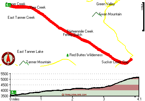
Total in and out hiking length = 8.2 miles
Total climbing distance = 3.1 miles
Difficulty : Difficult
Casual Hiking Pace:
7 hours
Fast Hiking Pace:
4.5 hours
Total elevation difference: 1978 feet

Riverside Inn Resort, Grants Pass
|
21 miles away
As the largest hotel on the Rogue River-Riverside Inn resort and conference center is a preferred location for lodging needs in the area. The Inn boasts spacious guestrooms -all of them with private b...
|
| |
Holiday Inn Express Grants Pass, Or, Grants Pass
|
22 miles away
The Holiday Inn Express Grants Pass is conveniently located at the junction of Interstate 5 and the Redwood Hwy (Hwy 199), offers you easy access to Rogue River thrills, antique shopping, wildlife wat...
|
|
User input for Sucker Creek Trail, Klamath Mountains, Josephine County, Oregon:

Outdoors Recreation Near Grants Pass, Oregon Very comprehensive list of a variety of outdoors recreation in the vicinity of Grants Pass, Oregon, the metro area neareast to Sucker Creek Trail. Find info on campgrounds, hiking trails, ski resorts, lakes, beaches, parks, whitewater and more.
|
Current weather conditions at Sucker Creek Trail, Klamath Mountains, Josephine County, Oregon

Local climate location: CAVE JUNCTION 4 miles away

           
| |
Best Western Grants Pass Inn, Grants Pass
|
22 miles away
Situated at the junction of Interstate 5 and Highway 199, this Grants Pass hotel is just minutes from the famous Rogue River in Oregon. The Best Western Grants Pass Inn is surrounded by beautiful mo...
|
Bestway Inn Grants Pass, Grants Pass
|
22 miles away
Only minutes to Rogue River National Park, the Bestway Inn is conveniently located near Interstate 5 and Highway 199. With easy access to Historic Downtown, Growers Market, Wolf Creek Inn, golfing, h...
|
|
More Hotels and Campgrounds Near Sucker Creek Trail, Klamath Mountains, Josephine County, Oregon
| |
| |
 |
|
| These outdoors activities are available near Sucker Creek Trail. |
| | Trails Near Sucker Creek Trail:
 |
Boundary Trail, Josephine County
County
, 1 miles away, 8.6 hiking miles, 1741 feet elevation difference |
 |
Green Valley Trail, Josephine County
County
, 2 miles away, 1.4 hiking miles, 810 feet elevation difference |
 |
East Fork Sucker Creek Trail, Josephine County
County
, 2 miles away, 6.4 hiking miles, 3375 feet elevation difference |
 |
Limestone Trail, Josephine County
County
, 4 miles away, 4.4 hiking miles, 2926 feet elevation difference |
 |
Lake Mountain Trail, Josephine County
County
, 4 miles away, 5.3 hiking miles, 1760 feet elevation difference |
 |
Bolan Lake Trail, Josephine County
County
, 5 miles away, 1.9 hiking miles, 563 feet elevation difference |
 |
Oregon Caves Trail, Josephine County
County
, 5 miles away, 5.7 hiking miles, 1673 feet elevation difference |
|
| | Whitewater Near Sucker Creek Trail:
 |
Indian Creek Klamath Tributary, Siskiyou County
County
, 10 miles away, Class III - 7.6 miles long (confluence South and East Fork to Klamath River) |
 |
Elk Creek, Siskiyou County
County
, 14 miles away, Class I-IV - 5 miles long (Elk Creek Road to Klamath River) |
 |
Klamath River, Siskiyou County
County
, 16 miles away, Class III - 36 miles long (Sarah Totten Campground to Happy Camp) |
 |
Klamath River, Siskiyou County
County
, 17 miles away, Class III+(IV) - 18 miles long (Happy Camp to Coon Creek) |
 |
Trace Creek, Siskiyou County
County
, 18 miles away, Class IV-V - 7 miles long (Bear Pen Creek to Klamath River) |
|
| | Hotels Near Sucker Creek Trail:
 |
Riverside Inn Resort, Grants Pass
, 21 miles away |
 |
Holiday Inn Express Grants Pass, Or, Grants Pass
, 22 miles away |
 |
Best Western Grants Pass Inn, Grants Pass
, 22 miles away |
 |
Bestway Inn Grants Pass, Grants Pass
, 22 miles away |
 |
Comfort Inn Grants Pass, Grants Pass
, 23 miles away |
|
|
|
 |
|