Oregon hiking trails - Strawberry Basin Trail, Blue Mountains, Grant County

   
  Strawberry Basin Trail is in a relatively isolated region, and what a perfect place for trekking it is. In Oregon you never run out of outdoors fun. Hiking here in Oregon is always an enjoyable thing to do. This backcountry trek should take you about 2 days, so it's a tremendous thing if your backpack is big enough to do the job. This is a long trail, so do pack enough food to last the whole trip. Spending too much time indoors got you down? No problem, Strawberry Basin Trail in Grant County, Oregon is such a perfect place. Each backpacking and hiking
    trail in Oregon is worth backcountry hiking. Some parts of Strawberry Basin Trail are much higher up than other parts of the backcountry trail, and that means that some parts of the backcountry trail could be very different from other parts of it. There is only one trailhead, so
you'll be trekking it in and back out. Trails are delightful and plentiful in Oregon, and one of these is Strawberry Basin Trail in Grant County. The total elevation difference for Strawberry Basin Trail is 2,804 feet, and that is higher than average. This is one of many backcountry hiking trails in the surrounding vicinity. Strawberry Basin Trail is many miles long with an average amount of climbing distance which makes this backcountry hiking trail fine for hard core backpackers looking for adventure. And keep in mind that there could be temporary safety  
restrictions in place. This trail sometimes gets very dry, so do check for current fire restrictions before you go if you plan to bring a stove or make a camp fire. Strawberry Basin Trail gets very little rain; of all the months in a year May is the one with the most rain; the driest month is July. The backcountry hiking trails of the Blue Mountains are a really glorious way to spend quality time in the fresh air. Being 12.6 miles long; it's considered a longer walk. Summertime at Strawberry Basin Trail comes with high temperatures in the 80's. When the night sets in temperatures plunge down into the 40's. The wintertime comes with highs in the 40's, and through the dark hours in the wintertime at Strawberry Basin Trail temperatures plunge to the 20's.

Briefly about the general area:
A short journey to Strawberry Falls is always worthwhile, and if you came to camp Wickiup Campground is a great location to do that. This is such a great river. A tour to Wildcat Basin revitalizes the soul; there's some flowing water nearby, East Fork Indian Creek is a stream you can visit while you're here.
That right there is a load of cool stuff already but it goes on, the Blue Mountains has it all. Take some time to explore Malheur National Forest while you're here. There's so much to do here at Strawberry Basin Trail that you need to camp here for a while, Indian Springs Campground is a brilliant place for that. If you love the outdoors, you'll love Strawberry Basin Trail. Onion Creek flows through this region. A trip to Strawberry Basin Trail wouldn't be complete without taking a look at Strawberry Spring; everybody loves Buckhorn Meadow.

Location of Trailhead: Latitude 44.2902, Longitude -118.718
- - Directions and Road Map

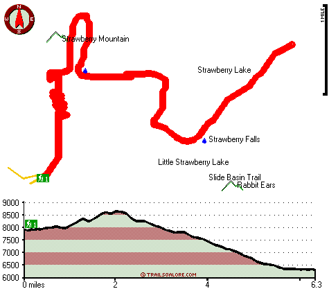
Total in and out hiking length = 12.6 miles

Total climbing distance = 5.6 miles

Difficulty : Difficult

Casual Hiking Pace: 2 days

Fast Hiking Pace: 7.5 hours

Total elevation difference: 2804 feet


Best Western John Day Inn, John Day
19 miles away
This charming John Day, Oregon hotel is minutes from a variety of outdoor activities and walking distance from many local shops and restaurants. Located in Eastern Oregon's beautiful John Day Valley...
  
Americas Best Value Inn, John Day
19 miles away
User input for Strawberry Basin Trail, Blue Mountains, Grant County, Oregon:

Submit Input:
Your Name:
Write or Paste Input here:

Upload picture:      Review Guidelines


Outdoors Recreation Near Pendleton-Hermiston, Oregon
Very comprehensive list of a variety of outdoors recreation in the vicinity of Pendleton-Hermiston, Oregon, the metro area neareast to Strawberry Basin Trail. Find info on campgrounds, hiking trails, ski resorts, lakes, beaches, parks, whitewater and more.

Current weather conditions at Strawberry Basin Trail, Blue Mountains, Grant County, Oregon
WXPort

Local climate location: JOHN DAY 9 miles away

Burns - Days Inn Ponderosa, Burns
43 miles away
Days Inn - Burns is located in Downtown Burns only 3/4 of a mile from Old Camp Casino. We are within walking distance to shopping, a theater and laundry facilities are less than 100 yards away. Days...

Americas Best Inns-Burns, Burns
44 miles away
America's Best Inn and Suites have become known for comfort, value and the friendly attention of a welcoming staff that cares. At America's Best Inns and Suites, we keep your comfort in mind and offer...

More Hotels and Campgrounds Near Strawberry Basin Trail, Blue Mountains, Grant County, Oregon

OTHER_INFO
  Blue Mountains Campgrounds
Complete list of all the campgrounds in the Blue Mountains.

Blue Mountains Outdoors Info
Complete outdoors info for the Blue Mountains.

Oregon Hiking Trails
Complete list of all hiking trails in Oregon

Books about hiking trails in Oregon
List of books available on Amazon.com about hiking trails in Oregon.

Oregon Outdoors Index
This is a very comprehensive index of outdoors activities in the great state of Oregon.


TOPO
High quality water resistant topo map of Strawberry Basin Trail, Blue Mountains, Grant County, Oregon.

OUTDOORS_GUIDE
These outdoors activities are available near Strawberry Basin Trail.
 Trails Near Strawberry Basin Trail:
Slide Basin Trail, Grant County County , 1 miles away,  7.6 hiking miles, 1575 feet elevation difference
Onion Creek Trail, Grant County County , 2 miles away, 7 hiking miles, 1861 feet elevation difference
Twin Springs Trail, Grant County County , 2 miles away,  3.6 hiking miles, 1157 feet elevation difference
Lake Creek Trail, Grant County County , 2 miles away, 3.9 hiking miles, 1998 feet elevation difference
Indian Creek Trail, Grant County County , 3 miles away, 6.6 hiking miles, 3374 feet elevation difference
Pine Creek Trail, Grant County County , 3 miles away,  7.8 hiking miles, 1148 feet elevation difference
Canyon Creek Trail, Grant County County , 3 miles away,  4.4 hiking miles, 1014 feet elevation difference
 Camp Grounds Near Strawberry Basin Trail:
Indian Springs Campground, Grant County, 2 miles away
Wickiup Campground, Grant County, 13 miles away
Ray Cole Campground, Grant County, 16 miles away
Deerhorn Campground, Grant County, 18 miles away
Rock Springs Campground, Grant County, 18 miles away
 National Parks Near Strawberry Basin Trail:
John Day Fossil Beds National Monument, Kimberly - OR , 64 miles away
 Hotels Near Strawberry Basin Trail:
Sag's Motel, Prairie City , 8 miles away
Little Pine Inn, John Day , 18 miles away
Traveler's Motel, John Day , 18 miles away
Dreamers Lodge Motel, John Day , 18 miles away
Best Western John Day Inn, John Day , 19 miles away
 Lakes Near Strawberry Basin Trail
Little Strawberry Lake, Grant County , 1 miles away
Strawberry Lake, Grant County , 1 miles away

Outdoors related information copyright © Stratus-Pikpuk, Inc. - Detailed hotel information copyright © Interactive Hotel Solutions