Oregon hiking trails - Still Creek Trail, Central Cascade Range, Clackamas County

   
  No chance of getting bored in Oregon if you like the great outdoors. There are so many brilliant backpacking trails for backcountry trekking in Oregon, and one of these is Still Creek Trail in Clackamas County. When was the last time you got out in the wilderness a bit? Still Creek Trail in Clackamas County, Oregon is just what you need. And keep in mind that there could be temporary safety restrictions in place. Here in Oregon backcountry trekking is so much fun. Being 3.2 miles long it's a shorter type backcountry hike. Summer brings highs in the
    70's to Still Creek Trail while night lows are mostly in the 50's. High temperatures through the wintertime are normally in the 40's while Still Creek Trail night low temperatures through the wintertime are in the 30's. Still Creek Trail mostly gets much rain; the month of December
is the wettest with most of the rain, and July meanwhile is the driest month. The wilderness trail stays roughly within the same elevation zone the whole time, so you won’t have to worry about different climate zones along your backcountry hike. This is one of many hiking trails in the surrounding region. This is not a very long great outdoors trail but you should still bring some emergency supplies just in case something happens. Each backpacking trail in Oregon has its own unique beauty. You'll must go far from Hood River to get to Still Creek Trail,  
but it sure is a a great great outdoors hiking trail. Still Creek Trail is a two ended trail with two trailheads, so if you can get a ride from someone, you can trek it just one way. This trail has a total elevation difference of 274 feet which is a lower than average number. This hiking trail is a very short hiking trail having an average number of uphill miles which makes this hiking trail great for the average trekker looking for an enjoyable adventure. The picturesque hiking trails of the Central Cascade Range are a really nice way to spend quality time in the great outdoors. You should count on this backcountry trek taking about 3 hours, but of course some people walk a bit slower and some a bit faster.

Briefly about the general area:
Wind Creek is a pretty stream that is worth visiting, and get wet paddling on Sandy River. Camping at Kinzel Lake Campground is always a tremendous experience; why not check out nearby Bruin Run Creek while you're here at Still Creek Trail.
This spot is peerless, just explore all the entertaining things to do close to Still Creek Trail. Since you're here at Still Creek Trail why not stop by Devil Canyon, and you'll meet a lot of people from Hood River here. If you want a splendid time in the great outdoors just come on up to the Central Cascade Range. Camping is available at Devils Meadow Campground; get yourself into a kayak and hit Zigzag River.

Location of Trailhead 1: Latitude 45.3029, Longitude -121.8686
- - Directions and Road Map

Location of Trailhead 2: Latitude 45.2844, Longitude -121.8525
- - Directions and Road Map


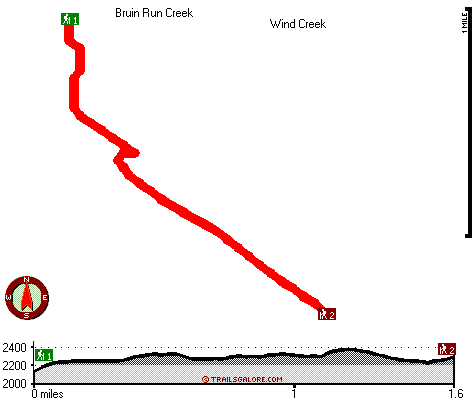
Trailhead 1 to Trailhead 2:
Total hiking length = 1.6 miles
Total climbing distance = .8 miles
Difficulty : Medium
Casual Hiking Pace: 1.5 hours
Fast Hiking Pace: 1 hours

Trailhead 2 to Trailhead 1:
Total hiking length = 1.6 miles
Total climbing distance = .6 miles
Difficulty : Medium
Casual Hiking Pace: 1.5 hours
Fast Hiking Pace: .5 hours
    Trailhead 1 back to Trailhead 1:
Total hiking length = 3.2 miles
Total climbing distance = 1.4 miles
Difficulty : Medium
Casual Hiking Pace: 3 hours
Fast Hiking Pace: 2 hours

Trailhead 2 back to Trailhead 2:
Total hiking length = 3.2 miles
Total climbing distance = 1.4 miles
Difficulty : Medium
Casual Hiking Pace: 3 hours
Fast Hiking Pace: 2 hours

Total elevation difference: 274 feet


Mount Hood Inn, Government Camp
7 miles away
At the Mount Hood Inn we offer our guests the finest accommodations on the mountain. With our modern facilities and friendly local staff we are able to give you the attention and service you have com...
  
Whispering Woods Resort, Welches
7 miles away
Nestled in the heart of the Columbia River Valley, where elements of the natural world will touch your spirit of discovery, Whispering Woods Resort lies surrounded by the beauty of Mount Hood National...
User input for Still Creek Trail, Central Cascade Range, Clackamas County, Oregon:

Submit Input:
Your Name:
Write or Paste Input here:

Upload picture:      Review Guidelines


Outdoors Recreation Near Hood River, Oregon
Very comprehensive list of a variety of outdoors recreation in the vicinity of Hood River, Oregon, the metro area neareast to Still Creek Trail. Find info on campgrounds, hiking trails, ski resorts, lakes, beaches, parks, whitewater and more.

Current weather conditions at Still Creek Trail, Central Cascade Range, Clackamas County, Oregon
WXPort

Local climate location: HEADWORKS PTLD WTR BUR 15 miles away

Whispering Woods (Vri), Welches
7 miles away
Whispering Woods is a resort destination east of Portland which opened in 1981 with 42 condominiums. The second phase of 24 additional condominiums opened in 1992. The resort offers a clubhouse with a...

Resort at the Mountain, Welches
8 miles away
The Resort at The Mountain is the premier Northwest golf and ski resort located in the Highlands of Oregon just an hour east of Portland at the western base of Mt. Hood. The Resort features 160 gues...

More Hotels and Campgrounds Near Still Creek Trail, Central Cascade Range, Clackamas County, Oregon

OTHER_INFO
  Central Cascade Range Campgrounds
Complete list of all the campgrounds in the Central Cascade Range.

Central Cascade Range Outdoors Info
Complete outdoors info for the Central Cascade Range.

Oregon Hiking Trails
Complete list of all hiking trails in Oregon

Books about hiking trails in Oregon
List of books available on Amazon.com about hiking trails in Oregon.

Oregon Outdoors Index
This is a very comprehensive index of outdoors activities in the great state of Oregon.


TOPO
High quality water resistant topo map of Still Creek Trail, Central Cascade Range, Clackamas County, Oregon.

OUTDOORS_GUIDE
These outdoors activities are available near Still Creek Trail.
 Trails Near Still Creek Trail:
Cool Creek Trail, Clackamas County County , 1 miles away, 4.3 hiking miles, 3377 feet elevation difference
Flag Mountain Trail, Clackamas County County , 3 miles away, 1.6 hiking miles, 924 feet elevation difference
Devils Canyon Trail, Clackamas County County , 3 miles away, 5.5 hiking miles, 1797 feet elevation difference
Horseshoe Ridge Trail, Clackamas County County , 3 miles away,  6.6 hiking miles, 2174 feet elevation difference
West Zigzag Mountain Trail, Clackamas County County , 3 miles away, 6.4 hiking miles, 3016 feet elevation difference
Hambone Trail, Clackamas County County , 3 miles away, 7.2 hiking miles, 1286 feet elevation difference
Cast Creek Trail, Clackamas County County , 4 miles away, 4 hiking miles, 2784 feet elevation difference
 Camp Grounds Near Still Creek Trail:
Kinzel Lake Campground, Clackamas County, 2 miles away
Devils Meadow Campground, Clackamas County, 3 miles away
Pioneer Tollgate Campground, Clackamas County, 3 miles away
Twin Bridges Campground, Clackamas County, 3 miles away
Barlow Campground, Clackamas County, 4 miles away
 Whitewater Near Still Creek Trail:
Sandy River, Clackamas County County , 5 miles away, Class IV - 4.5 miles long (McNeil Campground to Lolo Pass Road)
Zigzag River, Clackamas County County , 5 miles away, Class III-IV - 3.2 miles long (Tollgate to Sandy River)
 Hotels Near Still Creek Trail:
Mount Hood Inn, Government Camp , 7 miles away
Whispering Woods Resort, Welches , 7 miles away
Whispering Woods (Vri), Welches , 7 miles away
Resort at the Mountain, Welches , 8 miles away
Best Western Columbia River Inn, Cascade Locks , 18 miles away

Outdoors related information copyright © Stratus-Pikpuk, Inc. - Detailed hotel information copyright © Interactive Hotel Solutions