Oregon hiking trails - Steamboat Trail, Central Cascade Range, Lane County

   
  Every Oregon backpacking trail has its own character. Steamboat Trail is positioned a rather lengthy drive from Eugene-Springfield, but it's one of those places where hiking is tremendous. If you are in Oregon during backcountry backpacking season you have to go backcountry backpacking. This wilderness trail sometimes gets very dry, so do check for current fire restrictions before you go if you plan to bring a stove or make a camp fire. Some parts of this wilderness trail are much higher up than other parts of the wilderness trail which of course means you need
    to be prepared for different conditions on different parts of the wilderness trail. Of course, this is an overnight backcountry hike, 2 days normally, so make sure you've got all your overnight gear packed. Summertime highs at Steamboat Trail commonly tend to be in the 70's, and
through the night it cools down to the 40's. The cold days of the winter come with highs in the 40's; overnight lows at Steamboat Trail through the winter typically plunge into the 30's. This is a wilderness trail that is quite long, so make sure you bring plenty of supplies. This is a two-ended wilderness hiking trail with two trailheads, so backcountry trekking it one way is an option if you can arrange for a ride back. This is just one of a large number of wilderness hiking trails in this vicinity. Backcountry hiking in Oregon is an outstanding idea.  
There are so many magnificent backpacking trails for backcountry backpacking in Oregon, and Steamboat Trail is one of them, and it's in Lane County. Hitting the backcountry hiking trails is always an exciting thing to do, and if you happen to be in Lane County of Oregon, Steamboat Trail is a tremendous local backcountry hiking trail for doing a bit of leg stretching. Steamboat Trail is 11.8 miles long; it's longer than many wilderness trails. The hiking and backpacking trails of the Central Cascade Range are a really wonderful way to spend quality time in nature. Steamboat Trail has a total elevation difference of 2,985 feet which is a higher than average number. Steamboat Trail sees pretty high levels of precipitation; the month with most of the rain is November while July is regularly the driest month. Don’t forget to check for any current restrictions or closures before you go. Steamboat Trail is a hiking and backpacking trail of wonderful length with an average amount of climbing distance which makes this wilderness hiking trail delightful for hard core backpackers looking for adventure.

Briefly about the general area:
Get your heart beating on the pleasant whitewater of Brice Creek, and Johnson Meadows is a great spot. Knott Spring is a delightful local attraction; why not take a little spree to Annie Creek since you're here.
That right there is a heap already, but it goes on; Steamboat Trail has it all. Camping at Errin Campground is always a splendid experience, and if you're looking for some flowing water? Try Knott Creek. A river like this is too good to miss. It's always magnificent to pop by Grouse Mountain Falls; a great location to explore is Helena Saddle. But wait, there's more enjoyable stuff to do in the Central Cascade Range. A glorious spot for whitewater paddling near Steamboat Trail is Champion Creek, and if you came to camp Slim Chance Campground is a nice location to do that.
Not enough hours in a day to enjoy the Central Cascade Range. Crystal Basin is a good location to check out.

Location of Trailhead 1: Latitude 43.5808, Longitude -122.6426
- - Directions and Road Map

Location of Trailhead 2: Latitude 43.5446, Longitude -122.5922
- - Directions and Road Map


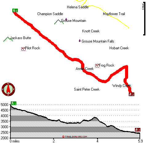
Trailhead 1 to Trailhead 2:
Total hiking length = 5.9 miles
Total climbing distance = 1 miles
Difficulty : Easy
Casual Hiking Pace: 4.5 hours
Fast Hiking Pace: 2.5 hours

Trailhead 2 to Trailhead 1:
Total hiking length = 5.9 miles
Total climbing distance = 4.1 miles
Difficulty : Difficult
Casual Hiking Pace: 6 hours
Fast Hiking Pace: 3.5 hours
    Trailhead 1 back to Trailhead 1:
Total hiking length = 11.8 miles
Total climbing distance = 5.1 miles
Difficulty : Difficult
Casual Hiking Pace: 2 days
Fast Hiking Pace: 7 hours

Trailhead 2 back to Trailhead 2:
Total hiking length = 11.8 miles
Total climbing distance = 5.1 miles
Difficulty : Difficult
Casual Hiking Pace: 2 days
Fast Hiking Pace: 7 hours

Total elevation difference: 2985 feet


Best Western Oakridge Inn, Oakridge
13 miles away
This Oakridge, Oregon hotel offers a complimentary continental breakfast each morning and convenient access to a variety of outdoor activities. Discover the Best Western Oakridge Inn, nestled agains...
  
Moonstone Village Green Resort, Cottage Grove
31 miles away
Village Green Resort is located off Interstate 5, in Cottage Grove. The resort is six miles from the covered bridges, and approximately 30 miles from Eugene Airport. We are less than a mile from two g...
User input for Steamboat Trail, Central Cascade Range, Lane County, Oregon:

Submit Input:
Your Name:
Write or Paste Input here:

Upload picture:      Review Guidelines


Outdoors Recreation Near Eugene-Springfield, Oregon
Very comprehensive list of a variety of outdoors recreation in the vicinity of Eugene-Springfield, Oregon, the metro area neareast to Steamboat Trail. Find info on campgrounds, hiking trails, ski resorts, lakes, beaches, parks, whitewater and more.

Current weather conditions at Steamboat Trail, Central Cascade Range, Lane County, Oregon
WXPort

Local climate location: DORENA DAM 5 miles away

Comfort Inn Cottage Grove, Cottage Grove
32 miles away
Pet accommodation: 10.00/night....

Holiday Inn Express Cottage Grove, Or, Cottage Grove
32 miles away
Welcome to the Holiday Inn Express in Cottage Grove.We are conveniently located in the Willamette Valley 30 miles south of Eugene just off I-5 at exit 174.We offer a free Continental Breakfast, an ind...

More Hotels and Campgrounds Near Steamboat Trail, Central Cascade Range, Lane County, Oregon

OTHER_INFO
  Central Cascade Range Campgrounds
Complete list of all the campgrounds in the Central Cascade Range.

Central Cascade Range Outdoors Info
Complete outdoors info for the Central Cascade Range.

Oregon Hiking Trails
Complete list of all hiking trails in Oregon

Books about hiking trails in Oregon
List of books available on Amazon.com about hiking trails in Oregon.

Oregon Outdoors Index
This is a very comprehensive index of outdoors activities in the great state of Oregon.


TOPO
High quality water resistant topo map of Steamboat Trail, Central Cascade Range, Lane County, Oregon.

OUTDOORS_GUIDE
These outdoors activities are available near Steamboat Trail.
 Trails Near Steamboat Trail:
Mayflower Trail, Lane County County , 1 miles away,  4.4 hiking miles, 1953 feet elevation difference
Skeeter Camp Trail, Lane County County , 4 miles away, 2.4 hiking miles, 1108 feet elevation difference
Canton Creek Trail, Lane County County , 6 miles away,  7 hiking miles, 2981 feet elevation difference
Bohemia Trail, Douglas County County , 7 miles away, 3.8 hiking miles, 1520 feet elevation difference
Holland Meadows Trail, Lane County County , 7 miles away, 1.4 hiking miles, 603 feet elevation difference
Grass Mountain Trail, Lane County County , 8 miles away, 0.6 hiking miles, 341 feet elevation difference
China Creek Trail, Lane County County , 8 miles away, 1.5 hiking miles, 992 feet elevation difference
 Camp Grounds Near Steamboat Trail:
Slim Chance Campground, Douglas County, 8 miles away
Errin Campground, Lane County, 12 miles away
Oakridge Mobile Home Park, Oakridge, 13 miles away
River View RV Park, Idleyld Park, 13 miles away
Oakridge RV Park, Oakridge, 14 miles away
 Whitewater Near Steamboat Trail:
Brice Creek, Lane County County , 3 miles away, Class IV-V - 4.5 miles long (Parker Falls to Champion Creek)
Champion Creek, Lane County County , 4 miles away, Class IV-V - 1.1 miles long (Gorge 1 mile above Brice Creek to Brice Creek)
Brice Creek, Lane County County , 6 miles away, Class IV-V - 5 miles long (Champion Creek to Cedar Creek Campground)
Steamboat Creek, Douglas County County , 10 miles away, Class II+(IV) - 9.5 miles long (City Creek to Steamboat Falls)
Steamboat Creek, Douglas County County , 11 miles away, Class IV - 6 miles long (Steamboat Falls to Canton Creek Campground)
 National Parks Near Steamboat Trail:
Crater Lake National Park, Crater Lake - OR , 47 miles away
 Hotels Near Steamboat Trail:
Best Western Oakridge Inn, Oakridge , 13 miles away
Cascade Motel & Storage, Oakridge , 13 miles away
Steamboat Inn, Idleyld Park , 14 miles away
Oakridge Motel, Oakridge , 14 miles away
Arbor Inn, Oakridge , 14 miles away
 Lakes Near Steamboat Trail
Crystal Lake, Lane County , 2 miles away
Lake Murphy, Lane County , 3 miles away

Outdoors related information copyright © Stratus-Pikpuk, Inc. - Detailed hotel information copyright © Interactive Hotel Solutions