| |
There are two trailheads to chose from, one in each end which means you have the option of trekking it one way if you have someone to pick you up at the other end. The total elevation difference for this hiking trail is 2,524 feet which is higher than average. At parts of the year this area sees very little rain, so do check for current fire restrictions before you go if you plan to bring a stove or make a camp fire. This is a long backcountry hiking trail, so make sure you bring plenty of supplies. This backcountry hiking trail goes through some very different elevations, so keep in mind that you may need to dress differently at different elevations. Now, this is roughly a 3-day backcountry trek, so make sure you've got all your overnight gear packed. Being 18.2 miles long; it's a long backcountry hiking trail.
|
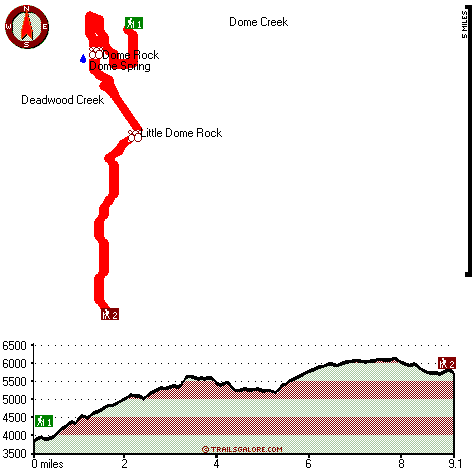
Trailhead 1 to Trailhead 2:
Total hiking length = 9.1 miles
Total climbing distance = 5.3 miles
Difficulty : Difficult
Casual Hiking Pace:
9 hours
Fast Hiking Pace:
5 hours
Trailhead 2 to Trailhead 1:
Total hiking length = 9.1 miles
Total climbing distance = 3.1 miles
Difficulty : Difficult
Casual Hiking Pace:
7.5 hours
Fast Hiking Pace:
4 hours
| | Trailhead 1 back to Trailhead 1:
Total hiking length = 18.2 miles
Total climbing distance = 8.4 miles
Difficulty : Difficult
Casual Hiking Pace:
3 days
Fast Hiking Pace:
2 days
Trailhead 2 back to Trailhead 2:
Total hiking length = 18.2 miles
Total climbing distance = 8.4 miles
Difficulty : Difficult
Casual Hiking Pace:
3 days
Fast Hiking Pace:
2 days
|
Total elevation difference: 2524 feet
|


