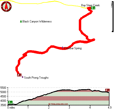
Oregon hiking trails - South Prong Trail, Blue Mountains, Grant County

   
  South Prong Trail is in a quite uninhabited area, and hiking is such an amusing thing to do, and this is an excellent site to do that. Backcountry backpacking here in Oregon is a must. Here in the good state of Oregon backcountry backpacking is a splendid way to spend some time. There are two trailheads to chose from, one in each end, so hiking it one way is an option if you can arrange for a ride back. There are numerous backpacking trails in Oregon, and each one is worth backcountry backpacking. South Prong Trail has a total elevation difference of 2,147
    feet, and that is about average. Wilderness hiking trails are good and plentiful in Oregon; South Prong Trail in Grant County is one of them. This area does get very dry sometimes, so make sure you check current conditions and fire restrictions with local forest authorities before
you head out. South Prong Trail is 9.8 miles long; it's longer than many wilderness trails. The length of this great outdoors hiking trail is on the longer side with an average amount of climbing distance which makes this hiking and backpacking trail glorious for hard core backpackers looking for adventure. Don’t forget to check for any current restrictions or closures before you go. The time needed for this backcountry trek is roughly 8.5 hours, but you never know stuff could go wrong and you could get stuck so be prepared for that. It is very dried up here  
at South Prong Trail regularly; during the month of November you get the most rain around here, and September meanwhile is the driest month. Summertime highs at South Prong Trail generally tend to be in the 80's. For the duration of the moonlight hours it's commonly in the 40's. For the duration of the winter this location gets highs in the 30's while the cold winter nights at South Prong Trail are in the 10's. You can't spend all your time indoors you need to get out once in a while, and South Prong Trail in Grant County, Oregon is a really splendid site to spend some time. South Prong Trail goes through some very different elevations, and that means that some parts of the wilderness trail could be very different from other parts of it. Backcountry backpacking here in the Blue Mountains is a really fine way to spend quality time in the fresh air. The number of hiking and backpacking trails in this vicinity is not very high. Now this great outdoors hiking trail is pretty long, so don't forget to pack enough supplies.

Briefly about the general area:
Yeah, come here to South Prong Trail for a great time. John Day Fossil Beds National Monument is a very nice place to stop at right next door to South Prong Trail. Why not camp at Fish House Inn since you're here at South Prong Trail, and South Prong Troughs is an inspiring spot to stop at while you're here.
A trip to South Prong Trail wouldn't be complete without taking a look at Crowbar Spring; it's a good idea to check out Payten Creek. Not enough hours in a day to enjoy the Blue Mountains. A pleasant place to camp here at South Prong Trail is Pine Tree Campground, and a pleasant tour to Honeymoon Basin is a great way to spend an afternoon. Big Bedground is a lovely place any time of year, and don't forget to take a splendid little journey to Bay Steer Creek.

Location of Trailhead 1: Latitude 44.3434, Longitude -119.6202
- - Directions and Road Map

Location of Trailhead 2: Latitude 44.3117, Longitude -119.655
- - Directions and Road Map


Trailhead 1 to Trailhead 2:
Total hiking length = 4.9 miles
Total climbing distance = 2.9 miles
Difficulty : Medium
Casual Hiking Pace: 5 hours
Fast Hiking Pace: 2.5 hours

Trailhead 2 to Trailhead 1:
Total hiking length = 4.9 miles
Total climbing distance = 1.2 miles
Difficulty : Easy
Casual Hiking Pace: 4 hours
Fast Hiking Pace: 2 hours
    Trailhead 1 back to Trailhead 1:
Total hiking length = 9.8 miles
Total climbing distance = 4.1 miles
Difficulty : Difficult
Casual Hiking Pace: 8.5 hours
Fast Hiking Pace: 5.5 hours

Trailhead 2 back to Trailhead 2:
Total hiking length = 9.8 miles
Total climbing distance = 4.1 miles
Difficulty : Difficult
Casual Hiking Pace: 8.5 hours
Fast Hiking Pace: 5.5 hours

Total elevation difference: 2147 feet


Americas Best Value Inn, John Day
47 miles away
The Americas Best Value Inn is centrally located in the heart of John Day, Oregon. Our charming two story outside corridor facility offers 40 spacious guest rooms with a city view. We have a Mexican R...
  
Best Western John Day Inn, John Day
47 miles away
This charming John Day, Oregon hotel is minutes from a variety of outdoor activities and walking distance from many local shops and restaurants. Located in Eastern Oregon's beautiful John Day Valley...
User input for South Prong Trail, Blue Mountains, Grant County, Oregon:

Submit Input:
Your Name:
Write or Paste Input here:

Upload picture:      Review Guidelines


Outdoors Recreation Near Prineville, Oregon
Very comprehensive list of a variety of outdoors recreation in the vicinity of Prineville, Oregon, the metro area neareast to South Prong Trail. Find info on campgrounds, hiking trails, ski resorts, lakes, beaches, parks, whitewater and more.

Current weather conditions at South Prong Trail, Blue Mountains, Grant County, Oregon
WXPort

Local climate location: PAULINA 12 miles away


More Hotels and Campgrounds Near South Prong Trail, Blue Mountains, Grant County, Oregon

OTHER_INFO
  Blue Mountains Campgrounds
Complete list of all the campgrounds in the Blue Mountains.

Blue Mountains Outdoors Info
Complete outdoors info for the Blue Mountains.

Oregon Hiking Trails
Complete list of all hiking trails in Oregon

Books about hiking trails in Oregon
List of books available on Amazon.com about hiking trails in Oregon.

Oregon Outdoors Index
This is a very comprehensive index of outdoors activities in the great state of Oregon.


TOPO
High quality water resistant topo map of South Prong Trail, Blue Mountains, Grant County, Oregon.

OUTDOORS_GUIDE
These outdoors activities are available near South Prong Trail.
 Trails Near South Prong Trail:
Black Canyon Trail, Wheeler County County , 2 miles away, 8.1 hiking miles, 3351 feet elevation difference
Coffeepot Trail, Wheeler County County , 4 miles away,  1.8 hiking miles, 887 feet elevation difference
Owl Creek Trail, Wheeler County County , 6 miles away,  1 hiking miles, 301 feet elevation difference
 Camp Grounds Near South Prong Trail:
Pine Tree Campground, Grant County, 6 miles away
Fish House Inn, Dayville, 10 miles away
Little Summit Campground, Wheeler County, 18 miles away
Lepage Park - John Day Fossil Beds National Monument, Kimberly, 18 miles away
 National Parks Near South Prong Trail:
John Day Fossil Beds National Monument, Kimberly - OR , 18 miles away
 Hotels Near South Prong Trail:
Americas Best Value Inn, John Day , 47 miles away
Best Western John Day Inn, John Day , 47 miles away
 Lakes Near South Prong Trail
Dry Gulch Reservoir, Grant County , 1 miles away
Squaw Creek Reservoir, Grant County , 1 miles away

Outdoors related information copyright © Stratus-Pikpuk, Inc. - Detailed hotel information copyright © Interactive Hotel Solutions