| |
|
| | Here in the great state of Oregon hiking is something that is always fun to do. There are great outdoors trails all over Oregon; one of those is South Fork Trail in Klamath County. Every Oregon great outdoors trail has its own character. Please follow all local rules about fires and camping. Now, this is roughly a 2-day backcountry walk, so it's a great thing if your backpack is big enough to do the job. This neighborhood does get very dry sometimes, so make sure you check current conditions and fire restrictions with local forest authorities before you |
|
head out. South Fork Trail is quite long, so don't forget to pack enough supplies. The yearly rain here at South Fork Trail is about average; most of the rain falls through November while July is the month with the least amount of precipitation. There are two trailheads to chose
| | from, one in each end, so backcountry trekking it one way is an option if you can arrange for a ride back. Summertime highs at South Fork Trail regularly tend to be in the 80's, and throughout summer nights temperatures are in the 40's. During the winter this location gets highs in the 40's, and winter nights come with lows in the 20's to South Fork Trail. The length of South Fork Trail is on the longer side with an average amount of climbing distance which makes this hiking trail great for hard core backpackers looking for adventure. South Fork Trail | |
|
has a total elevation difference of 1,813 feet which is an average number. Can’t wait to get out in the outdoors, South Fork Trail in Klamath County, Oregon is the outdoors at its best. Being 14.8 miles long; it's a long wilderness trail. Backcountry hiking here in the Southern
Cascade Range is a nice way to explore these mountains. This is an area covered with lots of hiking trails. South Fork Trail is a trail rather far from Klamath Falls, but it is a fun site to walk. Some parts of this wilderness trail are much higher up than other parts of the wilderness
trail which of course means you need to be prepared for different conditions on different parts of the wilderness trail. Backcountry hiking in Oregon is such a nice thing to do.
Briefly about the general area: Swan Creek is a beautiful stream that is worth visiting,
and a pleasant journey to McKee Basin is a nice way to spend an afternoon. Paddling on Rogue River - North Fork is so much fun, and a journey to Gypsy Spring will fill your soul with fine feelings. You just can't picture the amount of outdoors entertaining things the Southern
Cascade Range has to offer. Whohoo, so many exciting things in one place! The Southern Cascade Range is peerless! Stay the night at Saddle Campground It's always perfect to check out Dole Spring. This is no location for people who don’t like to enjoy themselves. Don't forget to
take a good little journey to Parker Creek, and naturally, all our national parks are great spots to pop by and Crater Lake National Park is no exception. Buck Basin is a great location to stretch your legs a bit. You'll need more than a day to discover everything South Fork Trail has to offer, you can camp at Upper South Fork Campground.
|
|
Location of Trailhead 1: Latitude 42.5799, Longitude -122.2864 - - Directions and Road Map
Location of Trailhead 2: Latitude 42.5325, Longitude -122.2955 - - Directions and Road Map

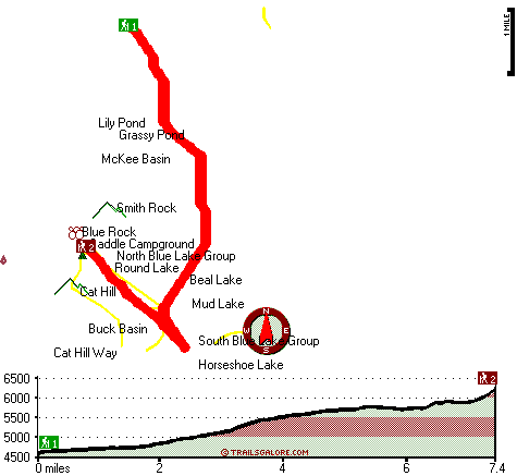
Trailhead 1 to Trailhead 2: Total hiking length = 7.4 miles Total climbing distance = 5.1 miles Difficulty : Difficult Casual Hiking Pace:
8 hours
Fast Hiking Pace:
4.5 hours
Trailhead 2 to Trailhead 1: Total hiking length = 7.4 miles Total climbing distance = .7 miles Difficulty : Difficult Casual Hiking Pace:
5 hours
Fast Hiking Pace:
2.5 hours
| | Trailhead 1 back to Trailhead 1: Total hiking length = 14.8 miles Total climbing distance = 5.8 miles Difficulty : Difficult Casual Hiking Pace:
2 days
Fast Hiking Pace:
8 hours
Trailhead 2 back to Trailhead 2: Total hiking length = 14.8 miles Total climbing distance = 5.8 miles Difficulty : Difficult Casual Hiking Pace:
2 days
Fast Hiking Pace:
8 hours
|
Total elevation difference: 1813 feet

Lithia Springs Resort And Gardens, Ashland
|
27 miles away
Hello, from Ashland, Oregon Imagine, at the end of a long day's travel, relaxing in a 2 person whirlpool tub filled with hot mineral water, right in your own room. Let the relaxing quality of the min...
|
| |
Windmill Inn And Suites Of Ashland, Ashland
|
32 miles away
Discover one of the Northwests most luxurious inns. Escape civilizations cares without leaving its pleasures behind. Come and enjoy the quiet side of Ashland. All suite hotel with magnificent panora...
|
|
User input for South Fork Trail, Southern Cascade Range, Klamath County, Oregon:

Outdoors Recreation Near Klamath Falls, Oregon Very comprehensive list of a variety of outdoors recreation in the vicinity of Klamath Falls, Oregon, the metro area neareast to South Fork Trail. Find info on campgrounds, hiking trails, ski resorts, lakes, beaches, parks, whitewater and more.
|
Current weather conditions at South Fork Trail, Southern Cascade Range, Klamath County, Oregon

Local climate location: PROSPECT 5 miles away

           
| |
Holiday Inn Express Hotel & Suites ASHLAND, Ashland
|
32 miles away
The Holiday Inn Express Hotel & Suites in Ashland is the gateway to your Oregon adventure. Our hotel features a warm, elegant environment. Conveniently placed near all of Ashland's attractions includi...
|
Super 8 Ashland, Ashland
|
32 miles away
Super 8 Ashland, Oregon is AAA Approved, 100 per cent Non Smoking Rooms, convenient to I-5 adjacent Exit 14. We Have Wireless High Speed Internet, An Indoor Heated Pool, SuperStart breakfast, Micro-F...
|
|
More Hotels and Campgrounds Near South Fork Trail, Southern Cascade Range, Klamath County, Oregon
| |
| |
 |
|
| These outdoors activities are available near South Fork Trail. |
| | Trails Near South Fork Trail:
 |
Blue Canyon Trail, Klamath County
County
, 2 miles away, 10 hiking miles, 763 feet elevation difference |
 |
Cat Hill Way, Jackson County
County
, 2 miles away, 4.5 hiking miles, 2014 feet elevation difference |
 |
Blue Rock Trail, Klamath County
County
, 3 miles away, 7.6 hiking miles, 925 feet elevation difference |
 |
Red Lake Trail, Klamath County
County
, 3 miles away, 10.3 hiking miles, 1759 feet elevation difference |
 |
Wickiup Trail, Klamath County
County
, 4 miles away, 12.4 hiking miles, 2089 feet elevation difference |
 |
Twin Ponds Trail, Klamath County
County
, 4 miles away, 5.1 hiking miles, 1377 feet elevation difference |
 |
Hemlock Lake Trail, Klamath County
County
, 4 miles away, 10.4 hiking miles, 2410 feet elevation difference |
|
| | Whitewater Near South Fork Trail:
 |
Rogue River - North Fork, Jackson County
County
, 19 miles away, Class IV(V+) - 3.3 miles long (Mill Creek Falls to Lost Creek Lake) |
 |
Rogue River - North Fork, Jackson County
County
, 19 miles away, Class III - 6 miles long (River Bridge to North Fork Park) |
 |
Rogue River - North Fork, Jackson County
County
, 22 miles away, Class IV - 3 miles long (Natural Bridge to Woodruff Bridge) |
 |
Big Butte Creek, Jackson County
County
, 23 miles away, Class III-IV - 9.5 miles long (Butte Falls to Netherlands Road) |
 |
Jenny Creek, Jackson / Siskiyou County
County
, 26 miles away, Class IV-V+ - 14 miles long (Ashland Oregon to Iron Gate Reservoir California) |
|
| | Hotels Near South Fork Trail:
 |
Lithia Springs Resort And Gardens, Ashland
, 27 miles away |
 |
Windmill Inn And Suites Of Ashland, Ashland
, 32 miles away |
 |
Holiday Inn Express Hotel & Suites ASHLAND, Ashland
, 32 miles away |
 |
Super 8 Ashland, Ashland
, 32 miles away |
 |
Ashland Motel, Ashland
, 34 miles away |
|
|
|
 |
|