Oregon hiking trails - Sourgrass Trail, Central Cascade Range, Lane County

   
  Oregon has plenty of magnificent wilderness hiking trails, and Sourgrass Trail in Lane County is one of them. Put on your backcountry backpacking shoes, and hit the backcountry hiking trail, Sourgrass Trail in Lane County, Oregon is just what you need. Here in Oregon hiking is the magnificent thing to do. Sourgrass Trail is not that long but you should still bring some emergency supplies just in case something happens. There's not much difference in elevation along the hiking and backpacking trail, so you get pretty much the same conditions along the
    whole hiking and backpacking trail. At parts of the year this vicinity sees very little rain, so do check for current fire restrictions before you go if you plan to bring a stove or make a camp fire. Pretty far from Eugene-Springfield you find Sourgrass Trail, but many people like
to trek here to be right next door to the great outdoors. There are numerous wilderness hiking trails in Oregon, and each one is well worth a walk. Sourgrass Trail is a two ended backpacking trail with two trailheads which means you have the option of trekking it one way if you have someone to pick you up at the other end. This part of Oregon is always a diversion to stop by during trekking season. This wilderness trail is on the short side having an average number of uphill miles which makes it a fine wilderness hiking trail for the average person looking  
for a fine adventure. This is one of a very small number of wilderness hiking trails in this area. Trails like this one here in the Central Cascade Range are a tremendous way to explore these highlands. And keep in mind that there could be temporary safety restrictions in place. With its 3.6 miles of walking distance it's a shorter type backcountry hike. The warmest time of the year at Sourgrass Trail arrives with high temperatures in the 80's. Through the moonlight hours it's typically in the 50's. Through the winter highs are in the 40's with winter lows in the 30's overnight here at Sourgrass Trail. Sourgrass Trail has a total elevation difference of 911 feet, and that is lower than average. This backcountry walk shouldn't take more than 3 hours, but you never know stuff could go wrong and you could get stuck so be prepared for that. All the water falling down from the sky makes Sourgrass Trail a wet place; November is when you get the most rain here, and the driest month is July.

Briefly about the general area:
Get your pulse rate up on the glorious whitewater of Fall Creek; there's whitewater on Willamette River - Middle Fork for all you adrenaline kick people. So much entertaining stuff in the Central Cascade Range, just remarkable. Cabin Creek is in the neighborhood of Sourgrass Trail and is always a pleasure to check out, and if you came to camp Errin Campground is a magnificent site to do that.
Some close by water includes Monterica Creek. There's so much to do here at Sourgrass Trail that you need to camp here for a while, Casey's Riverside Park is a brilliant spot for that.

Location of Trailhead 1: Latitude 43.8562, Longitude -122.5503
- - Directions and Road Map

Location of Trailhead 2: Latitude 43.8462, Longitude -122.5689
- - Directions and Road Map


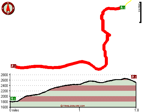
Trailhead 1 to Trailhead 2:
Total hiking length = 1.8 miles
Total climbing distance = 1.2 miles
Difficulty : Medium
Casual Hiking Pace: 2 hours
Fast Hiking Pace: 1 hours

Trailhead 2 to Trailhead 1:
Total hiking length = 1.8 miles
Total climbing distance = .3 miles
Difficulty : Easy
Casual Hiking Pace: 1.5 hours
Fast Hiking Pace: .5 hours
    Trailhead 1 back to Trailhead 1:
Total hiking length = 3.6 miles
Total climbing distance = 1.5 miles
Difficulty : Medium
Casual Hiking Pace: 3 hours
Fast Hiking Pace: 2 hours

Trailhead 2 back to Trailhead 2:
Total hiking length = 3.6 miles
Total climbing distance = 1.5 miles
Difficulty : Medium
Casual Hiking Pace: 3 hours
Fast Hiking Pace: 2 hours

Total elevation difference: 911 feet


Best Western Oakridge Inn, Oakridge
7 miles away
This Oakridge, Oregon hotel offers a complimentary continental breakfast each morning and convenient access to a variety of outdoor activities. Discover the Best Western Oakridge Inn, nestled agains...
  
Comfort Inn & Suites Creswell, Creswell
31 miles away
Welcome to the Comfort Inn and Suites of Creswell. This hotel is close to a golf course and is within walking distance of shops and restaurants. We are just a short drive to rivers, lakes and other ou...
User input for Sourgrass Trail, Central Cascade Range, Lane County, Oregon:

Submit Input:
Your Name:
Write or Paste Input here:

Upload picture:      Review Guidelines


Outdoors Recreation Near Eugene-Springfield, Oregon
Very comprehensive list of a variety of outdoors recreation in the vicinity of Eugene-Springfield, Oregon, the metro area neareast to Sourgrass Trail. Find info on campgrounds, hiking trails, ski resorts, lakes, beaches, parks, whitewater and more.

Current weather conditions at Sourgrass Trail, Central Cascade Range, Lane County, Oregon
WXPort

Local climate location: LEABURG 14 miles away

Super 8 Creswell/South Eugene, Creswell
32 miles away
Conveniently located on I-5 at Exit, 182, our Super 8 is AAA approved. We have a friendly staff and are also Pet Friendly. We offer a SuperStart Breakfast, Free High Speed Wirelless Internet, an Out...

Village Inn, Springfield
32 miles away
The Village Inn Springfield Oregon is your ideal choice for Springfield Oregon hotels. The Village Inn provides lodging near the University of Oregon, Autzen Stadium, Downtown Eugene and just blocks a...

More Hotels and Campgrounds Near Sourgrass Trail, Central Cascade Range, Lane County, Oregon

OTHER_INFO
  Central Cascade Range Campgrounds
Complete list of all the campgrounds in the Central Cascade Range.

Central Cascade Range Outdoors Info
Complete outdoors info for the Central Cascade Range.

Oregon Hiking Trails
Complete list of all hiking trails in Oregon

Books about hiking trails in Oregon
List of books available on Amazon.com about hiking trails in Oregon.

Oregon Outdoors Index
This is a very comprehensive index of outdoors activities in the great state of Oregon.


TOPO
High quality water resistant topo map of Sourgrass Trail, Central Cascade Range, Lane County, Oregon.

OUTDOORS_GUIDE
These outdoors activities are available near Sourgrass Trail.
 Trails Near Sourgrass Trail:
Cabin Creek Trail, Lane County County , 1 miles away, 2.1 hiking miles, 1792 feet elevation difference
Cloverpatch Trail, Lane County County , 1 miles away, 3.3 hiking miles, 1327 feet elevation difference
Tire Mountain Trail, Lane County County , 4 miles away, 2.4 hiking miles, 722 feet elevation difference
 Camp Grounds Near Sourgrass Trail:
Casey's Riverside Park, Westfir, 5 miles away
Errin Campground, Lane County, 6 miles away
Oakridge Mobile Home Park, Oakridge, 8 miles away
Oakridge RV Park, Oakridge, 9 miles away
Upper End Campground, Lane County, 10 miles away
 Whitewater Near Sourgrass Trail:
Willamette River - Middle Fork, Lane County County , 7 miles away, Class II - 12.5 miles long (Hills Creek Dam to Lookout Point Reservoir)
Fall Creek, Lane County County , 7 miles away, Class III-IV - 8 miles long (Portland Creek to Fall Creek Reservoir)
Winberry Creek, Lane County County , 7 miles away, Class III+(V) - 4 miles long (South / North Fork Confluence to Forest Service bridge)
 National Parks Near Sourgrass Trail:
Crater Lake National Park, Crater Lake - OR , 56 miles away
 Hotels Near Sourgrass Trail:
Best Western Oakridge Inn, Oakridge , 7 miles away
Comfort Inn & Suites Creswell, Creswell , 31 miles away
Super 8 Creswell/South Eugene, Creswell , 32 miles away
Village Inn, Springfield , 32 miles away
Moonstone Village Green Resort, Cottage Grove , 33 miles away

Outdoors related information copyright © Stratus-Pikpuk, Inc. - Detailed hotel information copyright © Interactive Hotel Solutions