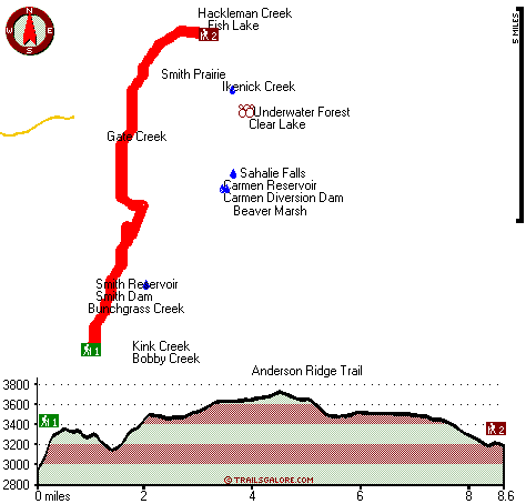
Oregon hiking trails - Smith Prairie Trail, Central Cascade Range, Linn County

   
  A long trip divides Bend from Smith Prairie Trail, but it is a really great trail. Here in Oregon backcountry trekking is something that is always fun to do. This part of Oregon has a glorious deal of available outdoors things to do. Trekking here in the Central Cascade Range is the best way to enjoy these mountains. This backcountry walk should take you about 2.5 days, so make sure you've got all your overnight gear packed. This is an area covered with lots of backpacking trails. Backpacking and hiking trails are wonderful and plentiful in Oregon,
    and one of those is Smith Prairie Trail in Linn County. During the summer here at Smith Prairie Trail, high temperatures frequently get into the 80's while overnight lows are ordinarily in the 40's. Daytime highs all through the wintertime are in the 30's, and overnight lows at
Smith Prairie Trail all through the wintertime ordinarily fall into the 20's. The backcountry trail stays roughly within the same elevation zone the whole time which means the conditions are about the same from start to finish. With its 17.2 miles of walking distance; it's longer than many backcountry trails. Smith Prairie Trail has a total elevation difference of 923 feet which is a lower than average number. Smith Prairie Trail is a wet site that gets a large amount of rainfall; December is the wettest month with most rain, and the driest month of the  
year is July. Time to get out, and breathe some fresh air, and Smith Prairie Trail in Linn County, Oregon is a great spot to go. This wilderness trail is many miles long with an average amount of climbing distance which makes this a very tough backpacking trail for advanced backcountry trekkers looking for a glorious challenge. This is a great outdoors trail that is quite long, so make sure you bring plenty of supplies. Every hiking trail in Oregon is well worth a backcountry trek. And keep in mind that there could be temporary safety restrictions in location. This great outdoors trail sometimes gets very dry, so do check for current fire restrictions before you go if you plan to bring a stove or make a camp fire. There are two trailheads to chose from, one in each end which means you have the option of backcountry backpacking it one way if you have someone to pick you up at the other end.

Briefly about the general area:
Nearby Tombstone Pass is a good place to go if you're at Smith Prairie Trail, and Lost Prairie is a perfect place to stretch your legs a bit. So many exciting things to do in the Central Cascade Range, not sufficient time. A tremendous forest next to Smith Prairie Trail is Willamette National Forest, and you can stay the night at Country Star Recreational Vehicle Park.
Tamolitch Falls is always fun to check out. There's no way anybody can get bored here in the Central Cascade Range. Paddling on Marion Creek is so much fun, and a pleasant visit to Smith Prairie is a pleasant way to spend an afternoon. You absolutely have to like Smith Prairie Trail. Tombstone Prairie Campground is a tremendous campground nearby, and some close by water includes Gate Creek.
Carmen Diversion Dam is a site that is in the vicinity of Smith Prairie Trail; whitewater paddling is wonderful on Horse Creek. Getting to Browder Creek from Smith Prairie Trail is trouble-free, and a short tour to Koosah Falls is always worthwhile.

Location of Trailhead 1: Latitude 44.2909, Longitude -122.0441
- - Directions and Road Map

Location of Trailhead 2: Latitude 44.3966, Longitude -122.0046
- - Directions and Road Map


Trailhead 1 to Trailhead 2:
Total hiking length = 8.6 miles
Total climbing distance = 3.6 miles
Difficulty : Difficult
Casual Hiking Pace: 7.5 hours
Fast Hiking Pace: 4 hours

Trailhead 2 to Trailhead 1:
Total hiking length = 8.6 miles
Total climbing distance = 3.9 miles
Difficulty : Difficult
Casual Hiking Pace: 8 hours
Fast Hiking Pace: 4.5 hours
    Trailhead 1 back to Trailhead 1:
Total hiking length = 17.2 miles
Total climbing distance = 7.5 miles
Difficulty : Difficult
Casual Hiking Pace: 2.5 days
Fast Hiking Pace: 1.5 days

Trailhead 2 back to Trailhead 2:
Total hiking length = 17.2 miles
Total climbing distance = 7.5 miles
Difficulty : Difficult
Casual Hiking Pace: 2.5 days
Fast Hiking Pace: 1.5 days

Total elevation difference: 923 feet


Lodge at Suttle Lake, Sisters
26 miles away
We are not your typical hotel. Nestled in the heart of the Deschutes National Forest amid soaring pines. Suttle Lake Resort provides an enchanted escape. Our resorts mountain views and pristine lake w...
  
Best Western Ponderosa Lodge, Sisters
32 miles away
Offers a refreshing environment with renovated rooms, new deluxe suites and smoke-free accommodations. The perfect choice while traveling the 'Gateway to the Cascades', ideally located on 14 acres sur...
User input for Smith Prairie Trail, Central Cascade Range, Linn County, Oregon:

Submit Input:
Your Name:
Write or Paste Input here:

Upload picture:      Review Guidelines


Outdoors Recreation Near Bend, Oregon
Very comprehensive list of a variety of outdoors recreation in the vicinity of Bend, Oregon, the metro area neareast to Smith Prairie Trail. Find info on campgrounds, hiking trails, ski resorts, lakes, beaches, parks, whitewater and more.

Current weather conditions at Smith Prairie Trail, Central Cascade Range, Linn County, Oregon
WXPort

Local climate location: BELKNAP SPRINGS 8 miles away

Five Pine Lodge, Sisters
34 miles away
Lodging in Sisters, Oregon, at FivePine Lodge and Spa is a vacation back in time to Central Oregon's golden era of travel with every modern luxury. Whether you're practicing Tai-Chi atop Eagle Rock, p...

Best Western Oakridge Inn, Oakridge
44 miles away
This Oakridge, Oregon hotel offers a complimentary continental breakfast each morning and convenient access to a variety of outdoor activities. Discover the Best Western Oakridge Inn, nestled agains...

More Hotels and Campgrounds Near Smith Prairie Trail, Central Cascade Range, Linn County, Oregon

OTHER_INFO
  Central Cascade Range Campgrounds
Complete list of all the campgrounds in the Central Cascade Range.

Central Cascade Range Outdoors Info
Complete outdoors info for the Central Cascade Range.

Oregon Hiking Trails
Complete list of all hiking trails in Oregon

Books about hiking trails in Oregon
List of books available on Amazon.com about hiking trails in Oregon.

Oregon Outdoors Index
This is a very comprehensive index of outdoors activities in the great state of Oregon.


TOPO
High quality water resistant topo map of Smith Prairie Trail, Central Cascade Range, Linn County, Oregon.

OUTDOORS_GUIDE
These outdoors activities are available near Smith Prairie Trail.
 Trails Near Smith Prairie Trail:
Browder Ridge Trail, Linn County County , 4 miles away, 3.6 hiking miles, 1658 feet elevation difference
Anderson Ridge Trail, Linn County County , 4 miles away, 7.5 hiking miles, 2720 feet elevation difference
Crescent Mountain Trail, Linn County County , 5 miles away,  7.8 hiking miles, 2419 feet elevation difference
Deer Butte Trail, Linn County County , 7 miles away, 8.6 hiking miles, 814 feet elevation difference
Lookout Mountain Trail, Lane County County , 8 miles away, 1.6 hiking miles, 527 feet elevation difference
Maxwell Trail, Linn County County , 9 miles away,  8.4 hiking miles, 2511 feet elevation difference
Pocket Way, Linn County County , 9 miles away,  3.2 hiking miles, 166 feet elevation difference
 Camp Grounds Near Smith Prairie Trail:
Tombstone Prairie Campground, Linn County, 8 miles away
Country Star Recreational Vehicle Park, Foster, 9 miles away
Patio RV Park, Blue River, 14 miles away
Holiday Farm RV Resort, Blue River, 16 miles away
Echo Campground, Lane County, 18 miles away
 Whitewater Near Smith Prairie Trail:
Horse Creek, Lane County County , 11 miles away, Class III - 11 miles long (above Separation Creek to McKenzie River)
Marion Creek, Linn County County , 15 miles away, Class IV(V) - 7 miles long (Gooch Falls)
Blue River, Linn/ Lane County County , 16 miles away, Class IV-V - 4 miles long (Quentin Creek to Blue River Reservoir)
Lookout Creek, -blank- County County , 17 miles away, Class III-IV - 2.5 miles long (2.5 miles above Blue River to Blue River)
Santiam River - North, Marion/ Linn County County , 18 miles away, Class III-IV - 7.3 miles long (Bruno Mt. Road Bridge to Detroit Reservoir)
 Hotels Near Smith Prairie Trail:
Lodge at Suttle Lake, Sisters , 26 miles away
Best Western Ponderosa Lodge, Sisters , 32 miles away
Five Pine Lodge, Sisters , 34 miles away
Best Western Oakridge Inn, Oakridge , 44 miles away
Sunriver Resort, Sunriver , 46 miles away
 Lakes Near Smith Prairie Trail
Smith Reservoir, Linn County , 2 miles away
Clear Lake, Linn County , 3 miles away

Outdoors related information copyright © Stratus-Pikpuk, Inc. - Detailed hotel information copyright © Interactive Hotel Solutions