| |
This hiking and backpacking trail has two trailheads, so if you can get a ride from someone, you can trek it just one way. This region does get very dry sometimes, so make sure you check current conditions and fire restrictions with local forest authorities before you head out. This hiking and backpacking trail has a total elevation difference of 243 feet which is lower than average. With its 4.8 miles of walking distance it's a mid length hike. This is not a very long backcountry trail but you should still bring some emergency supplies just in case something happens. The great outdoors hiking trail stays roughly within the same elevation zone the whole time which means the conditions are about the same from start to finish. This backcountry hike shouldn't take more than 4 hours, but of course some folks walk a bit slower and some a bit faster.
|
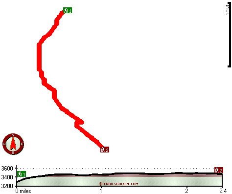
Trailhead 1 to Trailhead 2:
Total hiking length = 2.4 miles
Total climbing distance = 1.2 miles
Difficulty : Medium
Casual Hiking Pace:
2 hours
Fast Hiking Pace:
1 hours
Trailhead 2 to Trailhead 1:
Total hiking length = 2.4 miles
Total climbing distance = .8 miles
Difficulty : Medium
Casual Hiking Pace:
2 hours
Fast Hiking Pace:
1 hours
| | Trailhead 1 back to Trailhead 1:
Total hiking length = 4.8 miles
Total climbing distance = 2 miles
Difficulty : Medium
Casual Hiking Pace:
4 hours
Fast Hiking Pace:
2.5 hours
Trailhead 2 back to Trailhead 2:
Total hiking length = 4.8 miles
Total climbing distance = 2 miles
Difficulty : Medium
Casual Hiking Pace:
4 hours
Fast Hiking Pace:
2.5 hours
|
Total elevation difference: 243 feet
|


