| |
|
| | Trekking here in Oregon is so much fun. There are numerous backcountry trails in Oregon, and each one is picturesque in its own way. Great outdoors trails are fine and plentiful in Oregon, and Silver Butte Trail in Grant County is one of them. The great outdoors hiking trails of the Blue Mountains are a really wonderful way to spend quality time in the wilderness. 
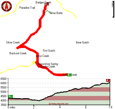
The total elevation difference for this backpacking and hiking trail is 2,246 feet which is about average. This is one of many hiking trails in the surrounding area. Throughout the warmest |
|
time of the year, highs typically are in the 80's at Silver Butte Trail, and throughout summer nights temperatures are in the 30's. For the duration of the wintertime the highs are mostly in the 30's while the cold winter nights at Silver Butte Trail are in the 10's. While visiting
| | this vicinity in Oregon it's a perfect idea to go hiking too. Now, this is roughly a 2.5-day hike, so it's a good thing if your backpack is big enough to do the job. Around Silver Butte Trail you don’t get a lot of precipitation; most of the rain falls through November, and July is the month with the least moisture. Some parts of Silver Butte Trail are much higher up than other parts of the backcountry trail, so keep in mind that you may need to dress differently at different elevations. Silver Butte Trail is to be found a pretty long drive from La Grande, | |
|
but it is one of many good hiking trails in this area. Time to get out, and breathe some fresh air, and Silver Butte Trail in Grant County, Oregon is a really good place to spend some time. At parts of the year this region sees very little rain, so don’t forget to check for any
current fire restrictions before you go. This is a two-ended backpacking and hiking trail with two trailheads which means you have the option of trekking it one way if you have someone to pick you up at the other end. This great outdoors hiking trail is a very long great outdoors
hiking trail having an average number of uphill miles which makes this hiking trail fine for hard core backpackers looking for adventure. Please follow all local rules about fires and camping. With its 15.6 miles of walking distance; it's a long backcountry trail. Now this hiking
trail is pretty long, so do pack enough food to last the whole trip.
Briefly about the general area: Deerhorn Campground is a delightful local campground, and Silver Butte Trail is right next door to First Gulch which is without doubt worth taking a look at. Why not
stop by nearby Granite Creek while you're here at Silver Butte Trail, and places like China Meadow are perfect to go to. Whohoo, so many cool things in one place! Silver Butte Trail is so good! There are some great whitewater spots on John Day River - North Fork, and a short
tour to Snowshoe Spring is always worthwhile. Lake Creek is a striking stream that is worth visiting; Moon Meadow is a beautiful location any time of year. Be careful coming to the Blue Mountains, you might not ever want to return back home again. Whitewater paddling is not for
everybody but if it's for you then we recommend Grande Ronde River. Yeah, come up here to the Blue Mountains for a magnificent time. Corrigal Spring Campground is a good campground nearby, and Packsaddle Spring is an inspiring place to stop by while here.
|
|
Location of Trailhead 1: Latitude 44.8494, Longitude -118.5305 - - Directions and Road Map
Location of Trailhead 2: Latitude 44.9116, Longitude -118.5504 - - Directions and Road Map

Trailhead 1 to Trailhead 2: Total hiking length = 7.8 miles Total climbing distance = 4.6 miles Difficulty : Difficult Casual Hiking Pace:
7.5 hours
Fast Hiking Pace:
4.5 hours
Trailhead 2 to Trailhead 1: Total hiking length = 7.8 miles Total climbing distance = 2 miles Difficulty : Difficult Casual Hiking Pace:
6 hours
Fast Hiking Pace:
3.5 hours
| | Trailhead 1 back to Trailhead 1: Total hiking length = 15.6 miles Total climbing distance = 6.6 miles Difficulty : Difficult Casual Hiking Pace:
2.5 days
Fast Hiking Pace:
9 hours
Trailhead 2 back to Trailhead 2: Total hiking length = 15.6 miles Total climbing distance = 6.6 miles Difficulty : Difficult Casual Hiking Pace:
2.5 days
Fast Hiking Pace:
9 hours
|
Total elevation difference: 2246 feet

Best Western John Day Inn, John Day
|
36 miles away
This charming John Day, Oregon hotel is minutes from a variety of outdoor activities and walking distance from many local shops and restaurants. Located in Eastern Oregon's beautiful John Day Valley...
|
| |
Americas Best Value Inn, John Day
|
36 miles away
The Americas Best Value Inn is centrally located in the heart of John Day, Oregon. Our charming two story outside corridor facility offers 40 spacious guest rooms with a city view. We have a Mexican R...
|
|
User input for Silver Butte Trail, Blue Mountains, Grant County, Oregon:

Outdoors Recreation Near La Grande, Oregon Very comprehensive list of a variety of outdoors recreation in the vicinity of La Grande, Oregon, the metro area neareast to Silver Butte Trail. Find info on campgrounds, hiking trails, ski resorts, lakes, beaches, parks, whitewater and more.
More Hotels and Campgrounds Near Silver Butte Trail, Blue Mountains, Grant County, Oregon
| |
| |
 |
|
| These outdoors activities are available near Silver Butte Trail. |
| | Trails Near Silver Butte Trail:
 |
Paradise Trail, Grant County
County
, 2 miles away, 8.6 hiking miles, 2883 feet elevation difference |
 |
Blackwell Trail, Grant County
County
, 3 miles away, 7.6 hiking miles, 2286 feet elevation difference |
 |
Lake Creek Trail, Grant County
County
, 3 miles away, 8.7 hiking miles, 2647 feet elevation difference |
 |
Indian Trail, Grant County
County
, 3 miles away, 6.7 hiking miles, 1314 feet elevation difference |
 |
Wagner Gulch Trail, Grant County
County
, 3 miles away, 5.6 hiking miles, 2158 feet elevation difference |
 |
Trout Meadows Trail, Grant County
County
, 4 miles away, 3.7 hiking miles, 508 feet elevation difference |
 |
Chinaman Trail, Grant County
County
, 4 miles away, 3.2 hiking miles, 237 feet elevation difference |
|
| | Whitewater Near Silver Butte Trail:
 |
John Day River - North Fork, Grant/ Umatilla County
County
, 9 miles away, Class II-III - 41 miles long (Route 52 Bridge to Dale) |
 |
Grande Ronde River, Union County
County
, 21 miles away, Class II-IV - 17 miles long (Tony Vey Meadow to Red Bridge State Park) |
 |
Grande Ronde River, Union County
County
, 28 miles away, Class II - 8 miles long (Red Bridge State Park to Hilgard Junction State Park) |
|
| | Hotels Near Silver Butte Trail:
 |
Best Western John Day Inn, John Day
, 36 miles away |
 |
Americas Best Value Inn, John Day
, 36 miles away |
 |
Rugged Country Lodge DBA Double H Investments, Pendleton
, 38 miles away |
 |
Rodeway Inn La Grande, La Grande
, 38 miles away |
 |
La Grande Travelodge, La Grande
, 39 miles away |
|
|
|
 |
|