Oregon hiking trails - Scorpion Ridge Trail, Central Cascade Range, Marion County

   
  Can’t wait to get out in the great outdoors, Scorpion Ridge Trail in Marion County, Oregon is just what you need. Here in the tremendous state of Oregon trekking is a glorious way to spend some time. Every Oregon hiking trail is well worth a trek. Oregon is a good site for outdoors people. This is a one trailhead great outdoors trail, so you're looking at an in and out walk. The high level of precipitation makes Scorpion Ridge Trail a pretty wet place; December is the wettest month with most rain, and July meanwhile is the driest month. Different parts of
    Scorpion Ridge Trail are at very different elevations, and that means that some parts of the wilderness trail could be very different from other parts of it. Great outdoors trails for trekking, and backpacking can be found all over Oregon; one of those is Scorpion Ridge Trail in
Marion County. This is one of many hiking trails in the surrounding area. You should count on this trek taking about 6.5 hours, but of course some people walk a bit slower and some a bit faster. These backcountry trails here in the Central Cascade Range are the best way to enjoy these highlands. Throughout the summer, highs frequently are in the 70's at Scorpion Ridge Trail, and through summer nights temperatures are in the 50's. During the winter the highs are frequently in the 40's with winter lows in the 30's overnight here at Scorpion Ridge Trail.  
Please follow all local rules about fires and camping. Keep in mind that this is a long hiking and backpacking trail, so don't forget to pack enough supplies. Scorpion Ridge Trail is a normal length backcountry trail with an average amount of climbing distance which makes this a very tough hiking trail for advanced backcountry trekkers looking for a good challenge. The total elevation difference for Scorpion Ridge Trail is 2,625 feet which is higher than average. This hiking and backpacking trail sometimes gets very dry, so make sure you check current conditions and fire restrictions with local forest authorities before you head out. Scorpion Ridge Trail is not very in the vicinity of Hood River at all, but hiking it is always cool. With its 7.6 miles of walking distance it's an average length wilderness trail.

Briefly about the general area:
Float down the rapids of Breitenbush River in a kayak, and some nearby water includes Minnie Boohoo Creek.
B and B Rentals is a nice local campground; if you come at the right time of year, Collawash River offers some great whitewater. So many fun things to do here in the Central Cascade Range, too great to be true. If you came for an overnight stay Detroit Lake State Park is a great place to camp; Leone Creek is in the neighborhood of Scorpion Ridge Trail and is always a bliss to take a look at.

Location of Trailhead: Latitude 44.7827, Longitude -122.0263
- - Directions and Road Map

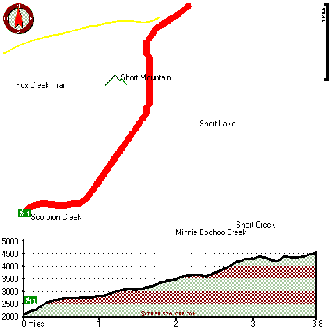
Total in and out hiking length = 7.6 miles

Total climbing distance = 3.1 miles

Difficulty : Difficult

Casual Hiking Pace: 6.5 hours

Fast Hiking Pace: 4.5 hours

Total elevation difference: 2625 feet


Whispering Woods (Vri), Welches
26 miles away
Whispering Woods is a resort destination east of Portland which opened in 1981 with 42 condominiums. The second phase of 24 additional condominiums opened in 1992. The resort offers a clubhouse with a...
  
Resort at the Mountain, Welches
26 miles away
The Resort at The Mountain is the premier Northwest golf and ski resort located in the Highlands of Oregon just an hour east of Portland at the western base of Mt. Hood. The Resort features 160 gues...
User input for Scorpion Ridge Trail, Central Cascade Range, Marion County, Oregon:

Submit Input:
Your Name:
Write or Paste Input here:

Upload picture:      Review Guidelines


Outdoors Recreation Near Hood River, Oregon
Very comprehensive list of a variety of outdoors recreation in the vicinity of Hood River, Oregon, the metro area neareast to Scorpion Ridge Trail. Find info on campgrounds, hiking trails, ski resorts, lakes, beaches, parks, whitewater and more.

Current weather conditions at Scorpion Ridge Trail, Central Cascade Range, Marion County, Oregon
WXPort

Local climate location: THREE LYNX 13 miles away

Mount Hood Inn, Government Camp
30 miles away
At the Mount Hood Inn we offer our guests the finest accommodations on the mountain. With our modern facilities and friendly local staff we are able to give you the attention and service you have com...

Lodge at Suttle Lake, Sisters
32 miles away
We are not your typical hotel. Nestled in the heart of the Deschutes National Forest amid soaring pines. Suttle Lake Resort provides an enchanted escape. Our resorts mountain views and pristine lake w...

More Hotels and Campgrounds Near Scorpion Ridge Trail, Central Cascade Range, Marion County, Oregon

OTHER_INFO
  Central Cascade Range Campgrounds
Complete list of all the campgrounds in the Central Cascade Range.

Central Cascade Range Outdoors Info
Complete outdoors info for the Central Cascade Range.

Oregon Hiking Trails
Complete list of all hiking trails in Oregon

Books about hiking trails in Oregon
List of books available on Amazon.com about hiking trails in Oregon.

Oregon Outdoors Index
This is a very comprehensive index of outdoors activities in the great state of Oregon.


TOPO
High quality water resistant topo map of Scorpion Ridge Trail, Central Cascade Range, Marion County, Oregon.

OUTDOORS_GUIDE
These outdoors activities are available near Scorpion Ridge Trail.
 Trails Near Scorpion Ridge Trail:
Fox Creek Trail, Marion County County , 2 miles away,  7.2 hiking miles, 1917 feet elevation difference
Scorpion Mountain Trail, Marion County County , 2 miles away, 0.5 hiking miles, 176 feet elevation difference
Thomas Trail, Marion County County , 2 miles away,  1.4 hiking miles, 489 feet elevation difference
East Fork Way, Marion County County , 2 miles away, 2.1 hiking miles, 913 feet elevation difference
Humbug Ridge Trail, Marion County County , 3 miles away, 6.9 hiking miles, 1523 feet elevation difference
Janus Butte Trail, Marion County County , 3 miles away,  8.2 hiking miles, 2376 feet elevation difference
Rapidan Trail, Marion County County , 5 miles away,  4.4 hiking miles, 1359 feet elevation difference
 Camp Grounds Near Scorpion Ridge Trail:
Detroit Lake State Park, -blank-, 12 miles away
B and B Rentals, Detroit, 13 miles away
Skookum Lake Campground, Clackamas County, 15 miles away
Lemiti Campground, Clackamas County, 16 miles away
Frazier Turnaround Campground, Clackamas County, 17 miles away
 Whitewater Near Scorpion Ridge Trail:
Breitenbush River, Marion County County , 5 miles away, Class IV - 8.2 miles long (Cleator Bend Campground to Detroit Lake)
Collawash River, Marion County County , 7 miles away, Class III-IV(V) - 5 miles long (Elk Lake Creek to river mile 5.5)
Santiam River - North, Marion/ Linn County County , 7 miles away, Class III-IV - 7.3 miles long (Bruno Mt. Road Bridge to Detroit Reservoir)
Collawash River, Marion County County , 10 miles away, Class IV - 5.5 miles long (Mile 5.5 bridge to Two Rivers Picnic Area)
Clackamas River, Clackamas County County , 11 miles away, Class III-IV - 8 miles long (June Creek Br. to Collawash River)
 Hotels Near Scorpion Ridge Trail:
Whispering Woods (Vri), Welches , 26 miles away
Resort at the Mountain, Welches , 26 miles away
Mount Hood Inn, Government Camp , 30 miles away
Lodge at Suttle Lake, Sisters , 32 miles away
Best Western Sandy Inn, Sandy , 35 miles away

Outdoors related information copyright © Stratus-Pikpuk, Inc. - Detailed hotel information copyright © Interactive Hotel Solutions