| |
|
| | With so many outdoors pastimes available in Oregon you'll never get bored. Backpacking here in Oregon is so much fun. There are so many fine backpacking trails for trekking in Oregon; one of them being Sawtooth Way in Douglas County. This backcountry trek shouldn't take more than 9 hours, but you never know stuff could go wrong and you could get stuck so be prepared for that. Sawtooth Way has a total elevation difference of 1,284 feet which is an average number. Every Oregon backpacking trail is different from the others. This hiking and backpacking trail |
|
sometimes gets very dry, so don’t forget to check for any current fire restrictions before you go. Backcountry backpacking here in the Central Cascade Range is a very wonderful way to see these mountains. Alright, enough of spending all this time inside a building, time to get
| | out, and Sawtooth Way in Douglas County, Oregon is such a magnificent site. A lot of rain falls at Sawtooth Way; during December this area sees the most rain; July on the other hand is the driest. You'll have to go far from Klamath Falls to get to Sawtooth Way, but if you're looking for a magnificent site to go backcountry hiking, this is a magnificent selection. This is an area covered with lots of backpacking trails. And keep in mind that there could be temporary safety restrictions in place. This is a hiking and backpacking trail that is quite long, so | |
|
don't forget to pack enough supplies. During the summertime highs here at Sawtooth Way reach the 80's, and the night is somewhat colder of course, usually in the 40's. The wintertime brings highs down to the 40's, and winter nights come with lows in the 20's to Sawtooth Way. Sawtooth
Way is 9.6 miles long; it's a long backpacking and hiking trail. This backpacking trail is many miles long with an average amount of climbing distance which makes it a magnificent backpacking trail for experienced backcountry trekkers in delightful shape. You spend the whole hike
in roughly the same elevation zone, so you won’t have to worry about different climate zones along your hike. This is a two-ended great outdoors hiking trail with two trailheads, so if you can get a ride from someone, you can backcountry walk it just one way.
Briefly about
the general area: Emigrant Pass is a splendid location to explore near Sawtooth Way, and Sawtooth Way is a brilliant place to camp, Lake Lucile Campground is a brilliant place. That right there is loads of cool things already but it goes on, the Central Cascade Range has it
all. Looking for some flowing water? Try Crystal Creek; you can stay the night at Shelter Cove Resort. This river has it all. Bradley Creek is a great local stream; Crystal Springs is an inspiring spot to check out while you're here.
|
|
Location of Trailhead 1: Latitude 43.4112, Longitude -122.1162 - - Directions and Road Map
Location of Trailhead 2: Latitude 43.3693, Longitude -122.1522 - - Directions and Road Map

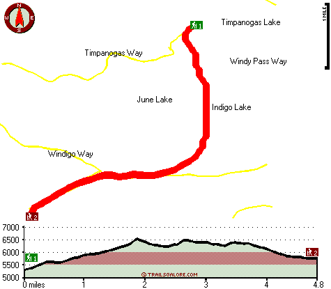
Trailhead 1 to Trailhead 2: Total hiking length = 4.8 miles Total climbing distance = 2.4 miles Difficulty : Medium Casual Hiking Pace:
4.5 hours
Fast Hiking Pace:
2.5 hours
Trailhead 2 to Trailhead 1: Total hiking length = 4.8 miles Total climbing distance = 2.1 miles Difficulty : Medium Casual Hiking Pace:
4.5 hours
Fast Hiking Pace:
2.5 hours
| | Trailhead 1 back to Trailhead 1: Total hiking length = 9.6 miles Total climbing distance = 4.5 miles Difficulty : Difficult Casual Hiking Pace:
9 hours
Fast Hiking Pace:
6 hours
Trailhead 2 back to Trailhead 2: Total hiking length = 9.6 miles Total climbing distance = 4.5 miles Difficulty : Difficult Casual Hiking Pace:
9 hours
Fast Hiking Pace:
6 hours
|
Total elevation difference: 1284 feet

Best Western Oakridge Inn, Oakridge
|
31 miles away
This Oakridge, Oregon hotel offers a complimentary continental breakfast each morning and convenient access to a variety of outdoor activities. Discover the Best Western Oakridge Inn, nestled agains...
|
| |
Best Western Newberry Station, La Pine
|
46 miles away
Stay at this La Pine, Oregon hotel, a central location to 5 of the major recreational areas in Oregon including Crater Lake and the 14 lake Cascade Lakes. Welcome to the Best Western Newberry Statio...
|
|
User input for Sawtooth Way, Central Cascade Range, Douglas County, Oregon:

Outdoors Recreation Near Klamath Falls, Oregon Very comprehensive list of a variety of outdoors recreation in the vicinity of Klamath Falls, Oregon, the metro area neareast to Sawtooth Way. Find info on campgrounds, hiking trails, ski resorts, lakes, beaches, parks, whitewater and more.
More Hotels and Campgrounds Near Sawtooth Way, Central Cascade Range, Douglas County, Oregon
| |
| |
 |
|
| These outdoors activities are available near Sawtooth Way. |
| | Trails Near Sawtooth Way:
 |
Timpanogas Way, Douglas County
County
, 1 miles away, 4 hiking miles, 432 feet elevation difference |
 |
Windigo Way, Douglas County
County
, 1 miles away, 3.2 hiking miles, 738 feet elevation difference |
 |
Windy Pass Way, Douglas County
County
, 1 miles away, 10.5 hiking miles, 1518 feet elevation difference |
 |
Kelsay Way, Douglas County
County
, 3 miles away, 6.2 hiking miles, 2161 feet elevation difference |
 |
Calamut Way, Douglas County
County
, 5 miles away, 2.7 hiking miles, 595 feet elevation difference |
 |
Windy Lakes Trail, Klamath County
County
, 6 miles away, 8 hiking miles, 1381 feet elevation difference |
 |
Fawn Lake Way, Klamath County
County
, 7 miles away, 14 hiking miles, 2081 feet elevation difference |
|
| | Hotels Near Sawtooth Way:
 |
Mazama Village Motor Inn, Crater Lake
, 25 miles away |
 |
Crater Lake Motel, Chemult
, 26 miles away |
 |
Chemult Motel, Chemult
, 26 miles away |
 |
Holiday Village Motel Trailer, Chemult
, 26 miles away |
 |
Dawson House Lodge, Chemult
, 26 miles away |
|
|
|
 |
|