| |
|
| | Put on your backcountry backpacking shoes, and hit the wilderness hiking trail, Sandstone Trail in Douglas County, Oregon is nature at its best. There are numerous hiking trails in Oregon, and each one has something unique to offer. Going for a trek here in Oregon is always an enjoyable thing to do. Keep in mind that this is a long backpacking and hiking trail, so don't forget to pack enough supplies. Sandstone Trail is a mid-length backpacking trail having an average number of uphill miles which makes it a great great outdoors hiking trail for experienced |
|
backcountry walkers in perfect shape. Sandstone Trail is located a quite lengthy journey from Medford, but you always have a nice time when you're backcountry backpacking along it. This backpacking and hiking trail has two trailheads which means you have the option of backpacking
| | it one way if you have someone to pick you up at the other end. These backpacking trails here in the Southern Cascade Range are the best way to enjoy these mountains. There are many perfect hiking trails in Oregon, and Sandstone Trail in Douglas County is one of them. All the water falling down from the sky makes Sandstone Trail a wet location; during November this area sees the most rain; the driest month of the year is July. This trek shouldn't take more than 7 hours, but you never know stuff could go wrong and you could get stuck so be prepared for that. | |
|
A visit to Oregon is not complete without some trekking. Sandstone Trail has a total elevation difference of 2,406 feet which is about average. And keep in mind that there could be temporary safety restrictions in site. Some parts of this great outdoors trail are much higher up
than other parts of the great outdoors trail, so keep in mind that you may need to dress differently at different elevations. Sandstone Trail is 7.8 miles long it's a mid length hike. This backpacking and hiking trail sometimes gets very dry, so don’t forget to check for any current
fire restrictions before you go. Summertime highs at Sandstone Trail regularly tend to be in the 80's while nighttime lows are ordinarily in the 40's. High temperatures during the wintertime are normally in the 40's, and nighttime lows in the 30's for Sandstone Trail. This is just
one of a large number of great outdoors hiking trails in this region.
Briefly about the general area: Yep, outdoors amusing stuff truly is bountiful here in the Southern Cascade Range. Rogue River - North Fork has a good whitewater paddling spot close by, and don't miss
out on a spree to Crater Lake National Park while you're here. A quick visit to Lonewoman Creek near Sandstone Trail is a nice idea; Sandstone Trail is a wonderful site to visit for more than one day, Cliff Lake Campground is a wonderful site to camp nearby. Whitewater paddling
is splendid on Rogue River - North Fork; while you're here at Sandstone Trail it's a delightful idea to stop by Pup Prairie. You'll wish for more hours in a day to enjoy all the exciting things at Sandstone Trail. Sadie Spring is a good local attraction. If you're here at Sandstone Trail, you could have a look at Travail Creek, and Buckeye Lake Campground is a good campground nearby.
|
|
Location of Trailhead 1: Latitude 42.9795, Longitude -122.5078 - - Directions and Road Map
Location of Trailhead 2: Latitude 42.9656, Longitude -122.461 - - Directions and Road Map

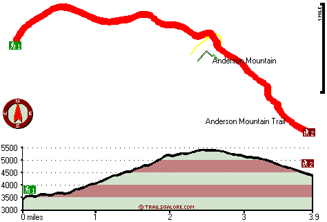
Trailhead 1 to Trailhead 2: Total hiking length = 3.9 miles Total climbing distance = 1.8 miles Difficulty : Medium Casual Hiking Pace:
3.5 hours
Fast Hiking Pace:
2 hours
Trailhead 2 to Trailhead 1: Total hiking length = 3.9 miles Total climbing distance = 1.4 miles Difficulty : Medium Casual Hiking Pace:
3.5 hours
Fast Hiking Pace:
2 hours
| | Trailhead 1 back to Trailhead 1: Total hiking length = 7.8 miles Total climbing distance = 3.2 miles Difficulty : Difficult Casual Hiking Pace:
7 hours
Fast Hiking Pace:
4.5 hours
Trailhead 2 back to Trailhead 2: Total hiking length = 7.8 miles Total climbing distance = 3.2 miles Difficulty : Difficult Casual Hiking Pace:
7 hours
Fast Hiking Pace:
4.5 hours
|
Total elevation difference: 2406 feet

La Quinta Inn and Suites White City, White City
|
38 miles away
The new La Quinta Inn & Suites White City, near Medford, the gateway to Crater Lake National Park, provides spacious, modern rooms with amenities that include microwave, refrigerator, free high-speed ...
|
| |
Best Western Oakridge Inn, Oakridge
|
39 miles away
This Oakridge, Oregon hotel offers a complimentary continental breakfast each morning and convenient access to a variety of outdoor activities. Discover the Best Western Oakridge Inn, nestled agains...
|
|
User input for Sandstone Trail, Southern Cascade Range, Douglas County, Oregon:

Outdoors Recreation Near Medford, Oregon Very comprehensive list of a variety of outdoors recreation in the vicinity of Medford, Oregon, the metro area neareast to Sandstone Trail. Find info on campgrounds, hiking trails, ski resorts, lakes, beaches, parks, whitewater and more.
|
Current weather conditions at Sandstone Trail, Southern Cascade Range, Douglas County, Oregon

Local climate location: IDLEYLD PARK 13 miles away

           
| |
Lithia Springs Resort And Gardens, Ashland
|
40 miles away
Hello, from Ashland, Oregon Imagine, at the end of a long day's travel, relaxing in a 2 person whirlpool tub filled with hot mineral water, right in your own room. Let the relaxing quality of the min...
|
Courtyard Medford Airport, Medford
|
41 miles away
Located minutes from downtown Medford and Central Point, Courtyard Medford Airport offers great accommodations and friendly service. Whether visiting for business or leisure, experience the beauty of ...
|
|
More Hotels and Campgrounds Near Sandstone Trail, Southern Cascade Range, Douglas County, Oregon
| |
| |
 |
|
| These outdoors activities are available near Sandstone Trail. |
| | Trails Near Sandstone Trail:
 |
Anderson Mountain Trail, Douglas County
County
, 2 miles away, 6.8 hiking miles, 1906 feet elevation difference |
 |
Jackson Creek Trail, Douglas County
County
, 3 miles away, 2.9 hiking miles, 1219 feet elevation difference |
 |
Umpqua Rogue Trail, Douglas County
County
, 4 miles away, 3.6 hiking miles, 1122 feet elevation difference |
 |
Flat Creek Trail, Jackson County
County
, 4 miles away, 2.5 hiking miles, 229 feet elevation difference |
 |
Fish Lake Trail, Douglas County
County
, 4 miles away, 9 hiking miles, 2685 feet elevation difference |
 |
Union Creek Trail, Jackson County
County
, 6 miles away, 7 hiking miles, 412 feet elevation difference |
 |
Log Pile Trail, Douglas County
County
, 8 miles away, 5.2 hiking miles, 1832 feet elevation difference |
|
| | Whitewater Near Sandstone Trail:
 |
Rogue River - North Fork, Jackson County
County
, 5 miles away, Class IV - 3 miles long (Natural Bridge to Woodruff Bridge) |
 |
Rogue River - North Fork, Jackson County
County
, 10 miles away, Class III - 6 miles long (River Bridge to North Fork Park) |
 |
Jackson Creek, Douglas County
County
, 10 miles away, Class IV(V) - 8 miles long (NF300 to Cover Camp) |
 |
Rogue River - North Fork, Jackson County
County
, 13 miles away, Class IV(V+) - 3.3 miles long (Mill Creek Falls to Lost Creek Lake) |
 |
Copland Creek, Douglas County
County
, 16 miles away, Class IV(V) - 5.7 miles long (Second Bridge to North Umpqua) |
|
| | Hotels Near Sandstone Trail:
 |
La Quinta Inn and Suites White City, White City
, 38 miles away |
 |
Best Western Oakridge Inn, Oakridge
, 39 miles away |
 |
Lithia Springs Resort And Gardens, Ashland
, 40 miles away |
 |
Courtyard Medford Airport, Medford
, 41 miles away |
 |
Candlewood Suites MEDFORD, Medford
, 41 miles away |
|
|
|
 |
|