Oregon hiking trails - Round Lake Trail, Central Cascade Range, Marion County

   
  You can't spend all your time indoors you need to get out once in a while, and Round Lake Trail in Marion County, Oregon is such a wonderful place. Backcountry trails are nice and plentiful in Oregon, and among these are Round Lake Trail in Marion County. Oregon has so much to offer the great outdoors lovers. Round Lake Trail is a normal length wilderness trail having an average number of uphill miles which makes this great outdoors hiking trail nice for hard core backpackers looking for adventure. Round Lake Trail is a two ended hiking trail with two
    trailheads, so backcountry hiking it one way is an option if you can arrange for a ride back. Round Lake Trail is quite long, so don't forget to pack enough supplies. Don’t forget to check for any current restrictions or closures before you go. A lengthy tour separates Hood River
from Round Lake Trail, but there's nice natural splendor waiting here for you along it. This is just one of a large number of great outdoors hiking trails in this neighborhood. A good deal of precipitation falls at Round Lake Trail; the wettest month of the year is mostly December, that's the one that rains the most, and the driest month is July. These wilderness trails here in the Central Cascade Range are a wonderful way to explore these summits. Round Lake Trail stays roughly within the same elevation zone the whole time, so you won’t have to worry about  
different climate zones along your walk. For the period of the days of summer, highs commonly are in the 70's at Round Lake Trail, and during summer nights temperatures are in the 50's. The winter comes with highs in the 40's with temperatures at Round Lake Trail dipping down into the 30's during winter nights. Each great outdoors trail in Oregon is different from the others. You should count on this backcountry walk taking about 6 hours, but of course some people walk a bit slower and some a bit faster. Here in Oregon backcountry trekking never gets boring. Round Lake Trail is 7 miles long it's an average length backpacking trail. Sometimes this hiking and backpacking trail gets really dry, so do check for current fire restrictions before you go if you plan to bring a stove or make a camp fire. This hiking trail has a total elevation difference of 1,470 feet which is about average.

Briefly about the general area:
Yeah, come up here to the Central Cascade Range for a delightful time. A short journey to Maryanne Spring is always worthwhile, and why not take a little tour to Gyp Creek since you're here. Be careful coming to the Central Cascade Range, you might not ever want to go back home again. Frazier Turnaround Campground is a great campground nearby.
Any time is a brilliant time at Round Lake Trail if you love the outdoors. Round Meadow is a charming spot any time of year, and get yourself into a kayak and hit Collawash River. A pleasant tour to Fawn Meadow is a brilliant way to spend an afternoon; some nearby water includes Round Creek. If you came for an overnight stay Lemiti Campground is a pleasant spot to camp, and a splendid place nearby is Graham Pass.
A spree to Round Lake Trail wouldn't be complete without taking a look at Fadeaway Spring; if you come at the right time of year, Clackamas River offers some delightful whitewater.

Location of Trailhead 1: Latitude 44.8733, Longitude -121.9752
- - Directions and Road Map

Location of Trailhead 2: Latitude 44.8742, Longitude -121.9443
- - Directions and Road Map


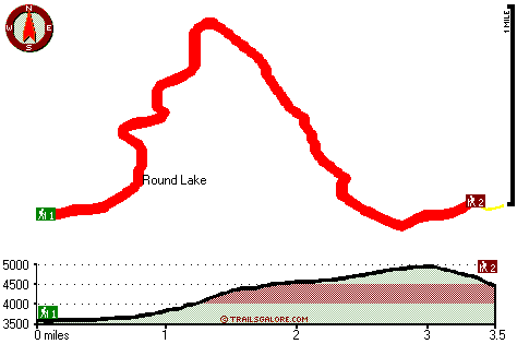
Trailhead 1 to Trailhead 2:
Total hiking length = 3.5 miles
Total climbing distance = 2.3 miles
Difficulty : Medium
Casual Hiking Pace: 3.5 hours
Fast Hiking Pace: 2 hours

Trailhead 2 to Trailhead 1:
Total hiking length = 3.5 miles
Total climbing distance = .6 miles
Difficulty : Easy
Casual Hiking Pace: 2.5 hours
Fast Hiking Pace: 1.5 hours
    Trailhead 1 back to Trailhead 1:
Total hiking length = 7 miles
Total climbing distance = 2.9 miles
Difficulty : Difficult
Casual Hiking Pace: 6 hours
Fast Hiking Pace: 4 hours

Trailhead 2 back to Trailhead 2:
Total hiking length = 7 miles
Total climbing distance = 2.9 miles
Difficulty : Difficult
Casual Hiking Pace: 6 hours
Fast Hiking Pace: 4 hours

Total elevation difference: 1470 feet


Whispering Woods (Vri), Welches
22 miles away
Whispering Woods is a resort destination east of Portland which opened in 1981 with 42 condominiums. The second phase of 24 additional condominiums opened in 1992. The resort offers a clubhouse with a...
  
Resort at the Mountain, Welches
22 miles away
The Resort at The Mountain is the premier Northwest golf and ski resort located in the Highlands of Oregon just an hour east of Portland at the western base of Mt. Hood. The Resort features 160 gues...
User input for Round Lake Trail, Central Cascade Range, Marion County, Oregon:

Submit Input:
Your Name:
Write or Paste Input here:

Upload picture:      Review Guidelines


Outdoors Recreation Near Hood River, Oregon
Very comprehensive list of a variety of outdoors recreation in the vicinity of Hood River, Oregon, the metro area neareast to Round Lake Trail. Find info on campgrounds, hiking trails, ski resorts, lakes, beaches, parks, whitewater and more.

Current weather conditions at Round Lake Trail, Central Cascade Range, Marion County, Oregon
WXPort

Local climate location: THREE LYNX 10 miles away

Mount Hood Inn, Government Camp
25 miles away
At the Mount Hood Inn we offer our guests the finest accommodations on the mountain. With our modern facilities and friendly local staff we are able to give you the attention and service you have com...

Lodge at Suttle Lake, Sisters
33 miles away
We are not your typical hotel. Nestled in the heart of the Deschutes National Forest amid soaring pines. Suttle Lake Resort provides an enchanted escape. Our resorts mountain views and pristine lake w...

More Hotels and Campgrounds Near Round Lake Trail, Central Cascade Range, Marion County, Oregon

OTHER_INFO
  Central Cascade Range Campgrounds
Complete list of all the campgrounds in the Central Cascade Range.

Central Cascade Range Outdoors Info
Complete outdoors info for the Central Cascade Range.

Oregon Hiking Trails
Complete list of all hiking trails in Oregon

Books about hiking trails in Oregon
List of books available on Amazon.com about hiking trails in Oregon.

Oregon Outdoors Index
This is a very comprehensive index of outdoors activities in the great state of Oregon.


TOPO
High quality water resistant topo map of Round Lake Trail, Central Cascade Range, Marion County, Oregon.

OUTDOORS_GUIDE
These outdoors activities are available near Round Lake Trail.
 Trails Near Round Lake Trail:
Hunter Camp Way, Marion County County , 2 miles away, 1.7 hiking miles, 638 feet elevation difference
East Fork Way, Marion County County , 3 miles away, 2.1 hiking miles, 913 feet elevation difference
Scorpion Mountain Trail, Marion County County , 3 miles away, 0.5 hiking miles, 176 feet elevation difference
Rhododendron Ridge Trail, Clackamas County County , 3 miles away, 4 hiking miles, 887 feet elevation difference
Janus Butte Trail, Marion County County , 4 miles away,  8.2 hiking miles, 2376 feet elevation difference
Lowe Creek Trail, Clackamas County County , 4 miles away, 4.6 hiking miles, 1307 feet elevation difference
Rapidan Trail, Marion County County , 4 miles away,  4.4 hiking miles, 1359 feet elevation difference
 Camp Grounds Near Round Lake Trail:
Lemiti Campground, Clackamas County, 12 miles away
Frazier Turnaround Campground, Clackamas County, 13 miles away
Frazier Fork Campground, Clackamas County, 13 miles away
Skookum Lake Campground, Clackamas County, 15 miles away
Shining Lake Campground, Clackamas County, 15 miles away
 Whitewater Near Round Lake Trail:
Collawash River, Marion County County , 5 miles away, Class III-IV(V) - 5 miles long (Elk Lake Creek to river mile 5.5)
Clackamas River, Clackamas County County , 7 miles away, Class III-IV - 8 miles long (June Creek Br. to Collawash River)
Collawash River, Marion County County , 9 miles away, Class IV - 5.5 miles long (Mile 5.5 bridge to Two Rivers Picnic Area)
Breitenbush River, Marion County County , 10 miles away, Class IV - 8.2 miles long (Cleator Bend Campground to Detroit Lake)
Clackamas River - Oak Grove Fork, Clackamas County County , 10 miles away, Class III-V(V+) - 5 miles long (Lower Five Miles to Clackamas River)
 Hotels Near Round Lake Trail:
Whispering Woods (Vri), Welches , 22 miles away
Resort at the Mountain, Welches , 22 miles away
Mount Hood Inn, Government Camp , 25 miles away
Lodge at Suttle Lake, Sisters , 33 miles away
Best Western Sandy Inn, Sandy , 34 miles away

Outdoors related information copyright © Stratus-Pikpuk, Inc. - Detailed hotel information copyright © Interactive Hotel Solutions