| |
|
| | Oregon has lots of outdoors pastimes. Glorious hiking trails in Oregon are in abundance, and Rough Creek Trail in Douglas County is one of them. We all need to get out in the fresh air once in a while, and Rough Creek Trail in Douglas County, Oregon is a magnificent spot for getting out. Now this great outdoors hiking trail is pretty long, so do pack enough food to last the whole trip. Backpacking trails like this one here in the Southern Cascade Range are the best way to enjoy these highlands. This vicinity does get very dry sometimes, so make sure you check |
|
current conditions and fire restrictions with local forest authorities before you head out. With its 10.4 miles of walking distance; it's longer than many backcountry trails. Summer at Rough Creek Trail arrives with high temperatures in the 80's with nighttime lows in the 40's.
| | The cold days of the winter come with highs in the 40's; after the sun is down through the winter temperatures at Rough Creek Trail drop into the 20's. Far from civilization you hit upon Rough Creek Trail, and backcountry hiking along this wilderness trail is very fun. This hiking trail has two trailheads which means you have the option of backcountry trekking it one way if you have someone to pick you up at the other end. You should count on this backcountry walk taking about 9 hours, but you never know stuff could go wrong and you could get stuck so be | |
|
prepared for that. This is one of many backcountry trails in the surrounding region. Rough Creek Trail is a very long backcountry hiking trail with an average amount of climbing distance which makes this backcountry trail tremendous for hard core backpackers looking for adventure.
Here in the splendid state of Oregon hiking is so much fun. Every Oregon hiking trail is different from the others. Rough Creek Trail gets a lot of water; November is the wettest month with most rain, and July is when it's the driest. Please follow all local rules about fires and
camping. This hiking trail has a total elevation difference of 2,837 feet which is higher than average. This backcountry trail goes through some very different elevations, and that means that some parts of the backcountry trail could be very different from other parts of it.
Briefly
about the general area: So many exciting things to do at Rough Creek Trail, so little time. A pleasant spree to Lonesome Meadow is a good way to spend an afternoon, and Devils Canyon is another great place to stop at close by. Whohoo, so many cool things in one place!
The Southern Cascade Range is unbeatable! If time allows, Crater Lake National Park is a national park worth taking a look at, and since you're here, you could stop at Dog Prairie Creek. A short trip to Whitehorse Falls is always worthwhile, and a quick tour to Skookum Creek is
unquestionably a great idea. A brilliant place for whitewater paddling next to Rough Creek Trail is Rogue River - North Fork; Watson Falls is always fun to check out. You just can't imagine the amount of outdoors exciting stuff the Southern Cascade Range has to offer. While
you're here at Rough Creek Trail it's a great idea to go to Skookum Prairie, and if you came to camp Camas Creek Campground is a nice place to do that. Get your pulse rate up on the tremendous whitewater of Copland Creek. There's so much to do here at Rough Creek Trail that you need to camp here for a while, Haymaker Campground is a splendid spot for that.
|
|
Location of Trailhead 1: Latitude 43.2005, Longitude -122.3787 - - Directions and Road Map
Location of Trailhead 2: Latitude 43.1481, Longitude -122.319 - - Directions and Road Map

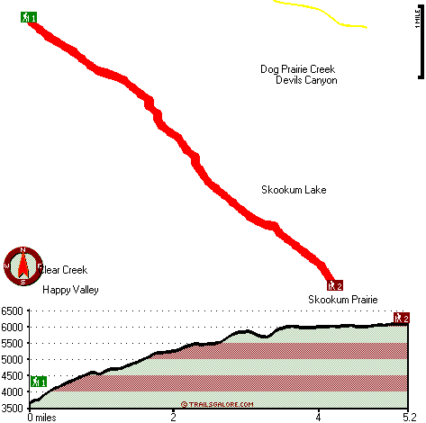
Trailhead 1 to Trailhead 2: Total hiking length = 5.2 miles Total climbing distance = 3.4 miles Difficulty : Medium Casual Hiking Pace:
5.5 hours
Fast Hiking Pace:
3 hours
Trailhead 2 to Trailhead 1: Total hiking length = 5.2 miles Total climbing distance = .8 miles Difficulty : Easy Casual Hiking Pace:
3.5 hours
Fast Hiking Pace:
2 hours
| | Trailhead 1 back to Trailhead 1: Total hiking length = 10.4 miles Total climbing distance = 4.2 miles Difficulty : Difficult Casual Hiking Pace:
9 hours
Fast Hiking Pace:
6 hours
Trailhead 2 back to Trailhead 2: Total hiking length = 10.4 miles Total climbing distance = 4.2 miles Difficulty : Difficult Casual Hiking Pace:
9 hours
Fast Hiking Pace:
6 hours
|
Total elevation difference: 2837 feet

Best Western Oakridge Inn, Oakridge
|
30 miles away
This Oakridge, Oregon hotel offers a complimentary continental breakfast each morning and convenient access to a variety of outdoor activities. Discover the Best Western Oakridge Inn, nestled agains...
|
| |
|
User input for Rough Creek Trail, Southern Cascade Range, Douglas County, Oregon:

Outdoors Recreation Near Medford, Oregon Very comprehensive list of a variety of outdoors recreation in the vicinity of Medford, Oregon, the metro area neareast to Rough Creek Trail. Find info on campgrounds, hiking trails, ski resorts, lakes, beaches, parks, whitewater and more.
More Hotels and Campgrounds Near Rough Creek Trail, Southern Cascade Range, Douglas County, Oregon
| |
| |
 |
|
| These outdoors activities are available near Rough Creek Trail. |
| | Trails Near Rough Creek Trail:
 |
Dog Prairie Trail, Douglas County
County
, 2 miles away, 6.5 hiking miles, 2782 feet elevation difference |
 |
Rim Rock Trail, Douglas County
County
, 4 miles away, 0.8 hiking miles, 586 feet elevation difference |
 |
Rattlesnake Way, Douglas County
County
, 4 miles away, 7.2 hiking miles, 2853 feet elevation difference |
 |
Three Lakes Trail, Douglas County
County
, 5 miles away, 4.4 hiking miles, 669 feet elevation difference |
 |
Buck Canyon Trail, Douglas County
County
, 5 miles away, 3.7 hiking miles, 1181 feet elevation difference |
 |
Pig Iron Trail, Douglas County
County
, 5 miles away, 7.3 hiking miles, 2153 feet elevation difference |
 |
Grave Creek Trail, Douglas County
County
, 6 miles away, 6.2 hiking miles, 3150 feet elevation difference |
|
| | Whitewater Near Rough Creek Trail:
 |
Copland Creek, Douglas County
County
, 14 miles away, Class IV(V) - 5.7 miles long (Second Bridge to North Umpqua) |
 |
Rogue River - North Fork, Jackson County
County
, 18 miles away, Class IV - 3 miles long (Natural Bridge to Woodruff Bridge) |
 |
Jackson Creek, Douglas County
County
, 21 miles away, Class IV(V) - 8 miles long (NF300 to Cover Camp) |
 |
Rogue River - North Fork, Jackson County
County
, 22 miles away, Class III - 6 miles long (River Bridge to North Fork Park) |
 |
Steamboat Creek, Douglas County
County
, 23 miles away, Class II+(IV) - 9.5 miles long (City Creek to Steamboat Falls) |
|
|
|
 |
|