Oregon hiking trails - Roosevelt Way, Central Cascade Range, Lane County

   
  Oregon has lots of outdoors things to do. Oregon has plenty of brilliant backpacking trails, and one of these is Roosevelt Way in Lane County. Each one of the many backpacking trails of Oregon has its own unique attractiveness. Roosevelt Way sees pretty high levels of precipitation; during November this vicinity sees the most rain, and the driest month of the year is July. There are not too many trails in this area. This backcountry hiking trail is not that long but it's always great to bring some emergency supplies, you never know what could happen. This
    backcountry hiking trail sometimes gets very dry, so do check for current fire restrictions before you go if you plan to bring a stove or make a camp fire. Don’t forget to check for any current restrictions or closures before you go. Different parts of Roosevelt Way are at very
different elevations which of course means you need to be prepared for different conditions on different parts of the great outdoors trail. This backcountry hiking trail is a normal length backcountry hiking trail with an average amount of climbing distance which makes this trail glorious for the average backcountry walker looking for a fun adventure. Roosevelt Way is a one trailhead hiking trail, so in and out is the way to backcountry hike it normally. Being 5.4 miles long it's an average length great outdoors trail. The beautiful backcountry hiking trails  
of the Central Cascade Range are a magnificent way to explore these hills. This hike shouldn't take more than 5 hours, but of course some folks walk a bit slower and some a bit faster. For the duration of the summer highs here at Roosevelt Way get into the 80's while nighttime lows are generally in the 50's. Highs during the winter are generally in the 40's while Roosevelt Way nighttime low temperatures during the winter are in the 30's. If you happen to be in Oregon, why not go backpacking, it is an outstanding way to spend some time. This hiking trail has a total elevation difference of 2,210 feet which is an average number. Because Roosevelt Way is very secluded from society, many folks like to trek here to be in the neighborhood of nature. Alright, enough of spending all this time inside a building, time to get out, and Roosevelt Way in Lane County, Oregon is an outstanding spot to go.

Briefly about the general area:
So much exciting stuff to do at Roosevelt Way, so little time. Major Prairie is a great location here at Roosevelt Way, and if you came to camp Oakridge RV Park is a great place to do that.
If you're here at Roosevelt Way, you could go to Roosevelt Creek. There's so much to do here at Roosevelt Way that you need to camp here for a while, Twin Springs Campground is a pleasant place for that. Devils Canyon is a good place to spend some time at, and Christy Creek is a magnificent whitewater spot close by. Having a pleasant time in the Central Cascade Range is painless. In the event that you don’t have a problem getting drenched, you can always go whitewater paddling on Willamette River - North Fork of Middle Fork, and unsurprisingly Evergreen Creek flows through this area.

Location of Trailhead: Latitude 43.8455, Longitude -122.287
- - Directions and Road Map

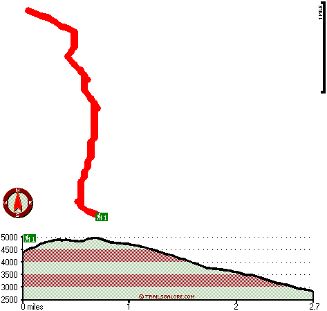
Total in and out hiking length = 5.4 miles

Total climbing distance = 2.4 miles

Difficulty : Medium

Casual Hiking Pace: 5 hours

Fast Hiking Pace: 3 hours

Total elevation difference: 2210 feet


Best Western Oakridge Inn, Oakridge
15 miles away
This Oakridge, Oregon hotel offers a complimentary continental breakfast each morning and convenient access to a variety of outdoor activities. Discover the Best Western Oakridge Inn, nestled agains...
  
Comfort Inn & Suites Creswell, Creswell
49 miles away
Welcome to the Comfort Inn and Suites of Creswell. This hotel is close to a golf course and is within walking distance of shops and restaurants. We are just a short drive to rivers, lakes and other ou...
User input for Roosevelt Way, Central Cascade Range, Lane County, Oregon:

Submit Input:
Your Name:
Write or Paste Input here:

Upload picture:      Review Guidelines


Outdoors Recreation Near Albany-Lebanon, Oregon
Very comprehensive list of a variety of outdoors recreation in the vicinity of Albany-Lebanon, Oregon, the metro area neareast to Roosevelt Way. Find info on campgrounds, hiking trails, ski resorts, lakes, beaches, parks, whitewater and more.

Current weather conditions at Roosevelt Way, Central Cascade Range, Lane County, Oregon
WXPort

Local climate location: LEABURG 12 miles away

Village Inn, Springfield
50 miles away
The Village Inn Springfield Oregon is your ideal choice for Springfield Oregon hotels. The Village Inn provides lodging near the University of Oregon, Autzen Stadium, Downtown Eugene and just blocks a...


More Hotels and Campgrounds Near Roosevelt Way, Central Cascade Range, Lane County, Oregon

OTHER_INFO
  Central Cascade Range Campgrounds
Complete list of all the campgrounds in the Central Cascade Range.

Central Cascade Range Outdoors Info
Complete outdoors info for the Central Cascade Range.

Oregon Hiking Trails
Complete list of all hiking trails in Oregon

Books about hiking trails in Oregon
List of books available on Amazon.com about hiking trails in Oregon.

Oregon Outdoors Index
This is a very comprehensive index of outdoors activities in the great state of Oregon.


TOPO
High quality water resistant topo map of Roosevelt Way, Central Cascade Range, Lane County, Oregon.

OUTDOORS_GUIDE
These outdoors activities are available near Roosevelt Way.
 Trails Near Roosevelt Way:
Dead Mountain Trail, Lane County County , 2 miles away, 5.2 hiking miles, 2108 feet elevation difference
Squaw Butte Trail, Lane County County , 6 miles away, 3.4 hiking miles, 1436 feet elevation difference
 Camp Grounds Near Roosevelt Way:
Twin Springs Campground, Lane County, 13 miles away
Oakridge RV Park, Oakridge, 13 miles away
Oakridge Mobile Home Park, Oakridge, 14 miles away
Echo Campground, Lane County, 14 miles away
Lazy Days Mobile Park, Blue River, 15 miles away
 Whitewater Near Roosevelt Way:
Christy Creek, Lane County County , 4 miles away, Class III-V(V+) - 9 miles long (to Confluence with Willamette)
Willamette River - North Fork of Middle Fork, Lane County County , 8 miles away, Class IV-V - 13.5 miles long (to Westfir)
Salt Creek, Lane County County , 8 miles away, Class III-IV - 7.2 miles long (McCredie Hot Springs to Rigdon Road Bridge)
Salmon Creek, Lane County County , 9 miles away, Class II-V - 12 miles long (Top of Upper Salmon Creek Gorge to Oakridge)
McKenzie River - South Fork, Lane County County , 10 miles away, Class III-IV - 6.2 miles long (Dutch Oven Camp to Cougar Reservoir)
 National Parks Near Roosevelt Way:
Crater Lake National Park, Crater Lake - OR , 49 miles away
 Hotels Near Roosevelt Way:
Best Western Oakridge Inn, Oakridge , 15 miles away
Comfort Inn & Suites Creswell, Creswell , 49 miles away
Village Inn, Springfield , 50 miles away

Outdoors related information copyright © Stratus-Pikpuk, Inc. - Detailed hotel information copyright © Interactive Hotel Solutions