| |
|
| | While visiting this region in Oregon it's a nice idea to go hiking too. Here in Oregon backcountry hiking is always an exciting thing to do. Pretty far from Hood River you encounter Roaring River Trail, but many people like to backcountry walk here to be close to the wilderness. You can't spend all your time indoors you need to get out once in a while, and Roaring River Trail in Clackamas County, Oregon is a really fine place to spend some time. Summertime at Roaring River Trail arrives with high temperatures in the 70's, and the overnight is fairly chillier |
|
of course, frequently in the 50's. Highs through the wintertime are frequently in the 40's with winter lows in the 30's overnight here at Roaring River Trail. Roaring River Trail is quite long, so make sure you bring plenty of supplies. This is an area covered with lots of great
| | outdoors hiking trails. Every single Oregon backcountry hiking trail has its own character. Some parts of this hiking trail are much higher up than other parts of the hiking trail which of course means you need to be prepared for different conditions on different parts of the hiking trail. Great backcountry hiking trails in Oregon are in abundance; one of them being Roaring River Trail in Clackamas County. The pretty great outdoors trails of the Central Cascade Range are a nice way to explore these highlands. This neighborhood does get very dry sometimes, | |
|
so don’t forget to check for any current fire restrictions before you go. Roaring River Trail is a great outdoors trail of nice length with an average amount of climbing distance which makes this great outdoors hiking trail perfect for hard core backpackers looking for adventure.
Don’t forget to check for any current restrictions or closures before you go. Roaring River Trail has a total elevation difference of 4,083 feet which is higher than average. With its 14.4 miles of walking distance; it's considered a longer hike. Of course, this is an overnight
backcountry trek, 2 days normally, so better have big backpack to fit all the stuff you need. Roaring River Trail is a two ended hiking and backpacking trail with two trailheads, so trekking it one way is an option if you can arrange for a ride back. Roaring River Trail is a wet
site that gets a large amount of rain; of all the months in a year December is the one with the most rain while July is mostly the driest month.
Briefly about the general area: That right there is a load of amusing stuff already but it goes on, the Central Cascade Range
has it all. Shining Creek is close to Roaring River Trail and is always a diversion to explore; Roaring River Trail is glorious enough to spend more than a day at, Lookout Springs Campground is a glorious local campground. This river is so great. While you're here at Roaring
River Trail it's a good idea to have a look at Rock Lakes Basin, and in case you don’t have a problem getting drenched, you can always go whitewater paddling on Roaring River. Near Roaring River Trail you hit upon The Narrows which is a brilliant site to check out, and Clackamas
River - Oak Grove Fork is a wonderful whitewater spot close by. Be careful coming to the Central Cascade Range, you might not ever want to return back home again. Some nearby water includes South Fork Roaring River. There's so much to do here at Roaring River Trail that you need
to camp here for a while, Shining Lake Campground is a perfect site for that. Roaring River Trail in fact is in the middle of a stunning outdoors paradise. Steep Spring is a charming site to go to while you're at Roaring River Trail, and do set aside some time for Cache Meadow if you're here at Roaring River Trail.
|
|
Location of Trailhead 1: Latitude 45.1821, Longitude -122.072 - - Directions and Road Map
Location of Trailhead 2: Latitude 45.1378, Longitude -121.9831 - - Directions and Road Map

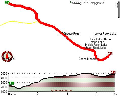
Trailhead 1 to Trailhead 2: Total hiking length = 7.2 miles Total climbing distance = 4.5 miles Difficulty : Difficult Casual Hiking Pace:
7.5 hours
Fast Hiking Pace:
4 hours
Trailhead 2 to Trailhead 1: Total hiking length = 7.2 miles Total climbing distance = 1.5 miles Difficulty : Difficult Casual Hiking Pace:
5.5 hours
Fast Hiking Pace:
3 hours
| | Trailhead 1 back to Trailhead 1: Total hiking length = 14.4 miles Total climbing distance = 6 miles Difficulty : Difficult Casual Hiking Pace:
2 days
Fast Hiking Pace:
8 hours
Trailhead 2 back to Trailhead 2: Total hiking length = 14.4 miles Total climbing distance = 6 miles Difficulty : Difficult Casual Hiking Pace:
2 days
Fast Hiking Pace:
8 hours
|
Total elevation difference: 4083 feet

|
| |
Resort at the Mountain, Welches
|
10 miles away
The Resort at The Mountain is the premier Northwest golf and ski resort located in the Highlands of Oregon just an hour east of Portland at the western base of Mt. Hood. The Resort features 160 guest ...
|
|
User input for Roaring River Trail, Central Cascade Range, Clackamas County, Oregon:

Outdoors Recreation Near Hood River, Oregon Very comprehensive list of a variety of outdoors recreation in the vicinity of Hood River, Oregon, the metro area neareast to Roaring River Trail. Find info on campgrounds, hiking trails, ski resorts, lakes, beaches, parks, whitewater and more.
More Hotels and Campgrounds Near Roaring River Trail, Central Cascade Range, Clackamas County, Oregon
| |
| |
 |
|
| These outdoors activities are available near Roaring River Trail. |
| | Trails Near Roaring River Trail:
 |
Dry Ridge Trail, Clackamas County
County
, 4 miles away, 8.6 hiking miles, 3204 feet elevation difference |
 |
Old Baldy Trail, Clackamas County
County
, 5 miles away, 11 hiking miles, 638 feet elevation difference |
 |
Fanton Plaza Trail, Clackamas County
County
, 6 miles away, 4.8 hiking miles, 1787 feet elevation difference |
 |
Cottonwood Meadows Trail, Clackamas County
County
, 6 miles away, 2.5 hiking miles, 1564 feet elevation difference |
 |
Eagle Creek Cutoff, Clackamas County
County
, 6 miles away, 7.3 hiking miles, 2830 feet elevation difference |
 |
Coffman Camp Trail, Clackamas County
County
, 7 miles away, 8.6 hiking miles, 2759 feet elevation difference |
 |
Bagby Trail, Clackamas County
County
, 8 miles away, 2.7 hiking miles, 602 feet elevation difference |
|
| | Whitewater Near Roaring River Trail:
 |
Clackamas River - Oak Grove Fork, Clackamas County
County
, 4 miles away, Class III-V(V+) - 5 miles long (Lower Five Miles to Clackamas River) |
 |
Roaring River, Clackamas County
County
, 4 miles away, Class III-IV - 3 miles long (Road 4611 to Roaring River Campground) |
 |
Clackamas River, Clackamas County
County
, 5 miles away, Class -blank- - 9.2 miles long (Collawash River to Three Lynx Power Station) |
 |
Clackamas River, Clackamas County
County
, 7 miles away, Class III-IV - 8 miles long (June Creek Br. to Collawash River) |
 |
Collawash River, Marion County
County
, 8 miles away, Class IV - 5.5 miles long (Mile 5.5 bridge to Two Rivers Picnic Area) |
|
| | Hotels Near Roaring River Trail:
 |
The Resort At The Mountain, Welches
, 10 miles away |
 |
Old Welches Inn, Welches
, 10 miles away |
 |
Resort at the Mountain, Welches
, 10 miles away |
 |
Whispering Woods (Vri), Welches
, 10 miles away |
 |
Whispering Woods Resort, Welches
, 10 miles away |
|
|
|
 |
|