| |
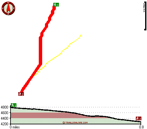
This great outdoors trail has a total elevation difference of 586 feet, and that is lower than average. This area does get very dry sometimes, so do check for current fire restrictions before you go if you plan to bring a stove or make a camp fire. The great outdoors hiking trail stays roughly within the same elevation zone the whole time which means the conditions are about the same from start to finish. The time needed for this backcountry walk is roughly 1.5 hours, but you never know stuff could go wrong and you could get stuck so be prepared for that. This is not a very long wilderness trail but you should still bring some emergency supplies just in case something happens. There are two trailheads to chose from, one in each end, so backpacking it one way is an option if you can arrange for a ride back. With its 1.6 miles of walking distance it's a short great outdoors hiking trail.
|
Trailhead 1 to Trailhead 2:
Total hiking length = .8 miles
Total climbing distance = 0 miles
Difficulty : Easy
Casual Hiking Pace:
.5 hours
Fast Hiking Pace:
.25 hours
Trailhead 2 to Trailhead 1:
Total hiking length = .8 miles
Total climbing distance = .7 miles
Difficulty : Medium
Casual Hiking Pace:
1 hours
Fast Hiking Pace:
.5 hours
| | Trailhead 1 back to Trailhead 1:
Total hiking length = 1.6 miles
Total climbing distance = .7 miles
Difficulty : Medium
Casual Hiking Pace:
1.5 hours
Fast Hiking Pace:
1 hours
Trailhead 2 back to Trailhead 2:
Total hiking length = 1.6 miles
Total climbing distance = .7 miles
Difficulty : Medium
Casual Hiking Pace:
1.5 hours
Fast Hiking Pace:
1 hours
|
Total elevation difference: 586 feet
|


