Oregon hiking trails - Red Lake Trail, Southern Cascade Range, Klamath County

   
  Backpacking in Oregon is the fine thing to do. This part of Oregon has a glorious deal of available outdoors activities. Trails for backpacking, and backpacking can be found all over Oregon, and Red Lake Trail in Klamath County is one of them. There are plenty of great outdoors hiking trails in Oregon; each one of them is different from the others. This neighborhood does get very dry sometimes, so make sure you check current conditions and fire restrictions with local forest authorities before you head out. Now, this is roughly a 3-day backcountry hike,
    so it's a wonderful thing if your backpack is big enough to do the job. Put on your backcountry backpacking shoes, and hit the hiking trail, Red Lake Trail in Klamath County, Oregon is a really splendid location to spend some time. The total elevation difference for this trail
is 1,759 feet, and that is about average. This is a backcountry hiking trail that is quite long, so don't forget to pack enough supplies. Don’t forget to check for any current restrictions or closures before you go. Being 20.6 miles long; it's a long wilderness trail. The yearly rainfall here at Red Lake Trail is about average; all through the month of November you get the most rain around here while July is regularly the driest month. Red Lake Trail is a very long great outdoors hiking trail with an average amount of climbing distance which makes this  
backcountry hiking trail good for hard core backpackers looking for adventure. Through the warm days of summer at Red Lake Trail temperatures are commonly in the 80's. Summer night lows fall down to the 40's. The winter brings highs down to the 40's with temperatures at Red Lake Trail dipping down into the 20's during winter nights. This is just one of a large number of backcountry hiking trails in this region. You'll have to go far from Klamath Falls to get to Red Lake Trail, but it is a really splendid hiking trail. Different parts of Red Lake Trail are at very different elevations which of course means you need to be prepared for different conditions on different parts of the wilderness trail. Trails like this one here in the Southern Cascade Range are a glorious way to explore these mountains. This trail has two trailheads, so if you can get a ride from someone, you can backcountry trek it just one way.

Briefly about the general area:
Some of the water close by flows, like Swan Creek, and don't leave Red Lake Trail without first paying a visit to Onion Spring. You assume that's sufficient? Just getting warmed up. A spree to Wickiup Meadow revitalizes the spirit, and a visit to Crater Lake National Park is recommended.
Whohoo, so many amusing things in one place! The Southern Cascade Range is so good! If you come at the right time of year, Rogue River - North Fork offers some glorious whitewater. This is such a fun river. A tremendous spot to camp here at Red Lake Trail is Hemlock Lake Campground; the beauty of mother nature reveals herself at Christis Spring. Now, you may think that's a load but there's even more enjoyable things to do here in the Southern Cascade Range. Camping is available at Saddle Campground, and getting to Long Creek from Red Lake Trail is uncomplicated.
Everybody loves McKee Basin; nearby you discover Doe Point.

Location of Trailhead 1: Latitude 42.606, Longitude -122.2944
- - Directions and Road Map

Location of Trailhead 2: Latitude 42.5128, Longitude -122.1894
- - Directions and Road Map


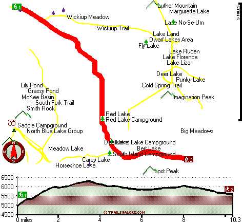
Trailhead 1 to Trailhead 2:
Total hiking length = 10.3 miles
Total climbing distance = 4.5 miles
Difficulty : Difficult
Casual Hiking Pace: 9 hours
Fast Hiking Pace: 5 hours

Trailhead 2 to Trailhead 1:
Total hiking length = 10.3 miles
Total climbing distance = 4.5 miles
Difficulty : Difficult
Casual Hiking Pace: 9 hours
Fast Hiking Pace: 5 hours
    Trailhead 1 back to Trailhead 1:
Total hiking length = 20.6 miles
Total climbing distance = 9 miles
Difficulty : Difficult
Casual Hiking Pace: 3 days
Fast Hiking Pace: 2 days

Trailhead 2 back to Trailhead 2:
Total hiking length = 20.6 miles
Total climbing distance = 9 miles
Difficulty : Difficult
Casual Hiking Pace: 3 days
Fast Hiking Pace: 2 days

Total elevation difference: 1759 feet


Running Y Ranch, Klamath Falls
29 miles away
  
Lithia Springs Resort And Gardens, Ashland
29 miles away
Hello, from Ashland, Oregon! Imagine, at the end of a long day's travel, relaxing in a 2 person whirlpool filled with hot mineral water, right in your own room. Lay back, Let the relaxing quality of t...
User input for Red Lake Trail, Southern Cascade Range, Klamath County, Oregon:

Submit Input:
Your Name:
Write or Paste Input here:

Upload picture:      Review Guidelines


Outdoors Recreation Near Klamath Falls, Oregon
Very comprehensive list of a variety of outdoors recreation in the vicinity of Klamath Falls, Oregon, the metro area neareast to Red Lake Trail. Find info on campgrounds, hiking trails, ski resorts, lakes, beaches, parks, whitewater and more.

Current weather conditions at Red Lake Trail, Southern Cascade Range, Klamath County, Oregon
WXPort

Local climate location: PROSPECT 7 miles away

Klamath Falls Super 8 Motel, Klamath Falls
34 miles away
AAA approved. Conveniently located on Hwy 97, near Hwy 140, and Hwy 66. Downtown just minutes away. Klamath Medical Center Oregon Institute of Technology, State and National Forestry offices nearby. L...

Windmill Inn And Suites Of Ashland, Ashland
35 miles away
Discover one of the Northwests most luxurious inns. Escape civilizations cares without leaving its pleasures behind. Come and enjoy the quiet side of Ashland. All suite hotel with magnificent panora...

More Hotels and Campgrounds Near Red Lake Trail, Southern Cascade Range, Klamath County, Oregon

OTHER_INFO
  Southern Cascade Range Campgrounds
Complete list of all the campgrounds in the Southern Cascade Range.

Southern Cascade Range Outdoors Info
Complete outdoors info for the Southern Cascade Range.

Oregon Hiking Trails
Complete list of all hiking trails in Oregon

Books about hiking trails in Oregon
List of books available on Amazon.com about hiking trails in Oregon.

Oregon Outdoors Index
This is a very comprehensive index of outdoors activities in the great state of Oregon.


TOPO
High quality water resistant topo map of Red Lake Trail, Southern Cascade Range, Klamath County, Oregon.

OUTDOORS_GUIDE
These outdoors activities are available near Red Lake Trail.
 Trails Near Red Lake Trail:
Wickiup Trail, Klamath County County , 2 miles away,  12.4 hiking miles, 2089 feet elevation difference
Blue Canyon Trail, Klamath County County , 2 miles away,  10 hiking miles, 763 feet elevation difference
South Fork Trail, Klamath County County , 3 miles away, 7.4 hiking miles, 1813 feet elevation difference
Blue Rock Trail, Klamath County County , 4 miles away, 7.6 hiking miles, 925 feet elevation difference
Cold Spring Trail, Klamath County County , 4 miles away, 6.5 hiking miles, 937 feet elevation difference
Four Mile Lake Trail, Klamath County County , 4 miles away,  7.4 hiking miles, 434 feet elevation difference
Hemlock Lake Trail, Klamath County County , 4 miles away,  10.4 hiking miles, 2410 feet elevation difference
 Camp Grounds Near Red Lake Trail:
Hemlock Lake Campground, Klamath County, 3 miles away
Saddle Campground, Jackson County, 4 miles away
Upper South Fork Campground, Jackson County, 5 miles away
White Pine Campground, Klamath County, 9 miles away
Sevenmile Marsh Campground, Klamath County, 10 miles away
 Whitewater Near Red Lake Trail:
Rogue River - North Fork, Jackson County County , 21 miles away, Class III - 6 miles long (River Bridge to North Fork Park)
Rogue River - North Fork, Jackson County County , 21 miles away, Class IV(V+) - 3.3 miles long (Mill Creek Falls to Lost Creek Lake)
Rogue River - North Fork, Jackson County County , 23 miles away, Class IV - 3 miles long (Natural Bridge to Woodruff Bridge)
Big Butte Creek, Jackson County County , 26 miles away, Class III-IV - 9.5 miles long (Butte Falls to Netherlands Road)
Klamath River, Klamath County County , 26 miles away, Class IV+ - 5 miles long (JC Boyle Dam to Powerhouse)
 National Parks Near Red Lake Trail:
Crater Lake National Park, Crater Lake - OR , 19 miles away
Lava Beds National Monument, Tulelake - CA , 62 miles away
 Hotels Near Red Lake Trail:
Rocky Point Station Lodging, Klamath Falls , 11 miles away
Aspen Inn Motel, Fort Klamath , 19 miles away
Ft. Klamath Lodge & Rv, Fort Klamath , 19 miles away
Wilson's Cottages, Fort Klamath , 19 miles away
Mazama Village Motor Inn, Crater Lake , 19 miles away
 Lakes Near Red Lake Trail
Red Lake, Klamath County , 1 miles away
Fly Lake, Klamath County , 2 miles away

Outdoors related information copyright © Stratus-Pikpuk, Inc. - Detailed hotel information copyright © Interactive Hotel Solutions