| |
This is a two-ended backcountry trail with two trailheads, so if you can get a ride from someone, you can walk it just one way. This backcountry trail has a total elevation difference of 1,909 feet, and that is about average. Now this hiking trail is pretty long, so don't forget to pack enough supplies. At parts of the year this neighborhood sees very little rain, so don’t forget to check for any current fire restrictions before you go. Red Butte Trail is 17.2 miles long; it's longer than many wilderness trails. Different parts of this wilderness trail are at very different elevations, and that means that some parts of the wilderness trail could be very different from other parts of it. This hike should take you about 2.5 days, so it's an excellent thing if your backpack is big enough to do the job.
|
Trailhead 1 to Trailhead 2:
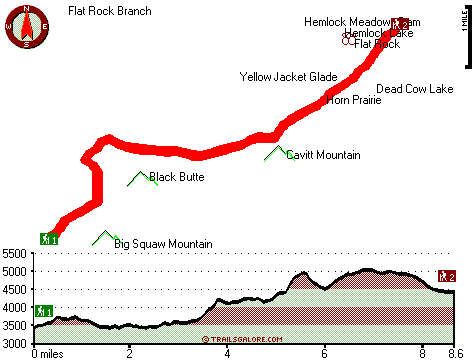
Total hiking length = 8.6 miles
Total climbing distance = 4 miles
Difficulty : Difficult
Casual Hiking Pace:
8 hours
Fast Hiking Pace:
4.5 hours
Trailhead 2 to Trailhead 1:
Total hiking length = 8.6 miles
Total climbing distance = 3.5 miles
Difficulty : Difficult
Casual Hiking Pace:
7.5 hours
Fast Hiking Pace:
4 hours
| | Trailhead 1 back to Trailhead 1:
Total hiking length = 17.2 miles
Total climbing distance = 7.5 miles
Difficulty : Difficult
Casual Hiking Pace:
2.5 days
Fast Hiking Pace:
1.5 days
Trailhead 2 back to Trailhead 2:
Total hiking length = 17.2 miles
Total climbing distance = 7.5 miles
Difficulty : Difficult
Casual Hiking Pace:
2.5 days
Fast Hiking Pace:
1.5 days
|
Total elevation difference: 1909 feet
|


