Oregon hiking trails - Rebel Rock Trail, Central Cascade Range, Lane County

   
  Because Rebel Rock Trail is very isolated from civilization, it is a good sanctuary from the town. Outdoors people generally like this part of Oregon. There are numerous backcountry hiking trails in Oregon, and each one has its own character. The length of Rebel Rock Trail is on the longer side having an average number of uphill miles which makes this hiking trail tremendous for hard core backpackers looking for adventure. Don’t forget to check for any current restrictions or closures before you go. This trail has a total elevation difference of 3,608
    feet which is a higher than average number. Put on your trekking shoes, and hit the wilderness hiking trail, Rebel Rock Trail in Lane County, Oregon is a really perfect location to spend some time. Oregon has plenty of great backcountry hiking trails; one of them being Rebel Rock
Trail in Lane County. This is a one trailhead trail, so you'll be backcountry backpacking it in and back out. Of course, this is an overnight backcountry hike, 1.5 days normally, so make sure you've got all your overnight gear packed. This hiking trail goes through some very different elevations which of course means you need to be prepared for different conditions on different parts of the hiking trail. These wilderness trails here in the Central Cascade Range are the best way to enjoy these mountains. Rebel Rock Trail is a wet spot that gets much rainfall;  
the month of December is the wettest with most of the rain, and July on the other hand is the driest. This region does get very dry sometimes, so do check for current fire restrictions before you go if you plan to bring a stove or make a camp fire. This is just one of a large number of hiking trails in this neighborhood. At Rebel Rock Trail during the warmest time of the year highs are in the 80's; the nighttime is a bit cooler of course, mostly in the 40's. Highs throughout the winter are mostly in the 40's with temperatures at Rebel Rock Trail dipping down into the 20's throughout winter nights. Now this wilderness hiking trail is pretty long, so make sure you bring plenty of supplies. Being 10.6 miles long; it's considered a longer trek. Here in the great state of Oregon backcountry backpacking is a brilliant idea.

Briefly about the general area:
Rebel Rock Trail is good enough to spend more than a day at, Echo Campground is a good local campground. Station Creek is close to Rebel Rock Trail and is always a delight to have a look at. There's so much to do here at Rebel Rock Trail that you need to camp here for a while, Twin Springs Campground is a brilliant location for that.
It's always perfect to take a look at Beeler Spring, and if you don't mind getting drenched, you can always go whitewater paddling on Horse Creek. But wait, there's more cool things to do in the Central Cascade Range. Take a little tour to Rebel Creek while you're here at Rebel Rock Trail, and McKenzie River - South Fork is a great whitewater spot nearby.

Location of Trailhead: Latitude 44.0083, Longitude -122.1712
- - Directions and Road Map

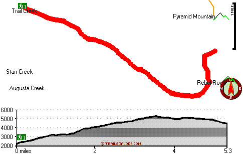
Total in and out hiking length = 10.6 miles

Total climbing distance = 4.8 miles

Difficulty : Difficult

Casual Hiking Pace: 1.5 days

Fast Hiking Pace: 6.5 hours

Total elevation difference: 3608 feet


Best Western Oakridge Inn, Oakridge
27 miles away
This Oakridge, Oregon hotel offers a complimentary continental breakfast each morning and convenient access to a variety of outdoor activities. Discover the Best Western Oakridge Inn, nestled agains...
  
Best Western Ponderosa Lodge, Sisters
43 miles away
Offers a refreshing environment with renovated rooms, new deluxe suites and smoke-free accommodations. The perfect choice while traveling the 'Gateway to the Cascades', ideally located on 14 acres sur...
User input for Rebel Rock Trail, Central Cascade Range, Lane County, Oregon:

Submit Input:
Your Name:
Write or Paste Input here:

Upload picture:      Review Guidelines


Outdoors Recreation Near Bend, Oregon
Very comprehensive list of a variety of outdoors recreation in the vicinity of Bend, Oregon, the metro area neareast to Rebel Rock Trail. Find info on campgrounds, hiking trails, ski resorts, lakes, beaches, parks, whitewater and more.

Current weather conditions at Rebel Rock Trail, Central Cascade Range, Lane County, Oregon
WXPort

Local climate location: MC KENZIE BRIDGE R S 7 miles away

Five Pine Lodge, Sisters
44 miles away
Lodging in Sisters, Oregon, at FivePine Lodge and Spa is a vacation back in time to Central Oregon's golden era of travel with every modern luxury. Whether you're practicing Tai-Chi atop Eagle Rock, p...

Best Western Newberry Station, La Pine
47 miles away
Stay at this La Pine, Oregon hotel, a central location to 5 of the major recreational areas in Oregon including Crater Lake and the 14 lake Cascade Lakes. Welcome to the Best Western Newberry Statio...

More Hotels and Campgrounds Near Rebel Rock Trail, Central Cascade Range, Lane County, Oregon

OTHER_INFO
  Central Cascade Range Campgrounds
Complete list of all the campgrounds in the Central Cascade Range.

Central Cascade Range Outdoors Info
Complete outdoors info for the Central Cascade Range.

Oregon Hiking Trails
Complete list of all hiking trails in Oregon

Books about hiking trails in Oregon
List of books available on Amazon.com about hiking trails in Oregon.

Oregon Outdoors Index
This is a very comprehensive index of outdoors activities in the great state of Oregon.


TOPO
High quality water resistant topo map of Rebel Rock Trail, Central Cascade Range, Lane County, Oregon.

OUTDOORS_GUIDE
These outdoors activities are available near Rebel Rock Trail.
 Trails Near Rebel Rock Trail:
Pyramid Trail, Lane County County , 1 miles away,  8.8 hiking miles, 3174 feet elevation difference
Tipsoo Trail, Lane County County , 4 miles away, 8.6 hiking miles, 2848 feet elevation difference
Grasshopper Trail, Lane County County , 5 miles away, 10.2 hiking miles, 2109 feet elevation difference
Hiyu Trail, Lane County County , 5 miles away,  6.8 hiking miles, 1264 feet elevation difference
Tuckta Trail, Lane County County , 5 miles away, 1 hiking miles, 894 feet elevation difference
Saddle Trail, Lane County County , 6 miles away,  2.4 hiking miles, 1641 feet elevation difference
Olallie Trail, Lane County County , 7 miles away,  10.4 hiking miles, 735 feet elevation difference
 Camp Grounds Near Rebel Rock Trail:
Twin Springs Campground, Lane County, 2 miles away
Echo Campground, Lane County, 10 miles away
Patio RV Park, Blue River, 10 miles away
Mc Kenzie River Trailer/rv Court, Blue River, 14 miles away
Lazy Days Mobile Park, Blue River, 14 miles away
 Whitewater Near Rebel Rock Trail:
McKenzie River - South Fork, Lane County County , 4 miles away, Class III-IV - 6.2 miles long (Dutch Oven Camp to Cougar Reservoir)
Horse Creek, Lane County County , 8 miles away, Class III - 11 miles long (above Separation Creek to McKenzie River)
Lookout Creek, -blank- County County , 13 miles away, Class III-IV - 2.5 miles long (2.5 miles above Blue River to Blue River)
Blue River, Linn/ Lane County County , 13 miles away, Class IV-V - 4 miles long (Quentin Creek to Blue River Reservoir)
Christy Creek, Lane County County , 14 miles away, Class III-V(V+) - 9 miles long (to Confluence with Willamette)
 National Parks Near Rebel Rock Trail:
Crater Lake National Park, Crater Lake - OR , 54 miles away
 Hotels Near Rebel Rock Trail:
Best Western Oakridge Inn, Oakridge , 27 miles away
Best Western Ponderosa Lodge, Sisters , 43 miles away
Five Pine Lodge, Sisters , 44 miles away
Best Western Newberry Station, La Pine , 47 miles away
Sunriver Resort, Sunriver , 49 miles away
 Lakes Near Rebel Rock Trail
Ruth Lake, Lane County , 4 miles away
Karl Lake, Lane County , 4 miles away

Outdoors related information copyright © Stratus-Pikpuk, Inc. - Detailed hotel information copyright © Interactive Hotel Solutions