| |
|
| | Here in Oregon backcountry backpacking is a nice idea. Rattlesnake Trail being so secluded from the least distant urban center, backcountry backpacking it is always fun. Every Oregon hiking trail is different from the others. Backcountry hiking trails are nice and plentiful in Oregon, and Rattlesnake Trail is one of them, and it's in Harney County. Not much rain falls here at Rattlesnake Trail; December is when you get the most snow here, and July meanwhile is the driest month. Rattlesnake Trail has two trailheads, so hiking it one way is an option if |
|
you can arrange for a ride back. Being 7.6 miles long it's a mid length backcountry walk. Outdoors people generally like this part of Oregon. Rattlesnake Trail has a total elevation difference of 1,144 feet which is about average. The time needed for this walk is roughly 6.5 hours,
| | but you never know stuff could go wrong and you could get stuck so be prepared for that. There's not much difference in elevation along Rattlesnake Trail, so you get pretty much the same conditions along the whole hiking trail. At parts of the year this neighborhood sees very little rain, so don’t forget to check for any current fire restrictions before you go. This is a long backpacking trail, so do pack enough food to last the whole trip. Throughout the months of summer at Rattlesnake Trail temperatures are frequently in the 80's, and the night is fairly | |
|
colder of course, regularly in the 30's. All through the wintertime highs are regularly in the 30's, and night lows in the 0's for Rattlesnake Trail. The number of backpacking trails in this area is not very high. This backpacking and hiking trail is a mid length backpacking and
hiking trail with an average amount of climbing distance which makes this a very tough backpacking trail for advanced hikers looking for an outstanding challenge. Please follow all local rules about fires and camping. Finally, backcountry backpacking time is here again, and Rattlesnake
Trail in Harney County, Oregon is a tremendous site for getting out.
Briefly about the general area: Harney Road Spring is always fun to check out; why not camp at Sands Overnight Trailer Park if you're here at Rattlesnake Trail. Juniper Flat Spring is a good local attraction,
and do set aside some time for Perry Meadows while you're here at Rattlesnake Trail. There's some flowing water nearby, Middle Fork Rattlesnake Creek is a stream you can check out while you're here; don’t forget to take a look at Call Meadow while you're here at Rattlesnake
Trail. What a place this is for outdoors folks. East Fork Rattlesnake Creek is near Rattlesnake Trail and is always a bliss to stop at, and camping is available at Crystal Crane Hot Springs.
|
|
Location of Trailhead 1: Latitude 43.7497, Longitude -118.7991 - - Directions and Road Map
Location of Trailhead 2: Latitude 43.796, Longitude -118.8327 - - Directions and Road Map

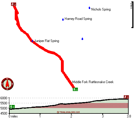
Trailhead 1 to Trailhead 2: Total hiking length = 3.8 miles Total climbing distance = 2.7 miles Difficulty : Difficult Casual Hiking Pace:
4 hours
Fast Hiking Pace:
2.5 hours
Trailhead 2 to Trailhead 1: Total hiking length = 3.8 miles Total climbing distance = .2 miles Difficulty : Easy Casual Hiking Pace:
2.5 hours
Fast Hiking Pace:
1.5 hours
| | Trailhead 1 back to Trailhead 1: Total hiking length = 7.6 miles Total climbing distance = 2.9 miles Difficulty : Difficult Casual Hiking Pace:
6.5 hours
Fast Hiking Pace:
4 hours
Trailhead 2 back to Trailhead 2: Total hiking length = 7.6 miles Total climbing distance = 2.9 miles Difficulty : Difficult Casual Hiking Pace:
6.5 hours
Fast Hiking Pace:
4 hours
|
Total elevation difference: 1144 feet

Burns - Days Inn Ponderosa, Burns
|
19 miles away
Days Inn - Burns is located in Downtown Burns only 3/4 of a mile from Old Camp Casino. We are within walking distance to shopping, a theater and laundry facilities are less than 100 yards away. Days...
|
| |
Americas Best Inns-Burns, Burns
|
20 miles away
America's Best Inn and Suites have become known for comfort, value and the friendly attention of a welcoming staff that cares. At America's Best Inns and Suites, we keep your comfort in mind and offer...
|
|
User input for Rattlesnake Trail, Harney County, Oregon:

Outdoors Recreation Near Pendleton-Hermiston, Oregon Very comprehensive list of a variety of outdoors recreation in the vicinity of Pendleton-Hermiston, Oregon, the metro area neareast to Rattlesnake Trail. Find info on campgrounds, hiking trails, ski resorts, lakes, beaches, parks, whitewater and more.
More Hotels and Campgrounds Near Rattlesnake Trail, Harney County, Oregon
| |
|
| These outdoors activities are available near Rattlesnake Trail. |
| | Hotels Near Rattlesnake Trail:
 |
Burns - Days Inn Ponderosa, Burns
, 19 miles away |
 |
Americas Best Inns-Burns, Burns
, 20 miles away |
 |
Best Western Rory & Ryan Inns, Hines
, 21 miles away |
 |
Best Western John Day Inn, John Day
, 34 miles away |
|
|
|
 |
|