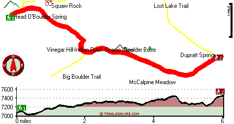
| |
|
| | Tremendous great outdoors trails in Oregon are in abundance; Princess Trail is one of them, and it's in Grant County. Here in Oregon backcountry hiking never gets boring. We all need to get out in the fresh air once in a while, and if you happen to be in Grant County of Oregon, Princess Trail is a glorious local backcountry hiking trail for doing a bit of leg stretching. Princess Trail is very far from the closest large urban center, and you always have a glorious time when you're backcountry backpacking along it. This hiking trail is many miles long |
|
having an average number of uphill miles which makes this great outdoors hiking trail great for hard core backpackers looking for adventure. Summer brings highs in the 80's to Princess Trail. When the night sets in temperatures drop down into the 30's. For the duration of the wintertime
| | this place gets highs in the 30's while the cold winter nights at Princess Trail are in the 10's. Princess Trail is usually a rather dried out location; the wettest month of the year is usually November, that's the one that rains the most; July is the month with the least moisture. This part of Oregon has a wonderful deal of available outdoors pastimes. Every Oregon great outdoors trail is worth backcountry hiking. There's not much difference in elevation along the wilderness trail which means the conditions are about the same from start to finish. Sometimes | |
|
this backpacking trail gets really dry, so don’t forget to check for any current fire restrictions before you go. With its 12 miles of walking distance; it's longer than many wilderness trails. This is just one of a large number of great outdoors hiking trails in this neighborhood.
This trek should take you about 2 days, so make sure you've got all your overnight gear packed. Princess Trail is quite long, so don't forget to pack enough supplies. The total elevation difference for Princess Trail is 477 feet, and that is lower than average. These hiking trails
here in the Blue Mountains are the best way to enjoy these hills. Don’t forget to check for any current restrictions or closures before you go. Princess Trail is a two ended backpacking and hiking trail with two trailheads, so if you can get a ride from someone, you can backcountry
walk it just one way.
Briefly about the general area: Some nearby water includes East Fork of North Fork Desolation Creek, and Head O'Boulder Spring is a stunning place to stop by while you're at Princess Trail. Stay the night at Deerhorn Campground, and spots like McCalpine
Meadow are glorious to take a look at. These mountains rock, just explore all the exciting things to do in the Blue Mountains. Corey Gulch is a great place to explore; Plute Spring is always fun to check out. Yep, outdoors enjoyable stuff to do are beyond doubt plentiful here
at Princess Trail. If you don't mind getting covered with water, you can always go whitewater paddling on John Day River - North Fork. You'll need more than a day to discover everything Princess Trail has to offer, you can camp at Corrigal Spring Campground. Getting to West Fork
of North Fork Desolation Creek from Princess Trail is simple; Desolation Meadows is a nice spot. You completely have to fancy the Blue Mountains.
|
|
Location of Trailhead 1: Latitude 44.7512, Longitude -118.692 - - Directions and Road Map
Location of Trailhead 2: Latitude 44.7345, Longitude -118.6053 - - Directions and Road Map

Trailhead 1 to Trailhead 2: Total hiking length = 6 miles Total climbing distance = 3.3 miles Difficulty : Difficult Casual Hiking Pace:
6 hours
Fast Hiking Pace:
3 hours
Trailhead 2 to Trailhead 1: Total hiking length = 6 miles Total climbing distance = 2.1 miles Difficulty : Difficult Casual Hiking Pace:
5 hours
Fast Hiking Pace:
2.5 hours
| | Trailhead 1 back to Trailhead 1: Total hiking length = 12 miles Total climbing distance = 5.4 miles Difficulty : Difficult Casual Hiking Pace:
2 days
Fast Hiking Pace:
7 hours
Trailhead 2 back to Trailhead 2: Total hiking length = 12 miles Total climbing distance = 5.4 miles Difficulty : Difficult Casual Hiking Pace:
2 days
Fast Hiking Pace:
7 hours
|
Total elevation difference: 477 feet

Best Western John Day Inn, John Day
|
26 miles away
This charming John Day, Oregon hotel is minutes from a variety of outdoor activities and walking distance from many local shops and restaurants. Located in Eastern Oregon's beautiful John Day Valley...
|
| |
|
User input for Princess Trail, Blue Mountains, Grant County, Oregon:

Outdoors Recreation Near Pendleton-Hermiston, Oregon Very comprehensive list of a variety of outdoors recreation in the vicinity of Pendleton-Hermiston, Oregon, the metro area neareast to Princess Trail. Find info on campgrounds, hiking trails, ski resorts, lakes, beaches, parks, whitewater and more.
|
Current weather conditions at Princess Trail, Blue Mountains, Grant County, Oregon

Local climate location: UKIAH 17 miles away

           
| |
Pendleton Super 8 Motel, Pendleton
|
46 miles away
*Complimentary SuperStart Breakfast, indoor heated pool and whirlpool, free Wireless High Speed Internet, Direct TV - w/5 HBO, suites w/jacuzzi, micro-fridge, pets allowed w/permission ($10 non refund...
|
Best Western Pendleton Inn, Pendleton
|
46 miles away
This Pendleton, Oregon hotel provides an expanded continental breakfast and is located two miles from the Pendleton Rodeo Grounds. The Best Western Pendleton Inn is nestled in the hills of Pendleton ...
|
|
More Hotels and Campgrounds Near Princess Trail, Blue Mountains, Grant County, Oregon
| |
| |
 |
|
| These outdoors activities are available near Princess Trail. |
| | Trails Near Princess Trail:
 |
Big Boulder Trail, Grant County
County
, 2 miles away, 3.6 hiking miles, 1719 feet elevation difference |
 |
Squaw Rock Trail, Grant County
County
, 2 miles away, 2.1 hiking miles, 540 feet elevation difference |
 |
Lost Lake Trail, Grant County
County
, 3 miles away, 4.7 hiking miles, 1523 feet elevation difference |
 |
Lost Camp Trail, Grant County
County
, 3 miles away, 4.3 hiking miles, 1748 feet elevation difference |
 |
Indian Rock Trail, Grant County
County
, 3 miles away, 3.6 hiking miles, 1118 feet elevation difference |
 |
Spruce Log Trail, Grant County
County
, 3 miles away, 1.4 hiking miles, 421 feet elevation difference |
 |
Farley Spring Trail, Grant County
County
, 5 miles away, 1.4 hiking miles, 925 feet elevation difference |
|
| | Whitewater Near Princess Trail:
 |
John Day River - North Fork, Grant/ Umatilla County
County
, 11 miles away, Class II-III - 41 miles long (Route 52 Bridge to Dale) |
|
| | Hotels Near Princess Trail:
 |
Best Western John Day Inn, John Day
, 26 miles away |
 |
Rugged Country Lodge DBA Double H Investments, Pendleton
, 43 miles away |
 |
Pendleton Super 8 Motel, Pendleton
, 46 miles away |
 |
Best Western Pendleton Inn, Pendleton
, 46 miles away |
 |
Holiday Inn Express Pendleton, Or, Pendleton
, 46 miles away |
|
|
|
 |
|