| |
The total elevation difference for Pinto Mountain Way is 829 feet which is a lower than average number. Sometimes this trail gets really dry, so make sure you check current conditions and fire restrictions with local forest authorities before you head out. The backpacking and hiking trail stays roughly within the same elevation zone the whole time which means the conditions are about the same from start to finish. Pinto Mountain Way is quite long, so don't forget to pack enough supplies. This great outdoors hiking trail has two trailheads which means you have the option of backpacking it one way if you have someone to pick you up at the other end. You should count on this backcountry hike taking about 7 hours, but of course some folks walk a bit slower and some a bit faster. Pinto Mountain Way is 7.8 miles long it's an average length backpacking and hiking trail.
|
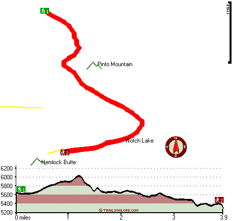
Trailhead 1 to Trailhead 2:
Total hiking length = 3.9 miles
Total climbing distance = 1.5 miles
Difficulty : Medium
Casual Hiking Pace:
3.5 hours
Fast Hiking Pace:
2 hours
Trailhead 2 to Trailhead 1:
Total hiking length = 3.9 miles
Total climbing distance = 1.8 miles
Difficulty : Medium
Casual Hiking Pace:
3.5 hours
Fast Hiking Pace:
2 hours
| | Trailhead 1 back to Trailhead 1:
Total hiking length = 7.8 miles
Total climbing distance = 3.3 miles
Difficulty : Difficult
Casual Hiking Pace:
7 hours
Fast Hiking Pace:
4.5 hours
Trailhead 2 back to Trailhead 2:
Total hiking length = 7.8 miles
Total climbing distance = 3.3 miles
Difficulty : Difficult
Casual Hiking Pace:
7 hours
Fast Hiking Pace:
4.5 hours
|
Total elevation difference: 829 feet
|


