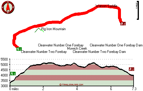
| |
|
| | Oregon has so much to offer the wilderness lovers. We all need to get out in the fresh air once in a while, and Pig Iron Trail in Douglas County, Oregon is a brilliant place to go. Far from modern life you hit upon Pig Iron Trail, and it's one of those places where backcountry hiking is tremendous. There are many great backpacking and hiking trails in Oregon; Pig Iron Trail in Douglas County is one of them. Don’t forget to check for any current restrictions or closures before you go. High temperatures at Pig Iron Trail all through the warmest time of |
|
the year are in the 80's with night lows in the 40's. Highs during the wintertime are commonly in the 40's with winter lows in the 20's overnight here at Pig Iron Trail. This backcountry hiking trail goes through some very different elevations, so keep in mind that you may need
| | to dress differently at different elevations. Pig Iron Trail is a wet site that gets a lot of precipitation; through the month of November you get the most rain around here, and the driest of the months is July. This is a two-ended backpacking trail with two trailheads, so if you can get a ride from someone, you can walk it just one way. There are numerous backpacking and hiking trails in Oregon, and each one is wonderful in its own way. Now, this is roughly a 2-day trek, so better have big backpack to fit all the stuff you need. This is just one of a large | |
|
number of wilderness hiking trails in this vicinity. The wonderful great outdoors hiking trails of the Central Cascade Range are a really fine way to spend quality time in the wilderness. This hiking trail sometimes gets very dry, so don’t forget to check for any current fire restrictions
before you go. The total elevation difference for this backpacking trail is 2,153 feet, and that is about average. Keep in mind that this is a long hiking trail, so don't forget to pack enough supplies. Being 14.6 miles long; it's longer than many backcountry hiking trails. Going
for a trek here in Oregon is so much fun. This great outdoors hiking trail is a great outdoors hiking trail of fine length with an average amount of climbing distance which makes this a very tough wilderness hiking trail for advanced walkers looking for an outstanding challenge.
Briefly
about the general area: But wait, there's more enjoyable things to do in the Central Cascade Range. Whitewater paddling is great on Copland Creek, and paddling on Hills Creek is so much fun. Whitehorse Falls is a picturesque place to take a look at while you're at Pig Iron
Trail, and Pig Iron Trail is a wonderful spot to visit for more than one day, Camas Creek Campground is a wonderful spot to camp nearby. Mowich Creek is one of the streams nearby that might be worth visiting, and Upper Mountain Meadows is a perfect place. If only every place
had this much outdoors fun stuff, what a great globe it would be. At Clearwater Number Two Forebay Dam in the neighborhood of Pig Iron Trail there are some attention-grabbing things to see. You'll need more than a day to look at everything Pig Iron Trail has to offer, you can camp
at Haymaker Campground. Having a splendid time in the Central Cascade Range is simple. Umpqua Hot Springs is a good local attraction, and spots like Thorn Prairie are magnificent to stop by. Maple Creek is near Pig Iron Trail and is always a diversion to go to; Watson Saddle is a splendid place to spend some time.
|
|
Location of Trailhead 1: Latitude 43.2533, Longitude -122.3739 - - Directions and Road Map
Location of Trailhead 2: Latitude 43.2729, Longitude -122.293 - - Directions and Road Map

Trailhead 1 to Trailhead 2: Total hiking length = 7.3 miles Total climbing distance = 3.3 miles Difficulty : Difficult Casual Hiking Pace:
6.5 hours
Fast Hiking Pace:
3.5 hours
Trailhead 2 to Trailhead 1: Total hiking length = 7.3 miles Total climbing distance = 3.3 miles Difficulty : Difficult Casual Hiking Pace:
6.5 hours
Fast Hiking Pace:
3.5 hours
| | Trailhead 1 back to Trailhead 1: Total hiking length = 14.6 miles Total climbing distance = 6.6 miles Difficulty : Difficult Casual Hiking Pace:
2 days
Fast Hiking Pace:
8.5 hours
Trailhead 2 back to Trailhead 2: Total hiking length = 14.6 miles Total climbing distance = 6.6 miles Difficulty : Difficult Casual Hiking Pace:
2 days
Fast Hiking Pace:
8.5 hours
|
Total elevation difference: 2153 feet

Best Western Oakridge Inn, Oakridge
|
26 miles away
This Oakridge, Oregon hotel offers a complimentary continental breakfast each morning and convenient access to a variety of outdoor activities. Discover the Best Western Oakridge Inn, nestled agains...
|
| |
|
User input for Pig Iron Trail, Central Cascade Range, Douglas County, Oregon:

Outdoors Recreation Near Klamath Falls, Oregon Very comprehensive list of a variety of outdoors recreation in the vicinity of Klamath Falls, Oregon, the metro area neareast to Pig Iron Trail. Find info on campgrounds, hiking trails, ski resorts, lakes, beaches, parks, whitewater and more.
More Hotels and Campgrounds Near Pig Iron Trail, Central Cascade Range, Douglas County, Oregon
| |
| |
 |
|
| These outdoors activities are available near Pig Iron Trail. |
| | Trails Near Pig Iron Trail:
 |
Dog Prairie Trail, Douglas County
County
, 3 miles away, 6.5 hiking miles, 2782 feet elevation difference |
 |
Calapooya Trail, Douglas County
County
, 4 miles away, 3.3 hiking miles, 1869 feet elevation difference |
 |
Mountain Meadows Trail, Douglas County
County
, 5 miles away, 2.2 hiking miles, 1752 feet elevation difference |
 |
Rough Creek Trail, Douglas County
County
, 5 miles away, 5.2 hiking miles, 2837 feet elevation difference |
 |
Bradley Trail, Douglas County
County
, 7 miles away, 5.2 hiking miles, 1195 feet elevation difference |
 |
Rodley Butte Trail, Douglas County
County
, 8 miles away, 9.4 hiking miles, 2918 feet elevation difference |
 |
Grave Creek Trail, Douglas County
County
, 8 miles away, 6.2 hiking miles, 3150 feet elevation difference |
|
| | Whitewater Near Pig Iron Trail:
 |
Copland Creek, Douglas County
County
, 14 miles away, Class IV(V) - 5.7 miles long (Second Bridge to North Umpqua) |
 |
Hills Creek, Lane County
County
, 20 miles away, Class IV - 6 miles long (6 mi above Reservoir) |
 |
Rogue River - North Fork, Jackson County
County
, 22 miles away, Class IV - 3 miles long (Natural Bridge to Woodruff Bridge) |
 |
Steamboat Creek, Douglas County
County
, 22 miles away, Class II+(IV) - 9.5 miles long (City Creek to Steamboat Falls) |
 |
Salt Creek, Lane County
County
, 23 miles away, Class III-IV - 7.2 miles long (McCredie Hot Springs to Rigdon Road Bridge) |
|
|
|
 |
|