| |
This hiking and backpacking trail has two trailheads, so if you can get a ride from someone, you can hike it just one way. The total elevation difference for this hiking and backpacking trail is 926 feet which is a lower than average number. This vicinity does get very dry sometimes, so do check for current fire restrictions before you go if you plan to bring a stove or make a camp fire. With its 11 miles of walking distance; it's longer than many great outdoors hiking trails. Pearson Trail is quite long, so make sure you bring plenty of supplies. Now, this is roughly a 1.5-day backcountry hike, so better have big a backpack to fit all the stuff you need. You spend the whole hike in roughly the same elevation zone, so you get pretty much the same conditions along the whole great outdoors hiking trail.
|
Trailhead 1 to Trailhead 2:
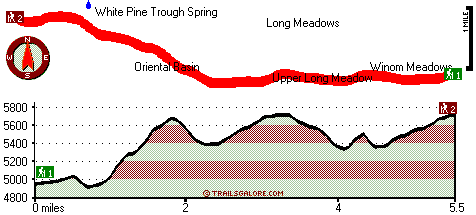
Total hiking length = 5.5 miles
Total climbing distance = 3.4 miles
Difficulty : Medium
Casual Hiking Pace:
5.5 hours
Fast Hiking Pace:
3 hours
Trailhead 2 to Trailhead 1:
Total hiking length = 5.5 miles
Total climbing distance = 1.6 miles
Difficulty : Easy
Casual Hiking Pace:
4.5 hours
Fast Hiking Pace:
2.5 hours
| | Trailhead 1 back to Trailhead 1:
Total hiking length = 11 miles
Total climbing distance = 5 miles
Difficulty : Difficult
Casual Hiking Pace:
1.5 days
Fast Hiking Pace:
6.5 hours
Trailhead 2 back to Trailhead 2:
Total hiking length = 11 miles
Total climbing distance = 5 miles
Difficulty : Difficult
Casual Hiking Pace:
1.5 days
Fast Hiking Pace:
6.5 hours
|
Total elevation difference: 926 feet
|


