| |
|
| | Each one of the many backpacking and hiking trails of Oregon is lovely in its own way. Alright, enough of spending all this time inside a building, time to get out, and Panther Trail in Douglas County, Oregon is a really wonderful site to spend some time. Here in Oregon backcountry backpacking is always a cool thing to do. Don’t forget to check for any current restrictions or closures before you go. Panther Trail is a relatively wet place mostly with lots of rainfall; November is the wettest month with most rain, and July is when it's the driest. Panther |
|
Trail is not very next to Eugene-Springfield at all, but it sure is a a nice backcountry hiking trail. At parts of the year this area sees very little rain, so do check for current fire restrictions before you go if you plan to bring a stove or make a camp fire. There are so many
| | fine backpacking and hiking trails for backcountry backpacking in Oregon, and Panther Trail in Douglas County is one of them. Some parts of Panther Trail are much higher up than other parts of the backcountry hiking trail, so keep in mind that you may need to dress differently at different elevations. No chance of getting bored in Oregon if you like the outdoors. Panther Trail is quite long, so don't forget to pack enough supplies. Through the warmest time of the year at Panther Trail highs are frequently in the 80's. Once the sun is down it drops down | |
|
to the 40's. The winter brings highs down to the 40's, and overnight lows in the 30's for Panther Trail. The backpacking trails of the Central Cascade Range are the best way to enjoy these mountains. Now, this is roughly a 2.5-day backcountry hike, so make sure you've got all your
overnight gear packed. The total elevation difference for Panther Trail is 3,150 feet which is a higher than average number. Panther Trail is a backpacking trail of perfect length with an average amount of climbing distance which makes it a brilliant backcountry trail for experienced
backcountry hikers in tremendous shape. There are two trailheads to chose from, one in each end, so backpacking it one way is an option if you can arrange for a ride back. With its 18.6 miles of walking distance; it's considered a longer backcountry hike. There are so many backcountry
trails in this vicinity.
Briefly about the general area: If you came to camp Buckhead Mountain Campground is a good site to do that. Yeah, come up here to the Central Cascade Range for a splendid time. A quick tour to Station Creek near Panther Trail is a magnificent
idea, and if you come at the right time of year, Umpqua River - North offers some perfect whitewater. Be careful coming to the Central Cascade Range, you might not ever wanna go back home again. There's so much to do here at Panther Trail that you need to camp here for a while,
River View RV Park is a splendid site for that, and a tour to Winslow Cabin Spring will fill your soul with tremendous feelings. Limpy Prairie is a glorious location, and whitewater paddling is not for everyone but if it's for you then, we recommend Steamboat Creek. Just can't
get enough of Panther Trail. South Limpy Prairie is a nice site to check out, and of course Steamboat Creek flows through this vicinity. You don't ought to go far from Panther Trail to enjoy Umpqua National Forest; you must check out Bloody Point when you're here. Since you're here at Panther Trail why not check out Black Gorge It's always splendid to stop by Little Falls.
|
|
Location of Trailhead 1: Latitude 43.343, Longitude -122.7346 - - Directions and Road Map
Location of Trailhead 2: Latitude 43.273, Longitude -122.7509 - - Directions and Road Map

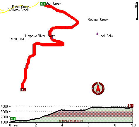
Trailhead 1 to Trailhead 2: Total hiking length = 9.3 miles Total climbing distance = 4.8 miles Difficulty : Difficult Casual Hiking Pace:
9 hours
Fast Hiking Pace:
5 hours
Trailhead 2 to Trailhead 1: Total hiking length = 9.3 miles Total climbing distance = 3 miles Difficulty : Difficult Casual Hiking Pace:
7.5 hours
Fast Hiking Pace:
4 hours
| | Trailhead 1 back to Trailhead 1: Total hiking length = 18.6 miles Total climbing distance = 7.8 miles Difficulty : Difficult Casual Hiking Pace:
2.5 days
Fast Hiking Pace:
2 days
Trailhead 2 back to Trailhead 2: Total hiking length = 18.6 miles Total climbing distance = 7.8 miles Difficulty : Difficult Casual Hiking Pace:
2.5 days
Fast Hiking Pace:
2 days
|
Total elevation difference: 3150 feet

Best Western Oakridge Inn, Oakridge
|
28 miles away
This Oakridge, Oregon hotel offers a complimentary continental breakfast each morning and convenient access to a variety of outdoor activities. Discover the Best Western Oakridge Inn, nestled agains...
|
| |
Moonstone Village Green Resort, Cottage Grove
|
33 miles away
Village Green Resort is located off Interstate 5, in Cottage Grove. The resort is six miles from the covered bridges, and approximately 30 miles from Eugene Airport. We are less than a mile from two g...
|
|
User input for Panther Trail, Central Cascade Range, Douglas County, Oregon:

Outdoors Recreation Near Eugene-Springfield, Oregon Very comprehensive list of a variety of outdoors recreation in the vicinity of Eugene-Springfield, Oregon, the metro area neareast to Panther Trail. Find info on campgrounds, hiking trails, ski resorts, lakes, beaches, parks, whitewater and more.
More Hotels and Campgrounds Near Panther Trail, Central Cascade Range, Douglas County, Oregon
| |
| |
 |
|
| These outdoors activities are available near Panther Trail. |
| | Trails Near Panther Trail:
 |
Mott Trail, Douglas County
County
, 2 miles away, 7 hiking miles, 3396 feet elevation difference |
 |
Williams Creek Trail, Douglas County
County
, 5 miles away, 5.2 hiking miles, 2407 feet elevation difference |
 |
Red Butte Trail, Douglas County
County
, 7 miles away, 8.6 hiking miles, 1909 feet elevation difference |
 |
Twin Lakes Trail, Douglas County
County
, 9 miles away, 11.2 hiking miles, 4061 feet elevation difference |
 |
Leach Camp Trail, Douglas County
County
, 10 miles away, 1.1 hiking miles, 1608 feet elevation difference |
 |
Deception Way, Douglas County
County
, 10 miles away, 6 hiking miles, 1482 feet elevation difference |
 |
Francis Way, Lane County
County
, 10 miles away, .6 hiking miles, 136 feet elevation difference |
|
| | Whitewater Near Panther Trail:
 |
Umpqua River - North, Douglas County
County
, 2 miles away, Class III - 25.5 miles long (Soda Springs to Deadline Falls) |
 |
Steamboat Creek, Douglas County
County
, 4 miles away, Class IV - 6 miles long (Steamboat Falls to Canton Creek Campground) |
 |
Canyon Creek, Douglas County
County
, 5 miles away, Class III-IV - 9 miles long (Confluence with Pass Creek to Steamboat Creek) |
 |
Little River, Douglas County
County
, 6 miles away, Class -blank- - 8 miles long (FS Road 165 to White Creek Campground) |
 |
Steamboat Creek, Douglas County
County
, 6 miles away, Class II+(IV) - 9.5 miles long (City Creek to Steamboat Falls) |
|
| | Hotels Near Panther Trail:
 |
Best Western Oakridge Inn, Oakridge
, 28 miles away |
 |
Moonstone Village Green Resort, Cottage Grove
, 33 miles away |
 |
Comfort Inn Cottage Grove, Cottage Grove
, 33 miles away |
 |
Holiday Inn Express Cottage Grove, Or, Cottage Grove
, 33 miles away |
 |
Super 8 Creswell, Creswell
, 37 miles away |
|
|
|
 |
|