Oregon hiking trails - Oregon Caves Trail, Klamath Mountains, Josephine County

   
  Oregon Caves Trail is located a pretty lengthy journey from Grants Pass, but it is a fun spot to trek. Each backcountry trail in Oregon is delightful in its own way. Hey, time for a trek don’t you think? Oregon Caves Trail in Josephine County, Oregon is an excellent choice. Backcountry trekking in Oregon is a magnificent way to spend some time. The length of Oregon Caves Trail is on the longer side with an average amount of climbing distance which makes it a perfect great outdoors trail for experienced trekkers in perfect shape. This is a two-ended backpacking
    and hiking trail with two trailheads, so trekking it one way is an option if you can arrange for a ride back. This trek should take you about 1.5 days, so better have big backpack to fit all the stuff you need. With its 11.4 miles of walking distance; it's a long backcountry hiking
trail. Please follow all local rules about fires and camping. Through the long summer days at Oregon Caves Trail temperatures are typically in the 80's while night lows are typically in the 40's. The cold days of the winter come with highs in the 40's; all through the dark hours in the winter at Oregon Caves Trail temperatures plunge to the 30's. This is one of many great outdoors trails in the surrounding vicinity. Oregon has plenty of pleasant backcountry trails; one of them being Oregon Caves Trail in Josephine County. This backpacking and hiking trail  
has a total elevation difference of 1,673 feet which is about average. This neighborhood does get very dry sometimes, so don’t forget to check for any current fire restrictions before you go. Oregon is a glorious site for outdoors people. Different parts of Oregon Caves Trail are at very different elevations, so keep in mind that you may need to dress differently at different elevations. The great outdoors trails of the Klamath Mountains are a glorious way to explore these highlands. A great deal of rain falls at Oregon Caves Trail; December is the month that gets the most rain while July is generally the driest month. Oregon Caves Trail is quite long, so make sure you bring plenty of supplies.

Briefly about the general area:
Whohoo, so many enjoyable things in one place! The Klamath Mountains is so good! There's whitewater on Elk Creek for all you adrenaline kick people, and close by you stumble on wonderful places like Low Divide. Now, you may feel that's heaps but there's even more entertaining stuff to do here in the Klamath Mountains. Oregon Caves Trail is a place with many visitors from Grants Pass. There's so much to do here at Oregon Caves Trail that you need to camp here for a while, West Branch Campground is a glorious spot for that.
Stay the night at Country Hills Resort. Some of the water close by flows, like Panther Creek, and Oregon Caves National Monument is one of the destinations that are pleasant to check out nearby. It's always perfect to stop by Willow Spring, and Elkhorn Prairie is a tremendous place here at Oregon Caves Trail.
There are some wonderful whitewater spots on Indian Creek Klamath Tributary, and don’t forget to visit Cedar Flat since you're here at Oregon Caves Trail. Yeah, come here to Oregon Caves Trail for a magnificent time. Fourmile Creek is a glorious site to pop by, and Horse Spring is a good local attraction.

Location of Trailhead 1: Latitude 42.1311, Longitude -123.362
- - Directions and Road Map

Location of Trailhead 2: Latitude 42.1017, Longitude -123.4128
- - Directions and Road Map


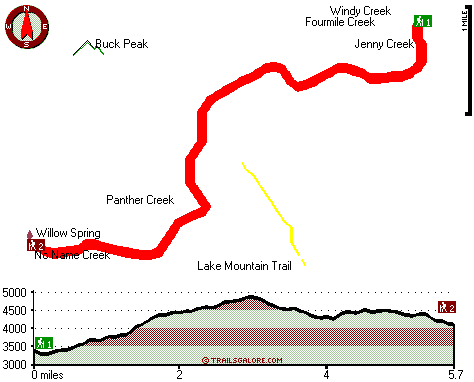
Trailhead 1 to Trailhead 2:
Total hiking length = 5.7 miles
Total climbing distance = 3 miles
Difficulty : Medium
Casual Hiking Pace: 5.5 hours
Fast Hiking Pace: 3 hours

Trailhead 2 to Trailhead 1:
Total hiking length = 5.7 miles
Total climbing distance = 2.1 miles
Difficulty : Medium
Casual Hiking Pace: 5 hours
Fast Hiking Pace: 2.5 hours
    Trailhead 1 back to Trailhead 1:
Total hiking length = 11.4 miles
Total climbing distance = 5.1 miles
Difficulty : Difficult
Casual Hiking Pace: 1.5 days
Fast Hiking Pace: 6.5 hours

Trailhead 2 back to Trailhead 2:
Total hiking length = 11.4 miles
Total climbing distance = 5.1 miles
Difficulty : Difficult
Casual Hiking Pace: 1.5 days
Fast Hiking Pace: 6.5 hours

Total elevation difference: 1673 feet


Riverside Inn, Grants Pass
17 miles away
As the largest hotel on the Rogue River-Riverside Inn resort and conference center is a preferred location for lodging needs in the area. The Inn boasts spacious guestrooms -all of them with private b...
  
Holiday Inn Express GRANTS PASS, Grants Pass
17 miles away
The Holiday Inn Express Grants Pass is conveniently located at the junction of Interstate 5 and the Redwood Hwy (Hwy 199). Our lodging offers you easy access to Rogue River thrills, antique shopping, ...
User input for Oregon Caves Trail, Klamath Mountains, Josephine County, Oregon:

Submit Input:
Your Name:
Write or Paste Input here:

Upload picture:      Review Guidelines


Outdoors Recreation Near Grants Pass, Oregon
Very comprehensive list of a variety of outdoors recreation in the vicinity of Grants Pass, Oregon, the metro area neareast to Oregon Caves Trail. Find info on campgrounds, hiking trails, ski resorts, lakes, beaches, parks, whitewater and more.

Current weather conditions at Oregon Caves Trail, Klamath Mountains, Josephine County, Oregon
WXPort

Local climate location: CAVE JUNCTION 1 miles away

Best Western Grants Pass Inn, Grants Pass
18 miles away
Situated at the junction of Interstate 5 and Highway 199, this Grants Pass hotel is just minutes from the famous Rogue River in Oregon. The Best Western Grants Pass Inn is surrounded by beautiful mo...

Sweet Breeze Inn, Grants Pass
18 miles away
Welcome to the Sweet Breeze Inn. Our motel in Grants Pass proudly offers all non smoking rooms. There is an outside covered garden patio for those that do indulge. Wireless Internet Access is availabl...

More Hotels and Campgrounds Near Oregon Caves Trail, Klamath Mountains, Josephine County, Oregon

OTHER_INFO
  Klamath Mountains Campgrounds
Complete list of all the campgrounds in the Klamath Mountains.

Klamath Mountains Outdoors Info
Complete outdoors info for the Klamath Mountains.

Oregon Hiking Trails
Complete list of all hiking trails in Oregon

Books about hiking trails in Oregon
List of books available on Amazon.com about hiking trails in Oregon.

Oregon Outdoors Index
This is a very comprehensive index of outdoors activities in the great state of Oregon.


TOPO
High quality water resistant topo map of Oregon Caves Trail, Klamath Mountains, Josephine County, Oregon.

OUTDOORS_GUIDE
These outdoors activities are available near Oregon Caves Trail.
 Trails Near Oregon Caves Trail:
Lake Mountain Trail, Josephine County County , 1 miles away, 5.3 hiking miles, 1760 feet elevation difference
Limestone Trail, Josephine County County , 2 miles away, 4.4 hiking miles, 2926 feet elevation difference
East Fork Sucker Creek Trail, Josephine County County , 3 miles away, 6.4 hiking miles, 3375 feet elevation difference
Grayback Clapboard Trail, Josephine County County , 4 miles away, 8.4 hiking miles, 2882 feet elevation difference
Green Valley Trail, Josephine County County , 5 miles away,  1.4 hiking miles, 810 feet elevation difference
Boundary Trail, Josephine County County , 5 miles away, 8.6 hiking miles, 1741 feet elevation difference
Sucker Creek Trail, Josephine County County , 5 miles away,  8.2 hiking miles, 1978 feet elevation difference
 Camp Grounds Near Oregon Caves Trail:
Country Hills Resort, Cave Junction, 9 miles away
West Branch Campground, Siskiyou County, 11 miles away
Lake Selmac RV Resort, Selma, 15 miles away
Klamath RV Park, Happy Camp, 16 miles away
Cook and Green Campground, Siskiyou County, 16 miles away
 Whitewater Near Oregon Caves Trail:
Indian Creek Klamath Tributary, Siskiyou County County , 15 miles away, Class III - 7.6 miles long (confluence South and East Fork to Klamath River)
Elk Creek, Siskiyou County County , 19 miles away, Class I-IV - 5 miles long (Elk Creek Road to Klamath River)
Klamath River, Siskiyou County County , 21 miles away, Class III - 36 miles long (Sarah Totten Campground to Happy Camp)
Klamath River, Siskiyou County County , 22 miles away, Class III+(IV) - 18 miles long (Happy Camp to Coon Creek)
Trace Creek, Siskiyou County County , 22 miles away, Class IV-V - 7 miles long (Bear Pen Creek to Klamath River)
 National Parks Near Oregon Caves Trail:
Oregon Caves National Monument, Cave Junction - OR , 16 miles away
Redwood National and State Parks, Crescent City - CA , 57 miles away
 Hotels Near Oregon Caves Trail:
Riverside Inn, Grants Pass , 17 miles away
Holiday Inn Express GRANTS PASS, Grants Pass , 17 miles away
Best Western Grants Pass Inn, Grants Pass , 18 miles away
Sweet Breeze Inn, Grants Pass , 18 miles away
Comfort Inn Grants Pass, Grants Pass , 18 miles away
 Lakes Near Oregon Caves Trail
Fish Lake, Josephine County , 5 miles away

Outdoors related information copyright © Stratus-Pikpuk, Inc. - Detailed hotel information copyright © Interactive Hotel Solutions