Oregon hiking trails - Olallie Trail, Central Cascade Range, Lane County

   
  There are numerous hiking and backpacking trails in Oregon, and each one has something unique to offer. When you're here in Oregon hiking along one of its hiking and backpacking trails never gets boring. Hiking trails for hiking, and backpacking can be found all over Oregon, and Olallie Trail in Lane County is one of them. This is a trail that is quite long, so make sure you bring plenty of supplies. This is just one of a large number of hiking trails in this area. Olallie Trail is 10.4 miles long; it's considered a longer backcountry walk. Sometimes this
    trail gets really dry, so don’t forget to check for any current fire restrictions before you go. The time needed for this walk is roughly 9 hours, but you never know stuff could go wrong and you could get stuck so be prepared for that. Olallie Trail is not very close to Bend at
all, but it is an enjoyable spot to trek. Please follow all local rules about fires and camping. Olallie Trail gets a large amount of water; the month with most of the rain is December while July is the month with the least amount of precipitation. Olallie Trail is a one trailhead hiking trail, so in and out is the way to walk it normally. All through the summertime months here at Olallie Trail, high temperatures commonly reach the 80's. When the night sets in temperatures plunge down into the 40's. High temperatures during the wintertime are normally in  
the 40's, and overnight lows during the wintertime for Olallie Trail tend to be in the 20's. Backcountry backpacking here in the Central Cascade Range is a very great way to see these hills. The great outdoors hiking trail stays roughly within the same elevation zone the whole time, so you get pretty much the same conditions along the whole great outdoors hiking trail. If you are in Oregon during hiking season you have to go hiking. When was the last time you got out in the great outdoors a bit? Olallie Trail in Lane County, Oregon is just the spot. The length of Olallie Trail is on the longer side having an average number of uphill miles which makes this hiking trail glorious for hard core backpackers looking for adventure. This hiking trail has a total elevation difference of 735 feet which is lower than average.

Briefly about the general area:
McKenzie River - South Fork is a tremendous whitewater spot close to Olallie Trail, and Olallie Trail is perfect enough to spend more than a day at, Twin Springs Campground is a perfect local campground. You just must love the Central Cascade Range. Don’t forget to take a look at Olallie Meadows since you're here at Olallie Trail, and Corral Draw is another brilliant place to explore close by.
That right there is heaps already, but it continues; Olallie Trail has it all. Do set aside some time for Bear Flat if you're here at Olallie Trail; a magnificent place to camp here at Olallie Trail is Patio RV Park. Don't forget to take a good little tour to Mosquito Creek, and you can run the rapids of Horse Creek. Why not go to close by Eugene Creek since you're here at Olallie Trail, and Beeler Spring is always fun to check out.
Man, is there a load of amusing things to do in the Central Cascade Range.

Location of Trailhead: Latitude 44.0629, Longitude -122.061
- - Directions and Road Map

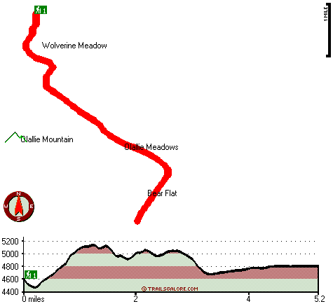
Total in and out hiking length = 10.4 miles

Total climbing distance = 4.3 miles

Difficulty : Difficult

Casual Hiking Pace: 9 hours

Fast Hiking Pace: 6 hours

Total elevation difference: 735 feet


Lodge at Suttle Lake, Sisters
32 miles away
We are not your typical hotel. Nestled in the heart of the Deschutes National Forest amid soaring pines. Suttle Lake Resort provides an enchanted escape. Our resorts mountain views and pristine lake w...
  
Best Western Oakridge Inn, Oakridge
34 miles away
This Oakridge, Oregon hotel offers a complimentary continental breakfast each morning and convenient access to a variety of outdoor activities. Discover the Best Western Oakridge Inn, nestled agains...
User input for Olallie Trail, Central Cascade Range, Lane County, Oregon:

Submit Input:
Your Name:
Write or Paste Input here:

Upload picture:      Review Guidelines


Outdoors Recreation Near Bend, Oregon
Very comprehensive list of a variety of outdoors recreation in the vicinity of Bend, Oregon, the metro area neareast to Olallie Trail. Find info on campgrounds, hiking trails, ski resorts, lakes, beaches, parks, whitewater and more.

Current weather conditions at Olallie Trail, Central Cascade Range, Lane County, Oregon
WXPort

Local climate location: MC KENZIE BRIDGE R S 4 miles away

Best Western Ponderosa Lodge, Sisters
36 miles away
Offers a refreshing environment with renovated rooms, new deluxe suites and smoke-free accommodations. The perfect choice while traveling the 'Gateway to the Cascades', ideally located on 14 acres sur...

Five Pine Lodge, Sisters
37 miles away
Lodging in Sisters, Oregon, at FivePine Lodge and Spa is a vacation back in time to Central Oregon's golden era of travel with every modern luxury. Whether you're practicing Tai-Chi atop Eagle Rock, p...

More Hotels and Campgrounds Near Olallie Trail, Central Cascade Range, Lane County, Oregon

OTHER_INFO
  Central Cascade Range Campgrounds
Complete list of all the campgrounds in the Central Cascade Range.

Central Cascade Range Outdoors Info
Complete outdoors info for the Central Cascade Range.

Oregon Hiking Trails
Complete list of all hiking trails in Oregon

Books about hiking trails in Oregon
List of books available on Amazon.com about hiking trails in Oregon.

Oregon Outdoors Index
This is a very comprehensive index of outdoors activities in the great state of Oregon.


TOPO
High quality water resistant topo map of Olallie Trail, Central Cascade Range, Lane County, Oregon.

OUTDOORS_GUIDE
These outdoors activities are available near Olallie Trail.
 Trails Near Olallie Trail:
Dealy Way, Lane County County , 6 miles away,  11.8 hiking miles, 2050 feet elevation difference
Elk Creek Trail, Lane County County , 6 miles away,  10.6 hiking miles, 2067 feet elevation difference
Saddle Trail, Lane County County , 6 miles away,  2.4 hiking miles, 1641 feet elevation difference
Packsaddle Mountain Trail, Lane County County , 7 miles away,  14.8 hiking miles, 3646 feet elevation difference
Pyramid Trail, Lane County County , 7 miles away,  8.8 hiking miles, 3174 feet elevation difference
Lakeside Trail, Lane County County , 7 miles away,  16 hiking miles, 2351 feet elevation difference
Rebel Rock Trail, Lane County County , 7 miles away,  10.6 hiking miles, 3608 feet elevation difference
 Camp Grounds Near Olallie Trail:
Twin Springs Campground, Lane County, 7 miles away
Patio RV Park, Blue River, 12 miles away
Echo Campground, Lane County, 14 miles away
Holiday Farm RV Resort, Blue River, 15 miles away
East Lake Resort and RV Parks, La Pine, 18 miles away
 Whitewater Near Olallie Trail:
Horse Creek, Lane County County , 6 miles away, Class III - 11 miles long (above Separation Creek to McKenzie River)
McKenzie River - South Fork, Lane County County , 10 miles away, Class III-IV - 6.2 miles long (Dutch Oven Camp to Cougar Reservoir)
Blue River, Linn/ Lane County County , 16 miles away, Class IV-V - 4 miles long (Quentin Creek to Blue River Reservoir)
Lookout Creek, -blank- County County , 17 miles away, Class III-IV - 2.5 miles long (2.5 miles above Blue River to Blue River)
Quartz Creek, Lane County County , 21 miles away, Class II-IV - 5 miles long (Quartz Creek Road Mile 7.5 Bridge to Mile 2 Bridge)
 National Parks Near Olallie Trail:
Crater Lake National Park, Crater Lake - OR , 57 miles away
 Hotels Near Olallie Trail:
Lodge at Suttle Lake, Sisters , 32 miles away
Best Western Oakridge Inn, Oakridge , 34 miles away
Best Western Ponderosa Lodge, Sisters , 36 miles away
Five Pine Lodge, Sisters , 37 miles away
Best Western Newberry Station, La Pine , 42 miles away

Outdoors related information copyright © Stratus-Pikpuk, Inc. - Detailed hotel information copyright © Interactive Hotel Solutions