| |
|
| | Every single Oregon backpacking and hiking trail is different from the others. No chance of getting bored in Oregon if you like nature. Good backpacking and hiking trails in Oregon are in abundance, and North Fork Trail in Umatilla County is one of them. This hiking and backpacking trail has a total elevation difference of 2,991 feet which is higher than average. Hiking and backpacking trails like this one here in the Blue Mountains are a very great way to see these summits. This is a neighborhood covered with lots of great outdoors trails. Backcountry trekking |
|
in Oregon is a wonderful way to spend some time. Being 18 miles long; it's considered a longer backcountry hike. Sometimes this hiking and backpacking trail gets really dry, so do check for current fire restrictions before you go if you plan to bring a stove or make a camp fire.
| | North Fork Trail is a backcountry trail relatively far from La Grande, but it sure is a a tremendous backcountry trail. Around North Fork Trail you don’t get a lot of rain; the month of November is the wettest with most of the rain, and July meanwhile is the driest month. Keep in mind that this is a long hiking and backpacking trail, so don't forget to pack enough supplies. Don’t forget to check for any current restrictions or closures before you go. Through the summertime highs here at North Fork Trail get into the 80's while overnight lows are ordinarily | |
|
in the 50's. Daytime highs throughout the wintertime are in the 40's while the cold winter nights at North Fork Trail are in the 20's. This is a two-ended hiking and backpacking trail with two trailheads which means you have the option of backcountry trekking it one way if you
have someone to pick you up at the other end. North Fork Trail is a very long backpacking and hiking trail with an average amount of climbing distance which makes this great outdoors trail tremendous for hard core backpackers looking for adventure. This great outdoors trail goes
through some very different elevations which of course means you need to be prepared for different conditions on different parts of the great outdoors trail. Time to get out, and breathe some fresh air, and North Fork Trail in Umatilla County, Oregon is a really fine place to spend
some time. This backcountry walk should take you about 2.5 days, so better have big backpack to fit all the stuff you need.
Briefly about the general area: Get wet paddling on Grande Ronde River, and a good place is Bear Trap Canyon. North Fork Trail truly is in the
middle of a pretty outdoors paradise. Places like Table Glade are pleasant to take a look at, and East Fork Coyote Creek is in close proximity to North Fork Trail and is always a joy to visit. So much amusing stuff to do in the Blue Mountains, not enough time. Tamarack Basin
is a great spot. This place, the Blue Mountains, has so much outdoors amusing things. There's a wonderful forest near North Fork Trail called Umatilla National Forest, and a short tour to Dick Spring is always worthwhile. A splendid place to camp here at North Fork Trail is Elk
Campground, and English Spring is an inspiring site to stop at while you're here. Why not camp at South Fork Campground since you're here at North Fork Trail, and some close by water includes West Fork Coyote Creek.
|
|
Location of Trailhead 1: Latitude 45.7263, Longitude -118.1858 - - Directions and Road Map
Location of Trailhead 2: Latitude 45.7552, Longitude -118.0851 - - Directions and Road Map

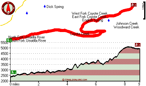
Trailhead 1 to Trailhead 2: Total hiking length = 9 miles Total climbing distance = 5 miles Difficulty : Difficult Casual Hiking Pace:
8.5 hours
Fast Hiking Pace:
5 hours
Trailhead 2 to Trailhead 1: Total hiking length = 9 miles Total climbing distance = 3 miles Difficulty : Difficult Casual Hiking Pace:
7.5 hours
Fast Hiking Pace:
4 hours
| | Trailhead 1 back to Trailhead 1: Total hiking length = 18 miles Total climbing distance = 8 miles Difficulty : Difficult Casual Hiking Pace:
2.5 days
Fast Hiking Pace:
2 days
Trailhead 2 back to Trailhead 2: Total hiking length = 18 miles Total climbing distance = 8 miles Difficulty : Difficult Casual Hiking Pace:
2.5 days
Fast Hiking Pace:
2 days
|
Total elevation difference: 2991 feet

Walla Walla Super 8 Motel, Walla Walla
|
20 miles away
The Super 8 in Walla Walla is located just off Hwy. 12 Exit Wilbur Ave. The property features 101 rooms, Super Start Breakfast, Free Wireless Hi Speed Internet, Indoor Pool and Spa, Copy & Fax servic...
|
| |
Lagrande Super 8 Motel, La Grande
|
20 miles away
Welcome to the Super 8 LaGrange. Our property is AAA Approved, we offer our guests a SuperStart breakfast, indoor heated pool and hot tub, high speed internet, cable TV w/HBO, ESPN, in-room coffee ma...
|
|
User input for North Fork Trail, Blue Mountains, Umatilla County, Oregon:

Outdoors Recreation Near La Grande, Oregon Very comprehensive list of a variety of outdoors recreation in the vicinity of La Grande, Oregon, the metro area neareast to North Fork Trail. Find info on campgrounds, hiking trails, ski resorts, lakes, beaches, parks, whitewater and more.
More Hotels and Campgrounds Near North Fork Trail, Blue Mountains, Umatilla County, Oregon
| |
| |
 |
|
| These outdoors activities are available near North Fork Trail. |
| | Trails Near North Fork Trail:
 |
Lick Creek Trail, Umatilla County
County
, 4 miles away, 2.9 hiking miles, 2202 feet elevation difference |
 |
Hale Spring Trail, Union County
County
, 12 miles away, 2.4 hiking miles, 1734 feet elevation difference |
 |
Five Points Trail, Union County
County
, 13 miles away, 5.7 hiking miles, 2090 feet elevation difference |
 |
Summit Mount Emily Trail, Union County
County
, 14 miles away, 6.3 hiking miles, 1892 feet elevation difference |
 |
Intake Trail, Umatilla County
County
, 14 miles away, 1.5 hiking miles, 1716 feet elevation difference |
 |
Evans Trail, Union County
County
, 15 miles away, 4.7 hiking miles, 1956 feet elevation difference |
 |
Intake Trail, Columbia County
County
, 20 miles away, 6.3 hiking miles, 1578 feet elevation difference |
|
| | Whitewater Near North Fork Trail:
 |
Grande Ronde River, Union County
County
, 18 miles away, Class I - 32 miles long (Riverside City Park to Elgin) |
 |
Grande Ronde River, Union County
County
, 18 miles away, Class II-IV - 13 miles long (Elgin to Palmer Junction) |
 |
Grande Ronde River, Union County
County
, 19 miles away, Class II-IV - 9 miles long (Hilgard Junction State Park to Riverside City Park) |
 |
Grande Ronde River, Union County
County
, 23 miles away, Class II - 8 miles long (Red Bridge State Park to Hilgard Junction State Park) |
 |
Grande Ronde River, Union County
County
, 31 miles away, Class II-IV - 17 miles long (Tony Vey Meadow to Red Bridge State Park) |
|
| | Hotels Near North Fork Trail:
 |
Walla Walla Super 8 Motel, Walla Walla
, 20 miles away |
 |
Lagrande Super 8 Motel, La Grande
, 20 miles away |
 |
Best Western Rama Inn & Suites, La Grande
, 20 miles away |
 |
La Grande Travelodge, La Grande
, 21 miles away |
 |
Walla Walla East Main St. Travelodge, Walla Walla
, 21 miles away |
|
|
|
 |
|