| |
This backpacking trail has two trailheads which means you have the option of trekking it one way if you have someone to pick you up at the other end. Nohorn Trail has a total elevation difference of 472 feet which is lower than average. You should count on this backcountry trek taking about 3.5 hours, but you never know stuff could go wrong and you could get stuck so be prepared for that. Nohorn Trail is 3.8 miles long it's a shorter type backcountry hike. You spend the whole backcountry hike in roughly the same elevation zone which means the conditions are about the same from start to finish. This great outdoors trail is not that long but you should still bring some emergency supplies just in case something happens.
|
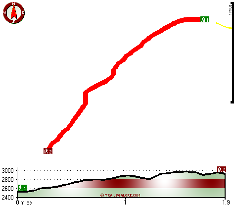
Trailhead 1 to Trailhead 2:
Total hiking length = 1.9 miles
Total climbing distance = 1.2 miles
Difficulty : Medium
Casual Hiking Pace:
2 hours
Fast Hiking Pace:
1 hours
Trailhead 2 to Trailhead 1:
Total hiking length = 1.9 miles
Total climbing distance = .5 miles
Difficulty : Easy
Casual Hiking Pace:
1.5 hours
Fast Hiking Pace:
1 hours
| | Trailhead 1 back to Trailhead 1:
Total hiking length = 3.8 miles
Total climbing distance = 1.7 miles
Difficulty : Medium
Casual Hiking Pace:
3.5 hours
Fast Hiking Pace:
2 hours
Trailhead 2 back to Trailhead 2:
Total hiking length = 3.8 miles
Total climbing distance = 1.7 miles
Difficulty : Medium
Casual Hiking Pace:
3.5 hours
Fast Hiking Pace:
2 hours
|
Total elevation difference: 472 feet
|


