| |
Mount Ray Trail has a total elevation difference of 1,058 feet which is an average number. Sometimes this wilderness hiking trail gets really dry, so make sure you check current conditions and fire restrictions with local forest authorities before you head out. With its 4.6 miles of walking distance it's an average length backcountry trail. There is only one trailhead, so in and out is the way to trek it normally. Mount Ray Trail stays roughly within the same elevation zone the whole time, so you won’t have to worry about different climate zones along your hike. Even though this is not a very long wilderness hiking trail you should still bring some emergency supplies just in case something happens. You should count on this backcountry walk taking about 4 hours, but you never know stuff could go wrong and you could get stuck so be prepared for that.
|
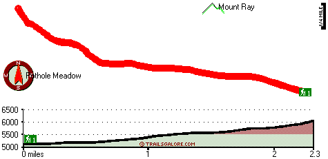
Total in and out hiking length = 4.6 miles
Total climbing distance = 1.8 miles
Difficulty : Medium
Casual Hiking Pace:
4 hours
Fast Hiking Pace:
2.5 hours
Total elevation difference: 1058 feet
|


