| |
|
| | Outdoors folks generally like this part of Oregon. Each one of the many wilderness trails of Oregon has its own character. When you're here in Oregon hiking along one of its wilderness trails is always a cool thing to do. Mount Bailey Trail goes through some very different elevations, and that means that some parts of the backcountry trail could be very different from other parts of it. At Mount Bailey Trail during the warm months highs are in the 80's. When the night sets in temperatures drop down into the 40's. The winter comes with highs in the 40's, and |
|
nighttime lows at Mount Bailey Trail during the winter regularly drop into the 20's. The total elevation difference for this great outdoors hiking trail is 3,466 feet which is higher than average. Gotta get out of the urban center man, and Mount Bailey Trail in Douglas County,
| | Oregon is a really great place to spend some time. Don’t forget to check for any current restrictions or closures before you go. The backpacking and hiking trails of the Southern Cascade Range are a very great way to see these summits. You should count on this hike taking about 7.5 hours, but of course some people walk a bit slower and some a bit faster. This great outdoors trail sometimes gets very dry, so make sure you check current conditions and fire restrictions with local forest authorities before you head out. Mount Bailey Trail is quite long, | |
|
so do pack enough food to last the whole trip. Mount Bailey Trail is a wet location that gets a lot of rain; November is when you get the most rain here, and July on the other hand is the driest. Good wilderness trails in Oregon are in abundance, and Mount Bailey Trail in Douglas
County is one of them. There are so many trails in this vicinity. Mount Bailey Trail has only one trailhead, so you're looking at an in and out trek. Mount Bailey Trail is not very in the neighborhood of Klamath Falls at all, but many folks like to walk here to be in the neighborhood
of the great outdoors. This backpacking and hiking trail is a mid length backpacking and hiking trail with an average amount of climbing distance which makes it a perfect trail for experienced backcountry hikers in tremendous shape. Being 9 miles long it's an average length backcountry
trail.
Briefly about the general area: Spend the day on the beach at Pumice Beach while you're here at Mount Bailey Trail; if you came to camp Diamond Lake RV Park is a good place to do that. Don't leave Mount Bailey Trail without first paying a visit to Boundary Springs.
A quick journey to Short Creek right next door to Mount Bailey Trail is a great idea, and stopping by Crater Lake National Park is just something you need to do if you haven't yet. And that's not all the things you can do here in the Southern Cascade Range. It's a delightful idea
to go to Silent Creek, it's in close proximity to Mount Bailey Trail, and camping at Haymaker Campground is always a delightful experience.
|
|
Location of Trailhead: Latitude 43.1237, Longitude -122.1664 - - Directions and Road Map
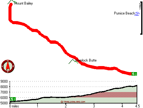
Total in and out hiking length = 9 miles
Total climbing distance = 3.4 miles
Difficulty : Difficult
Casual Hiking Pace:
7.5 hours
Fast Hiking Pace:
5 hours
Total elevation difference: 3466 feet

Best Western Oakridge Inn, Oakridge
|
37 miles away
This Oakridge, Oregon hotel offers a complimentary continental breakfast each morning and convenient access to a variety of outdoor activities. Discover the Best Western Oakridge Inn, nestled agains...
|
| |
|
User input for Mount Bailey Trail, Southern Cascade Range, Douglas County, Oregon:

Outdoors Recreation Near Klamath Falls, Oregon Very comprehensive list of a variety of outdoors recreation in the vicinity of Klamath Falls, Oregon, the metro area neareast to Mount Bailey Trail. Find info on campgrounds, hiking trails, ski resorts, lakes, beaches, parks, whitewater and more.
More Hotels and Campgrounds Near Mount Bailey Trail, Southern Cascade Range, Douglas County, Oregon
| |
|
| These outdoors activities are available near Mount Bailey Trail. |
| | Trails Near Mount Bailey Trail:
 |
Beartrap Trail, Douglas County
County
, 4 miles away, 7.5 hiking miles, 2567 feet elevation difference |
 |
Rodley Butte Trail, Douglas County
County
, 4 miles away, 9.4 hiking miles, 2918 feet elevation difference |
 |
Tipsoo Trail, Douglas County
County
, 6 miles away, 5.2 hiking miles, 886 feet elevation difference |
 |
Beaver Meadows Trail, Douglas County
County
, 7 miles away, 4.2 hiking miles, 526 feet elevation difference |
 |
Thielsen Creek Trail, Douglas County
County
, 7 miles away, 9.2 hiking miles, 1730 feet elevation difference |
 |
Three Lakes Trail, Douglas County
County
, 8 miles away, 4.4 hiking miles, 669 feet elevation difference |
 |
Rim Rock Trail, Douglas County
County
, 9 miles away, 0.8 hiking miles, 586 feet elevation difference |
|
|
|
 |
|