Oregon hiking trails - Mott Trail, Central Cascade Range, Douglas County

   
  Going for a trek here in Oregon is a good way to spend some time. No chance of getting bored in Oregon if you like nature. Each trail in Oregon has something unique to offer. Mott Trail has a total elevation difference of 3,396 feet which is a higher than average number. This region does get very dry sometimes, so make sure you check current conditions and fire restrictions with local forest authorities before you head out. This is one of many backcountry trails in the surrounding neighborhood. This is a hiking trail that is quite long, so do pack enough
    food to last the whole trip. This is a two-ended hiking and backpacking trail with two trailheads, so if you can get a ride from someone, you can backcountry walk it just one way. Wilderness hiking trails for backcountry backpacking, and backpacking can be found all over Oregon,
and Mott Trail in Douglas County is one of them. All the water falling down from the sky makes Mott Trail a wet spot; of all the months in a year November is the one with the most rain while July is typically the driest month. This hiking and backpacking trail goes through some very different elevations, so keep in mind that you may need to dress differently at different elevations. You can't spend all your time indoors you need to get out once in a while, and Mott Trail in Douglas County, Oregon is just the place. Mott Trail is situated a quite long  
trip from Eugene-Springfield, but It's always exciting to backcountry walk here. With its 14 miles of walking distance; it's considered a longer backcountry hike. Don’t forget to check for any current restrictions or closures before you go. This walk should take you about 2 days, so it's an outstanding thing if your backpack is big enough to do the job. Summertime brings highs in the 80's to Mott Trail with nighttime lows in the 40's. Highs during the wintertime are ordinarily in the 40's, and winter nights come with lows in the 30's to Mott Trail. This hiking trail is a hiking trail of great length having an average number of uphill miles which makes it a great backcountry trail for experienced backcountry walkers in good shape. The charming hiking trails of the Central Cascade Range are a magnificent way to explore these hills.

Briefly about the general area:
Some of the water close by flows, like Williams Creek. Man, is there a lot of exciting things to do in the Central Cascade Range. If you come at the right time of year, Canyon Creek offers some great whitewater, and if you came for an overnight stay Smith Springs Campground is a splendid location to camp.
Get yourself into a kayak and hit Umpqua River - North, and Little Falls is a gorgeous location to take a look at while you're at Mott Trail. Whohoo, so many enjoyable things in one place! Mott Trail is so good! Timber Creek is a magnificent local stream, and everybody loves South Limpy Prairie. Winslow Cabin Spring is a glorious local attraction, and a magnificent place close by is Black Gorge.
Willow Flats is a delightful site, and camping is available at River View RV Park. So many exciting things to do here in the Central Cascade Range, too fine to be true. The trees of Umpqua National Forest are a pleasant source of shade on hot summer days; do schedule some time to visit Bloody Point if you have a chance.

Location of Trailhead 1: Latitude 43.3444, Longitude -122.738
- - Directions and Road Map

Location of Trailhead 2: Latitude 43.2836, Longitude -122.7847
- - Directions and Road Map


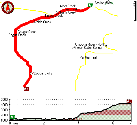
Trailhead 1 to Trailhead 2:
Total hiking length = 7 miles
Total climbing distance = 4 miles
Difficulty : Difficult
Casual Hiking Pace: 7 hours
Fast Hiking Pace: 4 hours

Trailhead 2 to Trailhead 1:
Total hiking length = 7 miles
Total climbing distance = 1.8 miles
Difficulty : Difficult
Casual Hiking Pace: 5.5 hours
Fast Hiking Pace: 3 hours
    Trailhead 1 back to Trailhead 1:
Total hiking length = 14 miles
Total climbing distance = 5.8 miles
Difficulty : Difficult
Casual Hiking Pace: 2 days
Fast Hiking Pace: 8 hours

Trailhead 2 back to Trailhead 2:
Total hiking length = 14 miles
Total climbing distance = 5.8 miles
Difficulty : Difficult
Casual Hiking Pace: 2 days
Fast Hiking Pace: 8 hours

Total elevation difference: 3396 feet


Best Western Oakridge Inn, Oakridge
29 miles away
This Oakridge, Oregon hotel offers a complimentary continental breakfast each morning and convenient access to a variety of outdoor activities. Discover the Best Western Oakridge Inn, nestled agains...
  
Moonstone Village Green Resort, Cottage Grove
31 miles away
Village Green Resort is located off Interstate 5, in Cottage Grove. The resort is six miles from the covered bridges, and approximately 30 miles from Eugene Airport. We are less than a mile from two g...
User input for Mott Trail, Central Cascade Range, Douglas County, Oregon:

Submit Input:
Your Name:
Write or Paste Input here:

Upload picture:      Review Guidelines


Outdoors Recreation Near Eugene-Springfield, Oregon
Very comprehensive list of a variety of outdoors recreation in the vicinity of Eugene-Springfield, Oregon, the metro area neareast to Mott Trail. Find info on campgrounds, hiking trails, ski resorts, lakes, beaches, parks, whitewater and more.

Current weather conditions at Mott Trail, Central Cascade Range, Douglas County, Oregon
WXPort

Local climate location: IDLEYLD PARK 13 miles away

Comfort Inn Cottage Grove, Cottage Grove
31 miles away

Holiday Inn Express COTTAGE GROVE, Cottage Grove
32 miles away
Welcome to the Holiday Inn Express in Cottage Grove.We are conveniently located in the Willamette Valley 30 miles south of Eugene just off I-5 at exit 174.We offer a free Continental Breakfast, an ind...

More Hotels and Campgrounds Near Mott Trail, Central Cascade Range, Douglas County, Oregon

OTHER_INFO
  Central Cascade Range Campgrounds
Complete list of all the campgrounds in the Central Cascade Range.

Central Cascade Range Outdoors Info
Complete outdoors info for the Central Cascade Range.

Oregon Hiking Trails
Complete list of all hiking trails in Oregon

Books about hiking trails in Oregon
List of books available on Amazon.com about hiking trails in Oregon.

Oregon Outdoors Index
This is a very comprehensive index of outdoors activities in the great state of Oregon.


TOPO
High quality water resistant topo map of Mott Trail, Central Cascade Range, Douglas County, Oregon.

OUTDOORS_GUIDE
These outdoors activities are available near Mott Trail.
 Trails Near Mott Trail:
Panther Trail, Douglas County County , 2 miles away, 9.3 hiking miles, 3150 feet elevation difference
Williams Creek Trail, Douglas County County , 3 miles away, 5.2 hiking miles, 2407 feet elevation difference
Red Butte Trail, Douglas County County , 8 miles away, 8.6 hiking miles, 1909 feet elevation difference
Leach Camp Trail, Douglas County County , 9 miles away, 1.1 hiking miles, 1608 feet elevation difference
Francis Way, Lane County County , 10 miles away,  .6 hiking miles, 136 feet elevation difference
Pass Creek Trail, Douglas County County , 10 miles away, 3.9 hiking miles, 1839 feet elevation difference
China Creek Trail, Lane County County , 11 miles away, 1.5 hiking miles, 992 feet elevation difference
 Camp Grounds Near Mott Trail:
River View RV Park, Idleyld Park, 11 miles away
Smith Springs Campground, Douglas County, 11 miles away
Buckhead Mountain Campground, Douglas County, 12 miles away
Big Twin Lakes Campground, Douglas County, 12 miles away
Weeping Rock Campground, Douglas County, 14 miles away
 Whitewater Near Mott Trail:
Umpqua River - North, Douglas County County , 1 miles away, Class III - 25.5 miles long (Soda Springs to Deadline Falls)
Canyon Creek, Douglas County County , 5 miles away, Class III-IV - 9 miles long (Confluence with Pass Creek to Steamboat Creek)
Little River, Douglas County County , 5 miles away, Class -blank- - 8 miles long (FS Road 165 to White Creek Campground)
Steamboat Creek, Douglas County County , 6 miles away, Class IV - 6 miles long (Steamboat Falls to Canton Creek Campground)
Steamboat Creek, Douglas County County , 8 miles away, Class II+(IV) - 9.5 miles long (City Creek to Steamboat Falls)
 National Parks Near Mott Trail:
Crater Lake National Park, Crater Lake - OR , 48 miles away
 Hotels Near Mott Trail:
Best Western Oakridge Inn, Oakridge , 29 miles away
Moonstone Village Green Resort, Cottage Grove , 31 miles away
Comfort Inn Cottage Grove, Cottage Grove , 31 miles away
Holiday Inn Express COTTAGE GROVE, Cottage Grove , 32 miles away
Comfort Inn & Suites Creswell, Creswell , 35 miles away

Outdoors related information copyright © Stratus-Pikpuk, Inc. - Detailed hotel information copyright © Interactive Hotel Solutions