| |
This trail has gone away. NFS has taken it off its maps and roads to access it are closed. Says Cliff Geddis
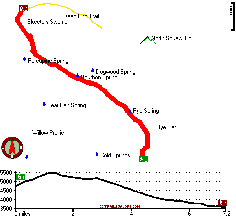
Mosquito Fish Lake Trail has a total elevation difference of 1,976 feet which is about average. This is a backpacking and hiking trail that is quite long, so don't forget to pack enough supplies. Of course, this is an overnight walk, 2 days normally, so make sure you've got all your overnight gear packed. Different parts of Mosquito Fish Lake Trail are at very different elevations, and that means that some parts of the great outdoors trail could be very different from other parts of it. At parts of the year this vicinity sees very little rain, so do check for current fire restrictions before you go if you plan to bring a stove or make a camp fire. Being 14.4 miles long; it's a long great outdoors trail. Mosquito Fish Lake Trail is a two ended great outdoors trail with two trailheads which means you have the option of trekking it one way if you have someone to pick you up at the other end.
|
Trailhead 1 to Trailhead 2:
Total hiking length = 7.2 miles
Total climbing distance = 1.5 miles
Difficulty : Difficult
Casual Hiking Pace:
5.5 hours
Fast Hiking Pace:
3 hours
Trailhead 2 to Trailhead 1:
Total hiking length = 7.2 miles
Total climbing distance = 4.6 miles
Difficulty : Difficult
Casual Hiking Pace:
7.5 hours
Fast Hiking Pace:
4 hours
| | Trailhead 1 back to Trailhead 1:
Total hiking length = 14.4 miles
Total climbing distance = 6.1 miles
Difficulty : Difficult
Casual Hiking Pace:
2 days
Fast Hiking Pace:
8.5 hours
Trailhead 2 back to Trailhead 2:
Total hiking length = 14.4 miles
Total climbing distance = 6.1 miles
Difficulty : Difficult
Casual Hiking Pace:
2 days
Fast Hiking Pace:
8.5 hours
|
Total elevation difference: 1976 feet
|


