| |
|
| | There are plenty of backpacking trails in Oregon; each one of them is different from the others. Hiking in Oregon is a perfect way to spend some time. Moore Creek Trail is a long drive away from Bend, but it is a fun place to trek. Now, this is roughly a 3-day hike, so it's a tremendous thing if your backpack is big enough to do the job. There are backpacking trails all over Oregon; one of those is Moore Creek Trail in Deschutes County. This wilderness trail is many miles long having an average number of uphill miles which makes this a very tough hiking |
|
and backpacking trail for advanced trekkers looking for a glorious challenge. With its 20.2 miles of walking distance; it's a long hiking trail. Hiking in Oregon is such a perfect thing to do. Summertime highs at Moore Creek Trail frequently tend to be in the 80's while nighttime
| | lows are frequently in the 40's. The cold days of the wintertime come with highs in the 40's with winter lows in the 20's overnight here at Moore Creek Trail. Great outdoors trails like this one here in the Central Cascade Range are a really good way to spend quality time in nature. The total elevation difference for Moore Creek Trail is 1,397 feet, and that is about average. Can’t wait to get out in nature, Moore Creek Trail in Deschutes County, Oregon is a really pleasant place to spend some time. This is a long hiking trail, so make sure you bring plenty | |
|
of supplies. This is an area covered with lots of hiking and backpacking trails. Moore Creek Trail frequently gets much precipitation; the wettest month of the year is typically December, that's the one that rains the most, and July meanwhile is the driest month. Moore Creek Trail
stays roughly within the same elevation zone the whole time which means the conditions are about the same from start to finish. At parts of the year this vicinity sees very little rain, so make sure you check current conditions and fire restrictions with local forest authorities
before you head out. Don’t forget to check for any current restrictions or closures before you go. There are two trailheads to chose from, one in each end, so if you can get a ride from someone, you can backcountry hike it just one way.
Briefly about the general area:
This river is so perfect. It's a magnificent idea to visit Antler Creek, it's near Moore Creek Trail, and camping is available at Shelter Cove Resort. You just can't imagine the amount of outdoors exciting things the Central Cascade Range has to offer. Since you're here at Moore
Creek Trail why not have a look at Maiden Peak Saddle, and don’t forget to have a look at Long Meadow since you're here at Moore Creek Trail. Why not stop at close by Douglas Creek while you're here at Moore Creek Trail; Cold Spring is a gorgeous spot to visit while you're
at Moore Creek Trail. If you want a delightful time in the great outdoors, just come on down to Moore Creek Trail. Why not camp at North Wickiup Campground if you're here at Moore Creek Trail, and McCord Cabin Spring is always fun to check out. Don't forget to explore Chinquapin
Point if you're here at Moore Creek Trail, and you have to certainly dedicate some time to Clover Meadow while you're here at Moore Creek Trail. Having a good time in the Central Cascade Range is trouble-free.
|
|
Location of Trailhead 1: Latitude 43.6362, Longitude -121.8584 - - Directions and Road Map
Location of Trailhead 2: Latitude 43.6734, Longitude -122.0195 - - Directions and Road Map

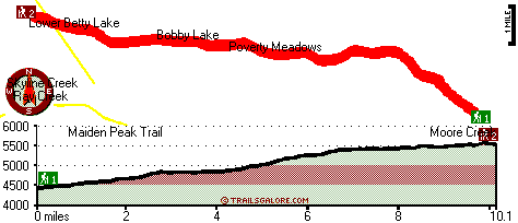
Trailhead 1 to Trailhead 2: Total hiking length = 10.1 miles Total climbing distance = 6.9 miles Difficulty : Difficult Casual Hiking Pace:
2 days
Fast Hiking Pace:
6 hours
Trailhead 2 to Trailhead 1: Total hiking length = 10.1 miles Total climbing distance = 1.3 miles Difficulty : Difficult Casual Hiking Pace:
7 hours
Fast Hiking Pace:
3.5 hours
| | Trailhead 1 back to Trailhead 1: Total hiking length = 20.2 miles Total climbing distance = 8.2 miles Difficulty : Difficult Casual Hiking Pace:
3 days
Fast Hiking Pace:
2 days
Trailhead 2 back to Trailhead 2: Total hiking length = 20.2 miles Total climbing distance = 8.2 miles Difficulty : Difficult Casual Hiking Pace:
3 days
Fast Hiking Pace:
2 days
|
Total elevation difference: 1397 feet

Best Western Newberry Station, La Pine
|
30 miles away
Stay at this La Pine, Oregon hotel, a central location to 5 of the major recreational areas in Oregon including Crater Lake and the 14 lake Cascade Lakes. Welcome to the Best Western Newberry Statio...
|
| |
Sunriver Resort, Sunriver
|
36 miles away
Sunriver Resort is located at the foot of the Cascade Mountain range in Central Oregon- 15 miles south of Bend. A four-star- full-service resort for family- couples and business. Offering world-class ...
|
|
User input for Moore Creek Trail, Central Cascade Range, Deschutes County, Oregon:

Outdoors Recreation Near Bend, Oregon Very comprehensive list of a variety of outdoors recreation in the vicinity of Bend, Oregon, the metro area neareast to Moore Creek Trail. Find info on campgrounds, hiking trails, ski resorts, lakes, beaches, parks, whitewater and more.
More Hotels and Campgrounds Near Moore Creek Trail, Central Cascade Range, Deschutes County, Oregon
| |
| |
 |
|
| These outdoors activities are available near Moore Creek Trail. |
| | Trails Near Moore Creek Trail:
 |
Twin Peaks Trail, Lane County
County
, 4 miles away, 7.9 hiking miles, 1368 feet elevation difference |
 |
Maiden Peak Trail, Lane County
County
, 5 miles away, 10.4 hiking miles, 3274 feet elevation difference |
 |
Crater Butte Trail, Klamath County
County
, 7 miles away, 8.4 hiking miles, 881 feet elevation difference |
 |
Fawn Lake Trail, Klamath County
County
, 8 miles away, 5.6 hiking miles, 863 feet elevation difference |
 |
Crain Prairie Trail, Lane County
County
, 8 miles away, 18.3 hiking miles, 504 feet elevation difference |
 |
Pretty Lake Trail, Klamath County
County
, 8 miles away, 6.8 hiking miles, 1098 feet elevation difference |
 |
Mount Ray Trail, Lane County
County
, 8 miles away, 4.6 hiking miles, 1058 feet elevation difference |
|
| | Whitewater Near Moore Creek Trail:
 |
Deschutes River, Deschutes County
County
, 20 miles away, Class I-IV - 9 miles long (Wickiup Dam to Pringle Falls) |
 |
McKenzie River - South Fork, Lane County
County
, 25 miles away, Class III-IV - 6.2 miles long (Dutch Oven Camp to Cougar Reservoir) |
 |
Horse Creek, Lane County
County
, 27 miles away, Class III - 11 miles long (above Separation Creek to McKenzie River) |
 |
Deschutes River, Deschutes County
County
, 27 miles away, Class I-II - 16 miles long (Pringle Falls to Big River Campground) |
 |
Hills Creek, Lane County
County
, 28 miles away, Class IV - 6 miles long (6 mi above Reservoir) |
|
| | Hotels Near Moore Creek Trail:
 |
Woodsman Country Lodge, Crescent
, 19 miles away |
 |
Crescent Motel, Crescent
, 19 miles away |
 |
Crater Lake Motel, Chemult
, 24 miles away |
 |
Chemult Motel, Chemult
, 25 miles away |
 |
Holiday Village Motel Trailer, Chemult
, 25 miles away |
|
|
|
 |
|