| |
|
| | Molalla Trail is a trail quite far from Portland-Vancouver-Beaverton, but you always have a nice time when you're backcountry hiking along it. There are numerous backcountry hiking trails in Oregon, and each one has its own unique prettiness. Here in the delightful state of Oregon backcountry hiking never gets boring. The hiking trail stays roughly within the same elevation zone the whole time which means the conditions are about the same from start to finish. Oregon is a good spot for backcountry trekkers. Molalla Trail is 6 miles long it's a mid length |
|
backcountry walk. Hitting the trails is always an exciting thing to do, and Molalla Trail in Clackamas County, Oregon is just the place. This backcountry trek shouldn't take more than 5.5 hours, but you never know stuff could go wrong and you could get stuck so be prepared for
| | that. There are backcountry hiking trails all over Oregon, and one of these is Molalla Trail in Clackamas County. Molalla Trail has a total elevation difference of 1,285 feet, and that is about average. High temperatures at Molalla Trail during the months of summer are in the 70's; through summer nights temperatures are in the 50's. Throughout the wintertime the highs are generally in the 40's; winter nights come with lows in the 30's to Molalla Trail. Molalla Trail is not that long but you should still bring some emergency supplies just in case something | |
|
happens. This is one of many backcountry hiking trails in the surrounding neighborhood. This wilderness trail is a normal length wilderness trail with an average amount of climbing distance which makes this backcountry hiking trail great for hard core backpackers looking for adventure.
Trails like this one here in the Central Cascade Range are a good way to explore these peaks. And keep in mind that there could be temporary safety restrictions in site. Molalla Trail sees pretty high levels of precipitation; during the month of December you get the most rain around
here while July is usually the driest month. There are two trailheads to chose from, one in each end, so backpacking it one way is an option if you can arrange for a ride back.
Briefly about the general area: Shower Creek is a great place to visit, and Molalla Trail
is a great location to visit for more than one day, B and B Rentals is a great location to camp nearby. Glide down the rapids of Clackamas River in a kayak, and Bagby Hot Springs is an inspiring location to visit while here. Places like Lost Creek Meadow are delightful to check
out, and Skookum Lake Campground is a great local campground. Be careful coming to the Central Cascade Range, you might not ever want to go back home again. Get soaked paddling on Collawash River; don't leave Molalla Trail without first paying a visit to Pegleg Falls. Now, you may feel that's a lot but there's even more exciting stuff to do here at Molalla Trail. Peggy Creek is a magnificent local stream.
|
|
Location of Trailhead 1: Latitude 44.9352, Longitude -122.204 - - Directions and Road Map
Location of Trailhead 2: Latitude 44.9286, Longitude -122.1533 - - Directions and Road Map

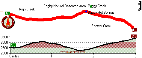
Trailhead 1 to Trailhead 2: Total hiking length = 3 miles Total climbing distance = 1.9 miles Difficulty : Medium Casual Hiking Pace:
3 hours
Fast Hiking Pace:
1.5 hours
Trailhead 2 to Trailhead 1: Total hiking length = 3 miles Total climbing distance = .9 miles Difficulty : Easy Casual Hiking Pace:
2.5 hours
Fast Hiking Pace:
1.5 hours
| | Trailhead 1 back to Trailhead 1: Total hiking length = 6 miles Total climbing distance = 2.8 miles Difficulty : Difficult Casual Hiking Pace:
5.5 hours
Fast Hiking Pace:
3.5 hours
Trailhead 2 back to Trailhead 2: Total hiking length = 6 miles Total climbing distance = 2.8 miles Difficulty : Difficult Casual Hiking Pace:
5.5 hours
Fast Hiking Pace:
3.5 hours
|
Total elevation difference: 1285 feet

Best Western Sandy Inn, Sandy
|
24 miles away
This Sandy, Oregon hotel is an interior corridor hotel offering guests easy access to Mt. Hood, the Rose Garden Convention Center and the Oregon Zoo at Washington Park. Enjoy beautiful mountain view...
|
| |
Resort at the Mountain, Welches
|
25 miles away
The Resort at The Mountain is the premier Northwest golf and ski resort located in the Highlands of Oregon just an hour east of Portland at the western base of Mt. Hood. The Resort features 160 gues...
|
|
User input for Molalla Trail, Central Cascade Range, Clackamas County, Oregon:

Outdoors Recreation Near Portland-Vancouver-Beaverton, Oregon-Washington Very comprehensive list of a variety of outdoors recreation in the vicinity of Portland-Vancouver-Beaverton, Oregon-Washington, the metro area neareast to Molalla Trail. Find info on campgrounds, hiking trails, ski resorts, lakes, beaches, parks, whitewater and more.
More Hotels and Campgrounds Near Molalla Trail, Central Cascade Range, Clackamas County, Oregon
| |
| |
 |
|
| These outdoors activities are available near Molalla Trail. |
| | Trails Near Molalla Trail:
 |
Whetstone Trail, Clackamas County
County
, 1 miles away, 3.2 hiking miles, 1456 feet elevation difference |
 |
South Fork Mountain Trail, Clackamas County
County
, 2 miles away, 5.6 hiking miles, 2378 feet elevation difference |
 |
Nohorn Trail, Clackamas County
County
, 3 miles away, 1.9 hiking miles, 472 feet elevation difference |
 |
East Mountain Trail, Clackamas County
County
, 3 miles away, 2.8 hiking miles, 479 feet elevation difference |
 |
Thunder Mountain Trail, Clackamas County
County
, 4 miles away, 4.6 hiking miles, 3377 feet elevation difference |
 |
Baty Silver King Trail, Clackamas County
County
, 5 miles away, 1 hiking miles, 335 feet elevation difference |
 |
Twin Lakes Trail, Marion County
County
, 6 miles away, 8.4 hiking miles, 888 feet elevation difference |
|
| | Whitewater Near Molalla Trail:
 |
Collawash River, Marion County
County
, 9 miles away, Class IV - 5.5 miles long (Mile 5.5 bridge to Two Rivers Picnic Area) |
 |
Clackamas River, Clackamas County
County
, 11 miles away, Class -blank- - 9.2 miles long (Collawash River to Three Lynx Power Station) |
 |
Collawash River, Marion County
County
, 11 miles away, Class III-IV(V) - 5 miles long (Elk Lake Creek to river mile 5.5) |
 |
Breitenbush River, Marion County
County
, 11 miles away, Class IV - 8.2 miles long (Cleator Bend Campground to Detroit Lake) |
 |
Elkhorn Creek, -blank- County
County
, 12 miles away, Class III-V - 10 miles long (to confluence with Little North Santiam) |
|
| | Hotels Near Molalla Trail:
 |
Best Western Sandy Inn, Sandy
, 24 miles away |
 |
Resort at the Mountain, Welches
, 25 miles away |
 |
Whispering Woods (Vri), Welches
, 25 miles away |
 |
Howard Johnson Gresham, Gresham
, 32 miles away |
 |
Best Western Pony Soldier-Gresham, Gresham
, 33 miles away |
|
|
|
 |
|