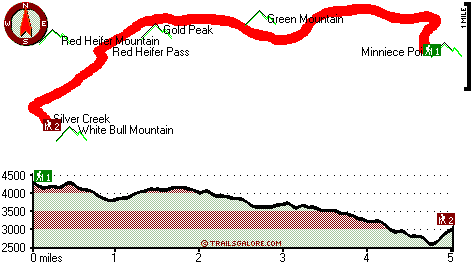
| |
|
| | Here in Oregon backcountry backpacking is a brilliant way to spend some time. When was the last time you got out in the great outdoors a bit? if you happen to be in Linn County of Oregon, Minniece Point Trail is a magnificent local hiking trail for doing a bit of leg stretching. It's a long trip from Albany-Lebanon to Minniece Point Trail, but there's nice natural attractiveness awaiting you here along it. Wilderness trails like this one here in the Central Cascade Range are a really tremendous way to spend quality time in the outdoors. This is a wilderness |
|
trail that is quite long, so make sure you bring plenty of supplies. Outdoors folks generally like this part of Oregon. Minniece Point Trail is a very long wilderness trail with an average amount of climbing distance which makes it a nice trail for experienced hikers in glorious
| | shape. A great deal of rainfall falls at Minniece Point Trail; December is the wettest month with most rain, and the driest month is July. Every single Oregon great outdoors trail has something unique to offer. Don’t forget to check for any current restrictions or closures before you go. Some parts of Minniece Point Trail are much higher up than other parts of the trail, so keep in mind that you may need to dress differently at different elevations. There are so many trails in this vicinity. There are many fine great outdoors trails in Oregon, and one of | |
|
these is Minniece Point Trail in Linn County. Minniece Point Trail has a total elevation difference of 2,044 feet which is about average. With its 10 miles of walking distance; it's considered a longer hike. The time needed for this backcountry trek is roughly 9 hours, but you
never know stuff could go wrong and you could get stuck so be prepared for that. This hiking and backpacking trail has two trailheads, so if you can get a ride from someone, you can hike it just one way. All through the warmest time of the year at Minniece Point Trail temperatures
are generally in the 70's. Throughout the moonlight hours it's mostly in the 40's. Throughout the winter highs are mostly in the 40's while the cold winter nights at Minniece Point Trail are in the 30's.
Briefly about the general area: Having a magnificent time in the
Central Cascade Range is trouble-free. Minniece Point Trail is near Red Heifer Pass which is definitely worth taking a look at; get your pulse rate up on the great whitewater of Santiam River - Middle. You'll need more than a day to look at everything Minniece Point Trail has to
offer, you can camp at Detroit Lake State Park; there's some flowing water close by, Gregg Creek is a stream you can stop by while here. McQuade Creek is in the neighborhood of Minniece Point Trail and is always a pleasure to visit; you can run the rapids of Canal Creek. If
you want a glorious time in the great outdoors, just come on down to Minniece Point Trail. There's so much to do here at Minniece Point Trail that you need to camp here for a while, B and B Rentals is a pleasant site for that. A fine site like Little Meadows here at Minniece Point Trail is too great to miss, and a trip to McNabb Falls will fill your soul with glorious feelings.
|
|
Location of Trailhead 1: Latitude 44.602, Longitude -122.2374 - - Directions and Road Map
Location of Trailhead 2: Latitude 44.5898, Longitude -122.2994 - - Directions and Road Map

Trailhead 1 to Trailhead 2: Total hiking length = 5 miles Total climbing distance = 1.7 miles Difficulty : Medium Casual Hiking Pace:
4 hours
Fast Hiking Pace:
2.5 hours
Trailhead 2 to Trailhead 1: Total hiking length = 5 miles Total climbing distance = 2.6 miles Difficulty : Medium Casual Hiking Pace:
4.5 hours
Fast Hiking Pace:
2.5 hours
| | Trailhead 1 back to Trailhead 1: Total hiking length = 10 miles Total climbing distance = 4.3 miles Difficulty : Difficult Casual Hiking Pace:
9 hours
Fast Hiking Pace:
6 hours
Trailhead 2 back to Trailhead 2: Total hiking length = 10 miles Total climbing distance = 4.3 miles Difficulty : Difficult Casual Hiking Pace:
9 hours
Fast Hiking Pace:
6 hours
|
Total elevation difference: 2044 feet

Rodeway Inn & Suites, Sublimity
|
38 miles away
The Rodeway Inn hotel is located 15 miles east of Salem, Oregon. Enjoy the quiet country setting. Relax in our indoor pool and hot tub or workout in our exercise room. We offer cable with HBO and ESPN...
|
| |
Best Western Sandy Inn, Sandy
|
39 miles away
This Sandy, Oregon hotel is an interior corridor hotel offering guests easy access to Mt. Hood, the Rose Garden Convention Center and the Oregon Zoo at Washington Park. Enjoy beautiful mountain view...
|
|
User input for Minniece Point Trail, Central Cascade Range, Linn County, Oregon:

Outdoors Recreation Near Albany-Lebanon, Oregon Very comprehensive list of a variety of outdoors recreation in the vicinity of Albany-Lebanon, Oregon, the metro area neareast to Minniece Point Trail. Find info on campgrounds, hiking trails, ski resorts, lakes, beaches, parks, whitewater and more.
More Hotels and Campgrounds Near Minniece Point Trail, Central Cascade Range, Linn County, Oregon
| |
| |
 |
|
| These outdoors activities are available near Minniece Point Trail. |
| | Trails Near Minniece Point Trail:
 |
Chimney Peak Trail, Linn County
County
, 2 miles away, 19 hiking miles, 2987 feet elevation difference |
 |
Volcano Trail, Linn County
County
, 4 miles away, 1.4 hiking miles, 1090 feet elevation difference |
 |
Cool Camp Trail, Linn County
County
, 7 miles away, 2.9 hiking miles, 1258 feet elevation difference |
 |
Swamp Peak Trail, Linn County
County
, 8 miles away, 4.4 hiking miles, 981 feet elevation difference |
 |
Rocky Top Trail, Marion County
County
, 9 miles away, 2.7 hiking miles, 526 feet elevation difference |
 |
Gordan Peak Trail, Linn County
County
, 10 miles away, 4.6 hiking miles, 441 feet elevation difference |
 |
French Creek Trail, Marion County
County
, 11 miles away, 8.9 hiking miles, 4067 feet elevation difference |
|
| | Whitewater Near Minniece Point Trail:
 |
Santiam River - Middle, Linn County
County
, 5 miles away, Class III-IV - 15.5 miles long (Pyramid Creek to Green Peter Reservoir) |
 |
Canal Creek, Linn County
County
, 5 miles away, Class IV-V - 1.2 miles long (1.2 mi above Quartzville Creek) |
 |
Quartzville Creek, Linn County
County
, 7 miles away, Class IV-V - 14 miles long (Above Gregg Creek to Green Peter Reservoir) |
 |
Santiam River - North, Marion/ Linn County
County
, 9 miles away, Class III-V - 4.7 miles long (Big Cliff Dam to Packsaddle Park) |
 |
Elkhorn Creek, -blank- County
County
, 12 miles away, Class III-V - 10 miles long (to confluence with Little North Santiam) |
|
| | Hotels Near Minniece Point Trail:
 |
Rodeway Inn & Suites, Sublimity
, 38 miles away |
 |
Best Western Sandy Inn, Sandy
, 39 miles away |
 |
Oregon Garden Resort, Silverton
, 41 miles away |
 |
Resort at the Mountain, Welches
, 42 miles away |
 |
Whispering Woods (Vri), Welches
, 42 miles away |
|
|
|
 |
|