| |
|
| | Each one of the many backpacking and hiking trails of Oregon is worth trekking. Gotta get out of the town man, and Michigan Heights Trail in Lane County, Oregon is a tremendous choice. Michigan Heights Trail is a long drive away from Albany-Lebanon, but backcountry hiking it is splendid joy any time. Backcountry backpacking here in Oregon is the splendid thing to do. Please follow all local rules about fires and camping. This backpacking trail is not that long but you should still bring some emergency supplies just in case something happens. Different |
|
parts of Michigan Heights Trail are at very different elevations, and that means that some parts of the backpacking and hiking trail could be very different from other parts of it. Delightful backpacking and hiking trails in Oregon are in abundance, and Michigan Heights Trail is
| | one of them, and it's in Lane County. This is one of a very small number of hiking and backpacking trails in this vicinity. This hike shouldn't take more than 5.5 hours, but of course some people walk a bit slower and some a bit faster. This trail is a mid length trail having an average number of uphill miles which makes it a tremendous hiking and backpacking trail for experienced hikers in perfect shape. At Michigan Heights Trail through the summer months highs are in the 80's, and the night is quite cooler of course, ordinarily in the 50's. The winter | |
|
brings highs down to the 40's, and night lows during the winter for Michigan Heights Trail tend to be in the 30's. The high level of rainfall makes Michigan Heights Trail a reasonably wet place; during December this region sees the most rain; the driest of the months is July. At
parts of the year this neighborhood sees very little rain, so make sure you check current conditions and fire restrictions with local forest authorities before you head out. The total elevation difference for this backcountry hiking trail is 2,179 feet which is about average. This
part of Oregon has a great deal of available outdoors activities. Michigan Heights Trail is 6 miles long it's a mid length backcountry trek. Backcountry trails like this one here in the Central Cascade Range are a very magnificent way to see these highlands. Michigan Heights Trail
has two trailheads, so backcountry trekking it one way is an option if you can arrange for a ride back.
Briefly about the general area: Take a side visit to Minney Creek. You'll need more than a day to explore everything Michigan Heights Trail has to offer, you can camp
at Foster Lake Campground. Michigan Heights Trail is a brilliant spot to visit for more than one day, Menears Bend Campground is a brilliant spot to camp nearby; in case you don’t mind getting drenched, you can always go whitewater paddling on Calapooia River. So much exciting
stuff in the Central Cascade Range, just extraordinary. Whitewater paddling is good on Wiley Creek, and swing by North Fork North Fork Gate Creek it's a fine place to check out.
|
|
Location of Trailhead 1: Latitude 44.1724, Longitude -122.5243 - - Directions and Road Map
Location of Trailhead 2: Latitude 44.2133, Longitude -122.5276 - - Directions and Road Map

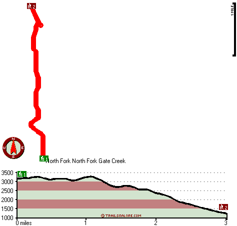
Trailhead 1 to Trailhead 2: Total hiking length = 3 miles Total climbing distance = .6 miles Difficulty : Easy Casual Hiking Pace:
2 hours
Fast Hiking Pace:
1 hours
Trailhead 2 to Trailhead 1: Total hiking length = 3 miles Total climbing distance = 2 miles Difficulty : Difficult Casual Hiking Pace:
3 hours
Fast Hiking Pace:
2 hours
| | Trailhead 1 back to Trailhead 1: Total hiking length = 6 miles Total climbing distance = 2.6 miles Difficulty : Difficult Casual Hiking Pace:
5.5 hours
Fast Hiking Pace:
3.5 hours
Trailhead 2 back to Trailhead 2: Total hiking length = 6 miles Total climbing distance = 2.6 miles Difficulty : Difficult Casual Hiking Pace:
5.5 hours
Fast Hiking Pace:
3.5 hours
|
Total elevation difference: 2179 feet

Best Western Oakridge Inn, Oakridge
|
22 miles away
This Oakridge, Oregon hotel offers a complimentary continental breakfast each morning and convenient access to a variety of outdoor activities. Discover the Best Western Oakridge Inn, nestled agains...
|
| |
Village Inn, Springfield
|
33 miles away
The Village Inn Springfield Oregon is your ideal choice for Springfield Oregon hotels. The Village Inn provides lodging near the University of Oregon, Autzen Stadium, Downtown Eugene and just blocks a...
|
|
User input for Michigan Heights Trail, Central Cascade Range, Lane County, Oregon:

Outdoors Recreation Near Albany-Lebanon, Oregon Very comprehensive list of a variety of outdoors recreation in the vicinity of Albany-Lebanon, Oregon, the metro area neareast to Michigan Heights Trail. Find info on campgrounds, hiking trails, ski resorts, lakes, beaches, parks, whitewater and more.
|
Current weather conditions at Michigan Heights Trail, Central Cascade Range, Lane County, Oregon

Local climate location: LEABURG 10 miles away

           
| |
Holiday Inn EUGENE NORTH-SPRINGFIELD, Springfield
|
36 miles away
Eugene Hotel Offers Free Shuttle Service For a convenient location and 'excellent'- rated service, visit the newly built, 100% smoke free Holiday Inn Eugene North - Springfield, Oregon. Our hotel's...
|
Courtyard Eugene Springfield, Springfield
|
36 miles away
Located off of I-5 with easy access to area destinations such as the University of Oregon, Autzen Stadium and Lane County fairgrounds, the Courtyard Eugene Springfield makes leisure or business travel...
|
|
More Hotels and Campgrounds Near Michigan Heights Trail, Central Cascade Range, Lane County, Oregon
| |
| |
 |
|
| These outdoors activities are available near Michigan Heights Trail. |
| | Whitewater Near Michigan Heights Trail:
 |
Calapooia River, Linn County
County
, 3 miles away, Class IV - 9 miles long (22 miles above Holley to 13 Mile Bridge) |
 |
Wiley Creek, Linn County
County
, 8 miles away, Class IV-V - 6 miles long (Above Wiley Creek Gorge to Little Wiley Creek Confluence) |
 |
Calapooia River, Linn County
County
, 11 miles away, Class III - 9.5 miles long (13 miles above Holley to Concrete Bridge) |
 |
Santiam River - South, Linn County
County
, 12 miles away, Class III-V+ - 16.5 miles long (Mountain House to Foster Reservoir) |
 |
Canyon Creek, -blank- County
County
, 12 miles away, Class V - 7 miles long (7 Mile Bridge to South Santiam River) |
|
| | Hotels Near Michigan Heights Trail:
 |
Best Western Oakridge Inn, Oakridge
, 22 miles away |
 |
Village Inn, Springfield
, 33 miles away |
 |
Holiday Inn EUGENE NORTH-SPRINGFIELD, Springfield
, 36 miles away |
 |
Courtyard Eugene Springfield, Springfield
, 36 miles away |
 |
Comfort Inn & Suites Creswell, Creswell
, 36 miles away |
|
|
|
 |
|