Oregon hiking trails - McKinley Creek Trail, Central Cascade Range, Lane County

   
  McKinley Creek Trail is not very close to Eugene-Springfield at all, but it is a nice great outdoors hiking trail. Backcountry backpacking in Oregon is something that is always fun to do. There are great outdoors hiking trails all over Oregon, and one of those is McKinley Creek Trail in Lane County. In Oregon you never run out of outdoors fun. You can't spend all your time indoors you need to get out once in a while, and if you happen to be in Lane County of Oregon, McKinley Creek Trail is a nice local great outdoors hiking trail for doing a bit of leg
    stretching. McKinley Creek Trail is a mid-length hiking trail with an average amount of climbing distance which makes it a tremendous great outdoors hiking trail for experienced backcountry trekkers in good shape. McKinley Creek Trail is 8.6 miles long it's an average length backcountry
hiking trail. Please follow all local rules about fires and camping. 
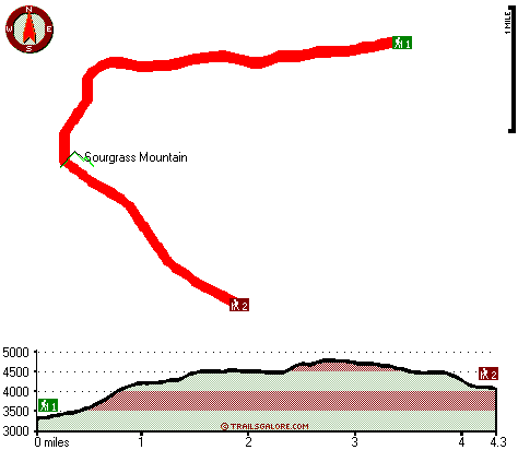
McKinley Creek Trail has a total elevation difference of 1,580 feet which is about average. McKinley Creek Trail gets lots of water; most of the rain falls through November; the driest month is July. Summertime highs at McKinley Creek Trail regularly tend to be in the 80's while night lows are generally in the 50's. For the duration of the wintertime highs are generally in the 40's with winter lows in the 30's overnight here at McKinley Creek Trail. Each great outdoors hiking trail in  
Oregon has its own unique beauty. Now this backpacking and hiking trail is pretty long, so don't forget to pack enough supplies. Sometimes this backpacking and hiking trail gets really dry, so do check for current fire restrictions before you go if you plan to bring a stove or make a camp fire. The time needed for this trek is roughly 7.5 hours, but you never know stuff could go wrong and you could get stuck so be prepared for that. There are two trailheads to chose from, one in each end which means you have the option of backcountry trekking it one way if you have someone to pick you up at the other end. There are so many great outdoors hiking trails in this region. Different parts of this backcountry hiking trail are at very different elevations which of course means you need to be prepared for different conditions on different parts of the backcountry hiking trail. The hiking trails of the Central Cascade Range are the best way to enjoy these mountaintops.

Briefly about the general area:
Man, is there a lot of entertaining things to do in the Central Cascade Range. Nevergo Creek flows through this area. You'll need more than a day to look at everything McKinley Creek Trail has to offer, you can camp at Oakridge Mobile Home Park. You can run the rapids of Willamette River - Middle Fork in close proximity to McKinley Creek Trail, and there's some flowing water close by, Dartmouth Creek is a stream you can check out while here.
There's so much to do here at McKinley Creek Trail that you need to camp here for a while, Oakridge RV Park is a glorious place for that. Windy Pass is in the vicinity of McKinley Creek Trail and is a brilliant site, and get your heart beating on the good whitewater of Willamette River - North Fork of Middle Fork.

Location of Trailhead 1: Latitude 43.8794, Longitude -122.4515
- - Directions and Road Map

Location of Trailhead 2: Latitude 43.8495, Longitude -122.4702
- - Directions and Road Map


Trailhead 1 to Trailhead 2:
Total hiking length = 4.3 miles
Total climbing distance = 2 miles
Difficulty : Medium
Casual Hiking Pace: 4 hours
Fast Hiking Pace: 2 hours

Trailhead 2 to Trailhead 1:
Total hiking length = 4.3 miles
Total climbing distance = 1.4 miles
Difficulty : Easy
Casual Hiking Pace: 3.5 hours
Fast Hiking Pace: 2 hours
    Trailhead 1 back to Trailhead 1:
Total hiking length = 8.6 miles
Total climbing distance = 3.4 miles
Difficulty : Difficult
Casual Hiking Pace: 7.5 hours
Fast Hiking Pace: 5 hours

Trailhead 2 back to Trailhead 2:
Total hiking length = 8.6 miles
Total climbing distance = 3.4 miles
Difficulty : Difficult
Casual Hiking Pace: 7.5 hours
Fast Hiking Pace: 5 hours

Total elevation difference: 1580 feet


Best Western Oakridge Inn, Oakridge
6 miles away
This Oakridge, Oregon hotel offers a complimentary continental breakfast each morning and convenient access to a variety of outdoor activities. Discover the Best Western Oakridge Inn, nestled agains...
  
Comfort Inn & Suites Creswell, Creswell
37 miles away
Welcome to the Comfort Inn and Suites of Creswell. This hotel is close to a golf course and is within walking distance of shops and restaurants. We are just a short drive to rivers, lakes and other ou...
User input for McKinley Creek Trail, Central Cascade Range, Lane County, Oregon:

Submit Input:
Your Name:
Write or Paste Input here:

Upload picture:      Review Guidelines


Outdoors Recreation Near Eugene-Springfield, Oregon
Very comprehensive list of a variety of outdoors recreation in the vicinity of Eugene-Springfield, Oregon, the metro area neareast to McKinley Creek Trail. Find info on campgrounds, hiking trails, ski resorts, lakes, beaches, parks, whitewater and more.

Current weather conditions at McKinley Creek Trail, Central Cascade Range, Lane County, Oregon
WXPort

Local climate location: LEABURG 10 miles away

Village Inn, Springfield
38 miles away
The Village Inn Springfield Oregon is your ideal choice for Springfield Oregon hotels. The Village Inn provides lodging near the University of Oregon, Autzen Stadium, Downtown Eugene and just blocks a...

Super 8 Creswell/South Eugene, Creswell
38 miles away
Conveniently located on I-5 at Exit, 182, our Super 8 is AAA approved. We have a friendly staff and are also Pet Friendly. We offer a SuperStart Breakfast, Free High Speed Wirelless Internet, an Out...

More Hotels and Campgrounds Near McKinley Creek Trail, Central Cascade Range, Lane County, Oregon

OTHER_INFO
  Central Cascade Range Campgrounds
Complete list of all the campgrounds in the Central Cascade Range.

Central Cascade Range Outdoors Info
Complete outdoors info for the Central Cascade Range.

Oregon Hiking Trails
Complete list of all hiking trails in Oregon

Books about hiking trails in Oregon
List of books available on Amazon.com about hiking trails in Oregon.

Oregon Outdoors Index
This is a very comprehensive index of outdoors activities in the great state of Oregon.


TOPO
High quality water resistant topo map of McKinley Creek Trail, Central Cascade Range, Lane County, Oregon.

OUTDOORS_GUIDE
These outdoors activities are available near McKinley Creek Trail.
 Trails Near McKinley Creek Trail:
Cain Cabin Trail, Lane County County , 3 miles away, 3.6 hiking miles, 2516 feet elevation difference
Tire Mountain Trail, Lane County County , 3 miles away, 2.4 hiking miles, 722 feet elevation difference
Alpine Trail, Lane County County , 3 miles away, 5.1 hiking miles, 2291 feet elevation difference
Gold Point Trail, Lane County County , 5 miles away,  5.8 hiking miles, 2706 feet elevation difference
Cabin Creek Trail, Lane County County , 6 miles away, 2.1 hiking miles, 1792 feet elevation difference
Sourgrass Trail, Lane County County , 6 miles away, 1.8 hiking miles, 911 feet elevation difference
Cloverpatch Trail, Lane County County , 6 miles away, 3.3 hiking miles, 1327 feet elevation difference
 Camp Grounds Near McKinley Creek Trail:
Oakridge Mobile Home Park, Oakridge, 6 miles away
Oakridge RV Park, Oakridge, 6 miles away
Errin Campground, Lane County, 6 miles away
Casey's Riverside Park, Westfir, 7 miles away
Upper End Campground, Lane County, 15 miles away
 Whitewater Near McKinley Creek Trail:
Willamette River - North Fork of Middle Fork, Lane County County , 4 miles away, Class IV-V - 13.5 miles long (to Westfir)
Willamette River - Middle Fork, Lane County County , 6 miles away, Class II - 12.5 miles long (Hills Creek Dam to Lookout Point Reservoir)
Salmon Creek, Lane County County , 7 miles away, Class II-V - 12 miles long (Top of Upper Salmon Creek Gorge to Oakridge)
Christy Creek, Lane County County , 9 miles away, Class III-V(V+) - 9 miles long (to Confluence with Willamette)
Salt Creek, Lane County County , 11 miles away, Class III-IV - 7.2 miles long (McCredie Hot Springs to Rigdon Road Bridge)
 National Parks Near McKinley Creek Trail:
Crater Lake National Park, Crater Lake - OR , 53 miles away
 Hotels Near McKinley Creek Trail:
Best Western Oakridge Inn, Oakridge , 6 miles away
Comfort Inn & Suites Creswell, Creswell , 37 miles away
Village Inn, Springfield , 38 miles away
Super 8 Creswell/South Eugene, Creswell , 38 miles away
Moonstone Village Green Resort, Cottage Grove , 40 miles away

Outdoors related information copyright © Stratus-Pikpuk, Inc. - Detailed hotel information copyright © Interactive Hotel Solutions