| |
|
| | You'll need to go far from Eugene-Springfield to get to Mayflower Trail, but hiking it is good pleasure any time. Backcountry hiking in Oregon is something that is always fun to do. Every single Oregon hiking trail has its own unique attractiveness. The time needed for this backcountry hike is roughly 4 hours, but you never know stuff could go wrong and you could get stuck so be prepared for that. Even though this is not a very long hiking trail you should still bring some emergency supplies just in case something happens. Mayflower Trail goes through some very |
|
different elevations, so keep in mind that you may need to dress differently at different elevations. Mayflower Trail sees pretty high levels of rain; November is when you get the most rain here, and the driest month of the year is July. There are many delightful hiking trails
| | in Oregon; Mayflower Trail in Lane County is one of them. A visit to Oregon is not complete without some backcountry trekking. This hiking trail has a total elevation difference of 1,953 feet, and that is about average. Sometimes this hiking trail gets really dry, so do check for current fire restrictions before you go if you plan to bring a stove or make a camp fire. Mayflower Trail is a mid-length trail having an average number of uphill miles which makes it a nice great outdoors hiking trail for the average person looking for a nice adventure. The warmest | |
|
time of the year at Mayflower Trail arrives with high temperatures in the 70's. All through the moonlight hours it's usually in the 40's. Daytime highs during the winter are in the 40's with winter lows in the 30's overnight here at Mayflower Trail. With its 4.4 miles of walking
distance it's a mid length trek. Please follow all local rules about fires and camping. Hey, time for a backcountry walk don’t you think? Mayflower Trail in Lane County, Oregon is a wonderful spot for getting out. These trails here in the Central Cascade Range are a splendid way
to explore these mountains. Mayflower Trail is a one trailhead hiking trail, so you'll be hiking it in and back out. This is one of a very small number of great outdoors hiking trails in this region.
Briefly about the general area: Camping is available at Slim Chance
Campground, and get yourself into a kayak and hit Champion Creek. So many fun things to do in the Central Cascade Range, not enough time. Why not camp at Casey's Riverside Park while you're here at Mayflower Trail; get drenched paddling on Brice Creek. Knott Spring is an inspiring
location to check out during your stay, and getting to Knott Creek from Mayflower Trail is painless. Looking for some flowing water? Try Hobart Creek; a pleasant visit to Crystal Basin is a good way to spend an afternoon. This place, Mayflower Trail, it just has so much outdoors
amusing stuff. If you crave a little side journey, try Helena Saddle, and a short visit to Grouse Mountain Falls is always worthwhile. There's no way anyone can get bored here in the Central Cascade Range.
|
|
Location of Trailhead: Latitude 43.5858, Longitude -122.617 - - Directions and Road Map
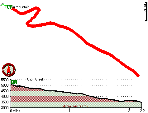
Total in and out hiking length = 4.4 miles
Total climbing distance = 1.8 miles
Difficulty : Medium
Casual Hiking Pace:
4 hours
Fast Hiking Pace:
2.5 hours
Total elevation difference: 1953 feet

Best Western Oakridge Inn, Oakridge
|
12 miles away
This Oakridge, Oregon hotel offers a complimentary continental breakfast each morning and convenient access to a variety of outdoor activities. Discover the Best Western Oakridge Inn, nestled agains...
|
| |
Moonstone Village Green Resort, Cottage Grove
|
32 miles away
Village Green Resort is located off Interstate 5, in Cottage Grove. The resort is six miles from the covered bridges, and approximately 30 miles from Eugene Airport. We are less than a mile from two g...
|
|
User input for Mayflower Trail, Central Cascade Range, Lane County, Oregon:

Outdoors Recreation Near Eugene-Springfield, Oregon Very comprehensive list of a variety of outdoors recreation in the vicinity of Eugene-Springfield, Oregon, the metro area neareast to Mayflower Trail. Find info on campgrounds, hiking trails, ski resorts, lakes, beaches, parks, whitewater and more.
More Hotels and Campgrounds Near Mayflower Trail, Central Cascade Range, Lane County, Oregon
| |
| |
 |
|
| These outdoors activities are available near Mayflower Trail. |
| | Trails Near Mayflower Trail:
 |
Steamboat Trail, Lane County
County
, 1 miles away, 5.9 hiking miles, 2985 feet elevation difference |
 |
Skeeter Camp Trail, Lane County
County
, 4 miles away, 2.4 hiking miles, 1108 feet elevation difference |
|
| | Whitewater Near Mayflower Trail:
 |
Brice Creek, Lane County
County
, 3 miles away, Class IV-V - 4.5 miles long (Parker Falls to Champion Creek) |
 |
Champion Creek, Lane County
County
, 4 miles away, Class IV-V - 1.1 miles long (Gorge 1 mile above Brice Creek to Brice Creek) |
 |
Brice Creek, Lane County
County
, 6 miles away, Class IV-V - 5 miles long (Champion Creek to Cedar Creek Campground) |
 |
Steamboat Creek, Douglas County
County
, 11 miles away, Class II+(IV) - 9.5 miles long (City Creek to Steamboat Falls) |
 |
Willamette River - Middle Fork, Lane County
County
, 12 miles away, Class II - 12.5 miles long (Hills Creek Dam to Lookout Point Reservoir) |
|
| | Hotels Near Mayflower Trail:
 |
Best Western Oakridge Inn, Oakridge
, 12 miles away |
 |
Moonstone Village Green Resort, Cottage Grove
, 32 miles away |
 |
Comfort Inn Cottage Grove, Cottage Grove
, 32 miles away |
 |
Holiday Inn Express Cottage Grove, Or, Cottage Grove
, 32 miles away |
 |
Super 8 Creswell, Creswell
, 33 miles away |
|
|
|
 |
|