| |
|
| | Alright, enough of spending all this time inside a building, time to get out, and Lowe Creek Trail in Clackamas County, Oregon is just the place. There are many great hiking and backpacking trails in Oregon; among these are Lowe Creek Trail in Clackamas County. If you happen to be in Oregon, why not go backcountry backpacking, it is something that is always fun to do. Don’t forget to check for any current restrictions or closures before you go. Lowe Creek Trail stays roughly within the same elevation zone the whole time which means the conditions are |
|
about the same from start to finish. The wilderness hiking trails of the Central Cascade Range are a good way to explore these highlands. This is just one of a large number of backcountry hiking trails in this area. Every hiking and backpacking trail in Oregon is different from
| | the others. This great outdoors trail sometimes gets very dry, so don’t forget to check for any current fire restrictions before you go. Being 9.2 miles long; it's longer than many hiking trails. This trek shouldn't take more than 8 hours, but of course some folks walk a bit slower and some a bit faster. High temperatures at Lowe Creek Trail during the days of summer are in the 70's. When the night sets in temperatures plunge down into the 50's. The winter brings highs down to the 40's with temperatures at Lowe Creek Trail dipping down into the 30's through | |
|
winter nights. Backcountry backpacking here in Oregon is a must. Keep in mind that this is a long great outdoors trail, so make sure you bring plenty of supplies. A lot of rainfall falls at Lowe Creek Trail; the month with most of the rain is December; the driest of the months
is July. Lowe Creek Trail is a backcountry trail rather far from Hood River, but it sure is a a magnificent backcountry trail. This backpacking trail has a total elevation difference of 1,307 feet which is an average number. Lowe Creek Trail is a two ended backpacking trail with
two trailheads which means you have the option of backpacking it one way if you have someone to pick you up at the other end. Lowe Creek Trail is a very long wilderness hiking trail having an average number of uphill miles which makes this backcountry hiking trail magnificent for
hard core backpackers looking for adventure.
Briefly about the general area: What a spot this is for outdoors people. Don't leave Lowe Creek Trail without first paying a visit to Fadeaway Spring, and do set aside some time for Jim Meadow since you're here at Lowe Creek
Trail. Whohoo, so much enjoyable stuff in one place! The Central Cascade Range rocks! It's always wonderful to explore Tarzan Springs. Now, you may think that's heaps but there's even more fun stuff to do here in the Central Cascade Range. Tumble Creek is a stream that you
may bump into while here, and Lowe Creek Trail is delightful enough to spend more than a day at, Frazier Fork Campground is a delightful local campground. There's so much to do here at Lowe Creek Trail that you need to camp here for a while, Frazier Turnaround Campground is a wonderful
location for that, and Graham Pass is another tremendous site to stop at close by. Get yourself into a kayak and hit Clackamas River, and there's some flowing water nearby, Fawn Creek is a stream you can take a look at during your stay. If you come at the right time of year,
Collawash River offers some splendid whitewater, and since you're here at Lowe Creek Trail it's a nice idea to visit Rhododendron Meadow.
|
|
Location of Trailhead 1: Latitude 44.9256, Longitude -121.9428 - - Directions and Road Map
Location of Trailhead 2: Latitude 44.9641, Longitude -121.9565 - - Directions and Road Map

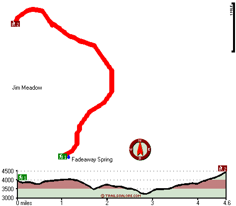
Trailhead 1 to Trailhead 2: Total hiking length = 4.6 miles Total climbing distance = 2.5 miles Difficulty : Medium Casual Hiking Pace:
4.5 hours
Fast Hiking Pace:
2.5 hours
Trailhead 2 to Trailhead 1: Total hiking length = 4.6 miles Total climbing distance = 1.5 miles Difficulty : Easy Casual Hiking Pace:
4 hours
Fast Hiking Pace:
2 hours
| | Trailhead 1 back to Trailhead 1: Total hiking length = 9.2 miles Total climbing distance = 4 miles Difficulty : Difficult Casual Hiking Pace:
8 hours
Fast Hiking Pace:
5.5 hours
Trailhead 2 back to Trailhead 2: Total hiking length = 9.2 miles Total climbing distance = 4 miles Difficulty : Difficult Casual Hiking Pace:
8 hours
Fast Hiking Pace:
5.5 hours
|
Total elevation difference: 1307 feet

Whispering Woods (Vri), Welches
|
19 miles away
Whispering Woods is a resort destination east of Portland which opened in 1981 with 42 condominiums. The second phase of 24 additional condominiums opened in 1992. The resort offers a clubhouse with a...
|
| |
Resort at the Mountain, Welches
|
19 miles away
The Resort at The Mountain is the premier Northwest golf and ski resort located in the Highlands of Oregon just an hour east of Portland at the western base of Mt. Hood. The Resort features 160 gues...
|
|
User input for Lowe Creek Trail, Central Cascade Range, Clackamas County, Oregon:

Outdoors Recreation Near Hood River, Oregon Very comprehensive list of a variety of outdoors recreation in the vicinity of Hood River, Oregon, the metro area neareast to Lowe Creek Trail. Find info on campgrounds, hiking trails, ski resorts, lakes, beaches, parks, whitewater and more.
More Hotels and Campgrounds Near Lowe Creek Trail, Central Cascade Range, Clackamas County, Oregon
| |
| |
 |
|
| These outdoors activities are available near Lowe Creek Trail. |
| | Trails Near Lowe Creek Trail:
 |
Rhododendron Ridge Trail, Clackamas County
County
, 2 miles away, 4 hiking miles, 887 feet elevation difference |
 |
Round Lake Trail, Marion County
County
, 4 miles away, 3.5 hiking miles, 1470 feet elevation difference |
 |
Hunter Camp Way, Marion County
County
, 4 miles away, 1.7 hiking miles, 638 feet elevation difference |
 |
Twin Meadows Trail, Marion County
County
, 5 miles away, 2.3 hiking miles, 1063 feet elevation difference |
 |
East Fork Way, Marion County
County
, 6 miles away, 2.1 hiking miles, 913 feet elevation difference |
 |
Janus Butte Trail, Marion County
County
, 6 miles away, 8.2 hiking miles, 2376 feet elevation difference |
 |
Scorpion Mountain Trail, Marion County
County
, 7 miles away, 0.5 hiking miles, 176 feet elevation difference |
|
| | Whitewater Near Lowe Creek Trail:
 |
Clackamas River, Clackamas County
County
, 5 miles away, Class III-IV - 8 miles long (June Creek Br. to Collawash River) |
 |
Collawash River, Marion County
County
, 6 miles away, Class III-IV(V) - 5 miles long (Elk Lake Creek to river mile 5.5) |
 |
Clackamas River - Oak Grove Fork, Clackamas County
County
, 8 miles away, Class III-V(V+) - 5 miles long (Lower Five Miles to Clackamas River) |
 |
Collawash River, Marion County
County
, 8 miles away, Class IV - 5.5 miles long (Mile 5.5 bridge to Two Rivers Picnic Area) |
 |
Clackamas River, Clackamas County
County
, 11 miles away, Class -blank- - 9.2 miles long (Collawash River to Three Lynx Power Station) |
|
| | Hotels Near Lowe Creek Trail:
 |
Whispering Woods (Vri), Welches
, 19 miles away |
 |
Resort at the Mountain, Welches
, 19 miles away |
 |
Mount Hood Inn, Government Camp
, 21 miles away |
 |
Best Western Sandy Inn, Sandy
, 32 miles away |
 |
Lodge at Suttle Lake, Sisters
, 34 miles away |
|
|
|
 |
|